
Kennedy's Creek Land System
Download the pdf version of this document: Kennedy's Creek Land System (PDF - 534 KB)
To view the information, PDF requires the use of a PDF reader. This can be installed for free from the Adobe website (external link).
| From Princetown, stretching northwards, an undulating plain can be found extending up into the catchment of Kennedys Creek. The southern parts consist of a series of north-nor’-west and south-sou’-east-oriented ridges, but the major part of the land system is a plain with dendritic drainage pattern. The higher parts of the landscape have deeply weathered soils with yellow and red mottled. Most slopes, however, carry heavier-textured soils with dark-coloured and coarsely structured subsoils. They extend up to the crests and ridges in many areas; less weathered profiles occupy the lower parts of the landscape. This pattern resembles that found in many other land systems on Tertiary sediments. The distinguishing features here are the dominance of the coarsely structured soils in the landscape, and the absence of lateritic cappings. Dairy farming is the main land use, and only small areas still remain under native forest. The coarsely structured subsoils are dispersible and gully and tunnel erosion have occurred. On recently cleared areas, particular care is needed to prevent gullies being initiated. Landslips also occur on these soils. | 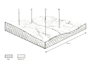 |
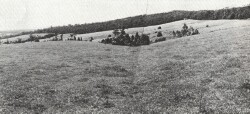 Only a few forested areas remain, dairy farming being the main land use | 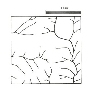 |
Area: 95 km2 | Component and its proportion of land system | |||
1 20% | 2 65% | 3 6% | 4 9% | |
| CLIMATE Rainfall, mm | Annual: 95 – 1,050, lowest January (40), highest August (130) | |||
| Temperature, 0oC | Annual: 13, lowest July (8.5), highest February (18) | |||
Temperature: less than 10oC (av.) June – August | ||||
Precipitation: less than potential evapotranspiration November – March | ||||
| GEOLOGY Age, lithology | Miocene unconsolidated marine clay, silt and sand | Recent alluvium | ||
| TOPOGRAPHY Landscape | Undulating plain | |||
| Elevation, m | 15 – 150 | |||
| Local relief, m | 70 | |||
| Drainage pattern | Predominantly dendritic with some trellis | |||
| Drainage density, km/km2 | 4.0 | |||
| Land form | Gentle rise | Alluvial terrace | ||
| Land form element | Upper slope, crest | Middle slope | Lower slope | - |
| Slope (and range), % | 9 (4-15) | 10 (4-20) | 10 (7-35) | 5 (1-9) |
| Slope shape | Convex | Straight | Concave | (Variable – mostly straight) |
| NATIVE VEGETATION Structure | Open forest | Open forest | Open forest | Woodland |
| Dominant species | E. obliqua, E. viminalis, occasionally E. ovata | E. aromaphloia, E. viminalis, E. obliqua, E. radiata, E. ovata | E. obliqua, E. radiata, occasionally E. viminalis | E. ovata, E. obliqua, E. viminalis |
| SOIL Parent material | Clay and silt | Clay and silt | Clay and silt | Alluvial clay, silt and sand |
| Description | Mottled yellow and red gradational soils | Yellow-brown gradational soils, coarse structure | Grey-brown gradational soils | Mottled yellow and grey gradational soils |
| Surface texture | Fine sandy loam | Fine sandy loam | Fine sandy loam | Sandy loam |
| Permeability | Moderate | Low | Moderate | Low |
| Depth, m | >2 | >2 | >2 | >2 |
| LAND USE | Cleared areas: Dairy farming; beef cattle and sheep grazing; water supply Uncleared areas: Water supply; hardwood forestry; nature conservation | |||
| SOIL DETERIORATION HAZARD Critical land features, processes, forms | Low inherent fertility, phosphorus fixation and steep slopes lead to sheet erosion and nutrient decline. | High dispersible clay subsoils are prone to gully and tunnel erosion. Periodic saturation leads to landslips. Steeper slopes are prone to sheet erosion of nutrient-rich surface horizons. | Steeper slopes are prone to sheet erosion. Dispersible clay subsoils on moderate steep slopes are prone to gully erosion. | Dispersible clay subsoils of low permeability are prone to gully erosion. High water tables lead to seasonal waterlogging and soil compaction. |
© State of Victoria (Agriculture Victoria) 1996 - 2025.

This work, Victorian Resources Online, is licensed under a Creative Commons Attribution 4.0 licence. You are free to re-use the work under that licence, on the condition that you credit the State of Victoria (Agriculture Victoria) as author, indicate if changes were made and comply with the other licence terms.
The licence does not apply to ‘branding’ or some ‘images or photographs’ that may be owned by third parties. We ask you to seek prior approval to use images using the VRO feedback form. Access to higher quality images can also be provided on request.
This page was last updated on 23/03/2020.