Mount Mackenzie Land System
Download the pdf version of this document: Mount Mackenzie Land System (PDF - 485KB)
To view the information, PDF requires the use of a PDF reader. This can be installed for free from the Adobe website (external link).
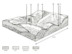
| Steeply dissected hills abut either side of the middle and lower reaches of the Gellibrand River. Dissection into Tertiary clay, silt and sand has resulted in steep slopes and narrow drainage lines. The finely textured Tertiary sediments outcropping in these areas has resulted in heavier-textured soils than those found in the neighbouring Chapple Vale land system. Moisture stress and fertility are not as limiting to plant growth, so open forests of Eucalyptus obliqua and E. baxteri have developed on most sites. Included in the land system are dissected river terraces along the valley of the Gellibrand River and these possess well-developed soils with coarse-structured subsoils. The higher parts of the landscape may also possess such soils where Kennedys Creek land system is adjacent, or sand soils where the Chapple Vale land system is nearby. Most areas remain forested but areas abutting the flood plains have been cleared to provide winter pastures for dairy cattle. Pines have been established on previously forested land. Sheet erosion and landslips have occurred on many of the steeper slopes where the native vegetation has been removed and the rugged nature of the terrain make most land uses difficult. |  |
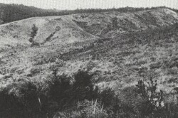
 The steep dissected hills of the Mount Mackenzie land system originally supported open forest communities, but many areas have been extensively cleared for pine conversion and grazing. |  |
Area: 59 km2 | Component and its proportion of land system | ||||||
1 40% | 2 8% | 3 9% | 4 25% | 5 8% | 6 7% | 7 3% | |
| CLIMATE Rainfall, mm | Annual: 950 – 1,100, lowest January (45), highest August (120) | ||||||
| Temperature, 0oC | Annual: 13, lowest July (8), highest February (18) | ||||||
Temperature: less than 10oC (av.) June – August | |||||||
Precipitation: less than potential evapotranspiration mid November – March | |||||||
| GEOLOGY Age, lithology | Paleocene unconsolidated marine sand, clay and silt | ||||||
| TOPOGRAPHY Landscape | Deeply dissected hills in the middle and lower reaches of the Gellibrand River catchment | ||||||
| Elevation, m | 15 –180 | ||||||
| Local relief, m | 100 | ||||||
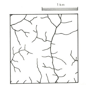
| Drainage pattern | Dendritic with some radial | ||||||
| Drainage density, km/km2 | 3.3 | ||||||
| Land form | Hill | Valley floor | Terrace | ||||
| Land form element | Slope, crest | Crest, spur, mainly in south | Crest, slope | Slope, crest | Broad slight depression | - | - |
| Slope (and range), % | 33 (4-63) | 14 (4-19) | 32 (22-45) | 37 (31-49) | 14 (2-21) | 4 (0-7) | 5 (1-9) |
| Slope shape | Convex | Convex | Convex | Convex | Concave | Concave | Convex |
| NATIVE VEGETATION Structure | Open forest | Open forest | Low woodland | Open forest | Low woodland | Woodland | Open forest |
| Dominant species | E. baxteri, E. nitida, E. obliqua, E. radiata | E. obliqua, E. baxteri, E. viminalis, E. ovata | E. baxteri, E. nitida | E. baxteri, E. obliqua | E. nitida, E. baxteri | E. obliqua, E. baxteri | E. obliqua, E. ovata, E. baxteri |
| SOIL Parent material | Clay, silt and sand | Clay, silt and sand | Sand | Clay, silt and sand | Sand, colluvial sand | Plant remains, alluvial sand and clay | Alluvial clay, silt and sand |
| Description | Yellow gradational sols, weak structure | Yellow-brown gradational soils, coarse structure | Grey sand soils, uniform texture | Red gradational soils, weak structure | Grey sand soils, with hardpans, uniform texture | Black sand soils, uniform texture | Yellow-brown gradational soils, coarse structure |
| Surface texture | Sandy loam | Fine sandy loam | Loamy sand | Sandy loam | Loamy sand | Loamy sand | Fine sandy loam |
| Permeability | High | Low | Very high | High | Very low | High | Low |
| Depth, m | >2 | >2 | >2 | >2 | 0.6 | >2 | >2 |
| LAND USE | Uncleared areas: Hardwood forestry for sawlogs, posts and poles; water supply; nature conservation; quarrying of ironstone; softwood forestry Minor cleared areas: Dairy farming; beef cattle grazing. | ||||||
| SOIL DETERIORATION HAZARD Critical land features, processes, forms | Weakly structured soils on steep slopes are prone to sheet, rill, scour gully erosion and landslips. Low inherent fertility and high permeability lead to nutrient decline. | Dispersible clay subsoils of low permeability are prone to gully erosion. | Very low inherent fertility and high permeability lead to nutrient decline. Steeper slopes with compacted soils are prone to sheet, rill and scour gully erosion. | Weakly structured soils on steep slopes are prone to sheet and rill erosion and landslips. Low inherent fertility and high permeability lead to nutrient decline. | Hardpans restrict vertical drainage leading to seasonal waterlogging. Very low inherent fertility with leaching of permeable highly acidic surface soils lead to nutrient decline. | High water tables lead to waterlogging and soil compaction. Rapid run-off from adjacent hills lead to flooding and siltation. | Dispersible clay subsoils of low permeability are prone to gully erosion. Low permeabilities and high water tables lead to waterlogging and soil compaction. |


