Barongarook Land System
Download the pdf version of this document: Barongarook Land System (PDF - 493 KB)
To view the information, PDF requires the use of a PDF reader. This can be installed for free from the Adobe website (external link).
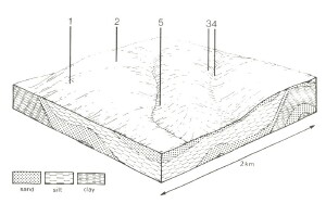
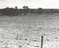
| North of Forrest and extending towards Colac, undulating plains with often deeply weathered soils are found. The geology is mainly Tertiary clay with minor outcrops of sand. Redistribution of surface sand has resulted in polygenetic soils over much of the landscape, with weak hardpan development and impeded drainage. Surface soils seem to be naturally low in plant nutrients. Many areas remain uncleared and support open forests dominated by Eucalyptus obliqua and E. radiata. E. baxteri is notably absent in this slightly drier region. Other areas have been cleared for agriculture or converted to pines. The main hazards to land use are loss of soil structure, by compaction, and leaching of nutrients. |  |
|
|
Area: 92 km2 | Component and its proportion of land system | ||||
1 8% | 2 55% | 3 15% | 4 15% | 5 7% | |
| CLIMATE Rainfall, mm | Annual: 100 – 900, lowest January (40), highest August (80) | ||||
| Temperature, 0oC | Annual: 13, lowest July (8), highest February (18) | ||||
Temperature: less than 10oC (av.) June – August | |||||
Precipitation: less than potential evapotranspiration late October – early April | |||||
| GEOLOGY Age, lithology | Pliocene unconsolidated clay, silt and sand | ||||
Recent sand veneer | |||||
| TOPOGRAPHY Landscape | Gently undulating to rolling plain in the western parts of the Barwon catchment | ||||
| Elevation, m | 120 –280 | ||||
| Local relief, m | 30 | ||||
| Drainage pattern | Dendritic | ||||
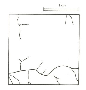
| Drainage density, km/km2 | 1.2 | ||||
| Land form | Undulating plan | ||||
| Land form element | Steep slope | Crest, upper slope | Upper and middle slope | Lower slope | Drainage line |
| Slope (and range), % | 25 (15-40) | 5 (0-10) | 5 (0-10) | 7 (1-15) | 1 (10-2) |
| Slope shape | Linear | Convex | Convex | Linear | Concave |
| NATIVE VEGETATION Structure | Open forest | Open forest | Open forest | Woodland | Woodland |
| Dominant species | E. obliqua, E. radiata, E. viminalis | E. obliqua, E. radiata, occasionally E. ovata, E. viminalis | E. radiata, E. obliqua, E. nitida | E. radiata, E. nitida | E. ovata, E. radiata occasionally E. aromaphloia |
| SOIL Parent material | Clay, silt and sand | Clay, silt and sand | Clay, silt and sand with quartz sand veneer | Clay, silt and sand with quartz sand veneer | Alluvium |
| Description | Yellow gradational soils, weak structure | Mottled yellow and red gradational soils | Grey sand soils, structured clay underlay | Grey sand soils, weakly structured clay underlay | Mottled yellow and grey gradational soils |
| Surface texture | Sandy loam | Loam | Sandy loam | Sandy loam | Loam |
| Permeability | High | Moderate | Low | Low | Moderate |
| Depth, m | >2 | >2 | >2 | >2 | >2 |
| LAND USE | Cleared areas: Sheep and beef cattle grazing; dairy farming. Uncleared areas: Hardwood forestry for sawlogs, post and poles; nature conservation; active and passive recreation; softwood forestry; forest grazing. | ||||
| SOIL DETERIORATION HAZARD Critical land features, processes, forms | Steeper slopes with weak-structured surfaces are prone to sheet erosion. | Low inherent fertility and phosphorus fixation lead to nutrient decline. | Low inherent fertility with leaching of permeable surface horizons lead to nutrient decline. | Low permeability and seasonal perched water table lead to waterlogging and soil compaction. | High seasonal water table leads to waterlogging and soil compaction. |


