Deepdene Land System
Download the pdf version of this document: Deepdene Land System (PDF - 589 KB)
To view the information, PDF requires the use of a PDF reader. This can be installed for free from the Adobe website (external link).
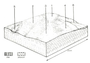
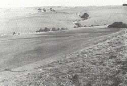
| An extensive lateritic plateau to the north of the Otway Range has been dissected by the Barwon River and its tributaries. There are several plateau remnants separated by alluvial plains of the Barwon River land system. In general, flat or gently undulating plains occupy the highest parts of the landscape, and these are surrounded by gentle slopes leading to slightly lower surfaces or by steep scarps falling away to the alluvial plains. The areas to the west of the Barwon River is more dissected, with generally steeper slopes. The soils on the highest levels have been strongly lateritized, with ironstone throughout the profile and concentrated in discontinuous layers at about 1.2 m depth. Similar soils without ironstone are found on lower levels, while the gentle slopes between these levels possess heavier-textured soils with coarse blocky structures in the subsoils. Clearing has been widespread and the land is used for sheep and beef cattle grazing as well as some dairying. Soil salting has occurred in some areas, and major problems have arisen due to gully and tunnel erosion. The more dissected areas to the west of the Barwon are the most susceptible, and damage has been widespread. |  |
 Dispersible subsoils on the steeper slopes of this landscape are highly susceptible to gully erosion and landslips. |  |
Area: 179 km2 | Component and its proportion of land system | |||||
1 40% | 2 15% | 3 20% | 4 10% | 5 7% | 6 8% | |
| CLIMATE Rainfall, mm | Annual: 650 – 700, lowest January (30), highest August (85) | |||||
Temperature, 0oC | Annual: 13, lowest July (8), highest February (9) | |||||
Temperature: less than 10oC (av.) June – August | ||||||
Precipitation: less than potential evapotranspiration early October – late April | ||||||
GEOLOGY Age, lithology | Pliocene clay, silt and sand | |||||
TOPOGRAPHY Landscape | Undulating plain inland of the Otway Range | |||||
Elevation, m | 120 - 190 | |||||
Local relief, m | 40 | |||||
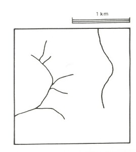
Drainage pattern | Dendritic | |||||
Drainage density, km/km2 | 1.0 | |||||
| Land form | Rise | High level terrace | Drainage line | Scarp | ||
| Land form element | Broad crest | Gentle upper slope | Gentle broad slope | - | - | - |
| Slope (and range), % | 1 (0-2) | 5 (2-1) | 3 (0-7) | 1 (0-2) | 0 (0-1) | 35 (10-50) |
| Slope shape | Linear | Linear | Convex | Linear | Concave | Linear, Convex |
| NATIVE VEGETATION Structure | Open forest | Open forest | Open forest | Woodland | Closed scrub | Open forest |
| Dominant species | E. viminalis, E. obliqua, E. radiata | E. viminalis, E. ovata | E. obliqua, E. viminalis, E. ovata, E. radiata | E. viminalis, E obliqua, E. ovata | Leptospermum juniperinum Melaleuca squarrosa | E. obliqua, E. viminalis |
| SOIL Parent material | Lateritized sediments | Clay | Clay, silt and sand | Alluvial clay, silt and sand | Alluvial clay, silt and sand | Clay, silt and sand |
| Description | Mottled yellow and red duplex soils with ironstone | Yellow-brown sodic duplex soils, coarse structure | Mottled yellow and red duplex soils | Yellow-brown calcareous sodic soils, coarse structure | Grey gradational soils | Yellow sodic duplex soils |
| Surface texture | Sandy loam | Fine sandy loam | Sandy loam | Fine sandy loam | Fine sandy clay loam | Sandy loam |
| Permeability | Moderate | Low | Moderate | Low | Very low | Moderate |
| Depth, m | 1.2 | >2 | >2 | >2 | >2 | >2 |
| LAND USE | Cleared areas: Sheep and beef cattle grazing; cash and row cropping; dairy farming. | |||||
| SOIL DETERIORATION HAZARD Critical land features, processes, forms | Low inherent fertility, phosphate fixation, and permeable surface soils lead to nutrient decline. | Dispersible clay subsoils of low permeability are prone to gully and tunnel erosion. Sodic subsoils of low permeability receiving saline seepage are prone to soil salting. | Low inherent fertility, phosphate fixation and permeable surface soils lead to nutrient decline. | Dispersible clay subsoils of low permeability are prone to gully and tunnel erosion and soil salting. | High seasonal water table leads to waterlogging, soil compaction and soil salting. Dispersible clay subsoils are prone to gully and tunnel erosion. | Dispersible soils on steep slopes subject to periodic saturation are prone to landslips and sheet erosion. |


