
Land Degradation at McHugh’s Gully
S.C. Boucher
School of Geography and Environmental Science
Monash University, Victoria 3800
 | McHugh's Gully June 2004 | 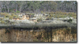 |
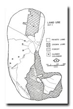
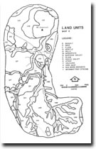
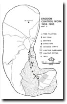
 Location Map | This article is a summary of the report written by Mr Chris Smyth for the former Soil Conservation Authority and published in 1982. Smyth's work contains an historical theme which traces the development of McHugh's Gully from the time of European settlement. The report was not widely distributed and the present document serves to distill the essential aspects of land degradation contained in the report. McHugh’s Gully is located approximately 40 km north of Ballarat alongside the Clunes –Talbot road and drains into McCallum’s Creek. The site forms part of the North Central catchment management region. The topography, land-use, land units and history of erosion control work (between 1959-65) in the area are evident from maps 2, 3, 4 and 5 respectively. |
| These maps were prepared by the author no information sources were specified. | |||
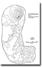 Topography | |||
The average annual rainfall totals for Clunes (310 m Above Sea Level) and Talbot (250 m ASL) are 583 mm and 546 mm respectively. The pattern of rainfall is slightly winter-dominant, with the approximately 30 % of the annual total falling between June-August. The seasons of spring and autumn yield approximately 25 % of annual rainfall each. The duration of the growing season is between 7-9 months and is limited by winter frosts as well as high evaporation and low soil moisture levels in late summer and early autumn.
From the time of European settlement, the local Eucalyptus spp. forests were subjected to clearing and burning. The land on which McHugh’s Gully is located (i.e. the Dunach Forest run leased by Alexander McCallum) was being grazed by sheep in 1841. In the 1850s the various species were also used to provide props (i.e. box and blue gum), laths (i.e. stringybark), squared logs, sawn timber and firewood (i.e. box, ironbark and red gum) for gold mining purposes. The extensive demand for timber caused severe damage to the forests and, furthermore, regrowth was cut as soon as it was considered useful.
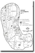 Crown Allotments | A closer look at land selection The release of land in the McHugh’s Gully area began as early as 1855. The better land was selected first. This was the land along the creeks and on the basalt plain. The creek flats were subdivided into small allotments ranging from 2 to 10 hectares. The less productive basalt plain was subdvided into allotments ranging between 20 and 60 hectares. The assumption behing this was that the larger allotments were required on the less productive land to match the total production of the better land. The shape of the allotments varied also. On the basalt plain the allotments were laid out on a square grid, such as the Parish of Beckworth. On the Ordovician land in the Parish of Eglinton the situation was quite different. “The country is exceedingly rough and hilly so that we cannot expect the blocks to fit in like a chess board” (Joseph Smith, surveyor, Lands File, Crown Allotment X1) |
The land between Mt. Grenock and McCallum’s Creek was selected beween 1856 and 1859. Peter MacVean purchased some of these allotments. He also purchased extensive areas of the basalt plain in the area during 1860. MacVean held the Dunach Forest Run pastoral lease from 1862 to 1869. Some of the creek flats land between McHugh’s Gully and Dunach was taken up in 1856 and 1857. Frederick Hull purchased some of this land. The Hull family still lives in the area. Until the Grant Land Act of 1865, any potentially gold-bearing land had been withheld from selection. In the McHugh’s Gully area this was the Ordovician hills. It would not have been particularly attractive to the early settlers anyway. The land was rough and stony, with forest that would have to be cleared. In the past settlers tended to avoid inferior forested land. High prices were paid for good quality land without forest, such as creek flats and grassy plains. This gave quick returns and the expensive business of clearing was unnecessary. Unfortunately, many settlers did not have the money to pick and choose. In the narrow alluvial valleys of the Ordovician hills some settlers saw potential for cultivation. In the 1860s and 1870s attempts were made to realize this potential in the catchment of McHugh’s Gully. The first selectors in the catchment of McHugh’s Gully were Giovanni Brusaschi (pronounced Brososky) and Patrick McHugh - the man whose name was given to the Gully. The catchment is situated in Section II of the Parish of Eglinton (see above map). In 1872 Brusaschi was given an “occupation licence” (a feature of the 1865 Grant Land Act) for Crown Allotment (CA) Y1. By 1875 he was cultivating almost 5 hectares of this 49 hectare block, growing wheat, oats, barley and peas. (Later he was to establish a vineyard). He had also built a dam and fenced off the land with a post and rail fence. During 1881 he purchased the block for 119 pounds. The hills surrounding McHugh’s Gully are today known as the Brusaschi Hills after this vigneron and farmer. Under the Grant Land Act of 1865 it became legal for labourers, miners and tradesmen to gain occupation licences for lots of 8 hectares or less, within 16 kilometres of the goldfields. Special mining conditions often attached to the use of this type of land. In 1867 Patrick McHugh, a labourer, married with two children, was issued with an occupation licence for CA X. McHugh set to work clearing some of the land, building a post and rail fence and a small cottage. By 1871 he was able to buy the land, paying 39 pounds for the 16 hectares. This was not the only block of land purchased by Patrick McHugh. He also bought CAs 42A3, 42A4, and X1. Prior to purchase he had also held these under occupation licences or leases. McHugh cultivated the narrow alluvial valleys on his land. On CA X he ploughed 25% of the block. Across the Clunes – Talbot road, on 42A3, he cultivated 40% of the 8 hectare block. The remainder of this land was rough and stony - of little use. This meant that he was unable to cultivate the amount required under the conditions of his occupation licence. When explaining this in 1874, on his application to lease CA X1, he said: “Because the land is schistose ranges and totally unfit for cultivation and if I ploughed up the little gully the first flood would carry away the soil and my house is just on the adjoining land where I reside” (Lands File, Crown Allotment X1). One can only wonder just how many settlers ignored McHugh’s line of reasoning and tried to satisfy the conditions of their licences. The number was probably very large. (Sections C7-8) | |
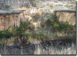
| McHugh's Gully Appears Patrick McHugh was obviously aware of the erosion hazard associated with the cultivation of his land. His comments are quite enlightened for a time when the Government was encouraging settlers to clear and plough their ground, with little concern for the consequences. Serious gully erosion finally occurred in the form that McHugh described – gully erosion. It is difficult to date this, but it may have begun in a small way during McHugh’s time, becoming much worse by the turn of the century. The first official concern seems to have been in the 1920s, when gully erosion began to threaten the Clunes-Talbot Road. In 1934 the Country Roads Board was forced to realign the road. It is, however, possible to suggest the probable causes of the erosion. One major cause was the extensive forest clearance that occurred to supply the timber requirements of the mines, towns and railways. The result was an increase in the amount of water flowing through the drainage system, including McHugh’s Gully. Secondly, road transport often led to erosion problems. Two roads passed through the McHugh’s Gully area. One of these was the Ballarat-Maryborough Road. It no longer exists but its route can be found to the west of the Gully – across the ridge. Coaches and carts travelling along the road caused deep ruts to form in the surface. After heavy rains these deepened still further. The result was an extensive gully system which still exists today. The other road was the Clunes-Talbot Road, which passed down through McHugh’s Gully. Wheel rut formation may have also been a problem along this road, although runoff from it into an adjacent drainage line could have been a more important factor in erosion. A drainage line was marked on an 1872 map of Crown Allotment 42A3... McHugh’s Gully passes through this allotment. The drainage line was significant enough for the surveyor to indicate the direction of flow. The drainage line ran parallel to the road reserve. At certain spots it ran within the road reserve. The drainage line closely follows the alignment of the gully erosion. Water would have run off the Clunes-Talbot Road and flowed along the drainage line. More water would have come from further up the catchment. Clearance of the catchment in those times would have increased the amount of water eventually flowing along the drainage line. The result of increased flow would have been the downcutting of the drainage line. Other drainage lines were also marked on the map. These flowed off the Ordovician ridge to the west. They closely align with the finger gullying so evident in the Crown Allotment today. Headward erosion along these lines would have created the finger gullies. A farm track was also marked on the 1872 map. It may have further increased the runoff flowing into the drainage line. Across to the east of the Clunes-Talbot Road some of the drainage lines were labelled as gullies on an 1872 survey map of CA X1. This labelling differs from other maps of the time which usually labelled the narrow valleys as gullies and not the drainage lines. Consideration must also be given to the cultivation of the catchment that began in the 1860s. The soil was ploughed to enable the planting of crops such as oats, wheat, peas, barley and vines. If ploughing was done down the slope then the soil would have been taken away during rain. More water would have quickly flowed across the surface rather than infiltrating the soil. Cultivation was restricted to the narrow valleys that exist between the Ordovician ridges. It is along these narrow valleys that gully erosion has occurred. The worst is on CA 42A3 and CA X, both cultivated by Patrick McHugh. The dispersible soils were unable to cope with their disturbance and the concentration of water into the drainage lines. This may have been further accentuated by the use of dam water for irrigation, if that was the reason for Giovanni Brusaschi building his dam. Finally, the lowering of the base levels of both gullies and McCallum’s Creek would have also had a major effect on erosion. McHugh’s Gully joined the gully along the Ballarat-Maryborough Road at the Antrim Arms Hotel… From there they flowed as one until reaching McCallum’s Creek. The two gullies would have contributed to the lowering of one another’s base level and thus encouraged further downcutting and headward erosion. This would have been increased if McCallum’s Creek was also lowering its base level at that time. (Sections C8-10) |
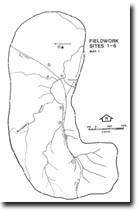 Fieldwork Sites |
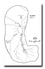 Slides Map | The next map serves as a location guide for the slides of particular degradation problems. For individual slide information see clickable list below. | ||||
| Slide 2A Slide 2B Slide 3A Slide 3B Slide 3C Slide 3D Slide 4A Slide 4B Slide 4C Slide 4D | Slide 5A Slide 5B Slide 5C Slide 5D Slide 6A Slide 6B Slide 6C Slide 6D Slide 7A Slide 7B | Slide 8A Slide 8B Slide 9A Slide 9B Slide 10 Slide 11 Slide 12A Slide 12B Slide 13A Slide 13B | Slide 14 Slide 15A Slide 15B Slide 15C Slide 15D Slide 16A Slide 16B Slide 16C Slide 16D Slide 17 | Slide 18 | |
Reclamation
The Soil Conservation Authority commenced works in the 1950s and ceased in 1965. Measures included contour furrowing which exacerbated the erosion of McHugh’s Gully by causing B horizon sapping whereby that horizon breaks down leaving the A horizon to collapse later. Tree planting and fencing-in also took place in conjunction with the construction of a diversion bank (which channelled water into the gully at a safe point). Silt traps, groynes and stone walls have been built at other sites. Some of the tree species used to stabilize the gully included silver poplars, weeping willows, basket willows and cork elms.
Reference
Smyth, C., 1982: McHugh's Gully: A Land Use and Management Teaching Resource Kit, Soil Conservation Authority of Victoria, Kew.
© State of Victoria (Agriculture Victoria) 1996 - 2025.

This work, Victorian Resources Online, is licensed under a Creative Commons Attribution 4.0 licence. You are free to re-use the work under that licence, on the condition that you credit the State of Victoria (Agriculture Victoria) as author, indicate if changes were made and comply with the other licence terms.
The licence does not apply to ‘branding’ or some ‘images or photographs’ that may be owned by third parties. We ask you to seek prior approval to use images using the VRO feedback form. Access to higher quality images can also be provided on request.
This page was last updated on 23/03/2020.