
Environmental Monitoring Sites
Environmental Monitoring Annual Report 2002/03
Environmental Quality Monitoring in North Central Victoria is being undertaken in order to:
- Establish baseline data to determine the current condition of significant wetlands and remnant vegetation sites across the North Central region (41 sites).
- Determine if salinity levels and mitigation works are improving, stabilising or degrading the current condition of the sites being monitored.
This map shows the locations of Environmental Monitoring Sites for remnant vegetation condition as well as wetland condition in the North Central region. The map also shows the Salinity Management Plan areas. | 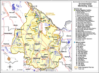 Environmental Monitoring Sites |
Background
As a response to increasing problems associated with salinity, the Victorian Government Salinity Program released ‘Salt Action:Joint Action’ in 1988. One of the first steps of the Program was to instigate the production of Salinity Management Plans (SMPs) for catchments across Victoria.
- The Victorian Statewide Salinity Monitoring Strategy was released in March 1996 to provide guidelines for tracking the effectiveness of the Victorian Salinity Program and SMPs. Monitoring of Environmental Quality was one component of this Strategy. It involves the assessment of the condition of significant wetlands and remnant vegetation in a Plan’s area to determine if salinity levels and salinity mitigation works are improving, stabilising or degrading the current condition of the environment being monitored.
- To meet the requirements of the Victorian Salinity Program, an Environmental Monitoring Program was developed and implemented for the Avoca, Avon-Richardson, Boort West of Loddon, Campaspe West, Kerang-Swan Hill, Torrumbarry East of Loddon and Tragowel Plains Salinity Management Plan (SMP) areas (which incorporate all of the North Central CMA region). More recently, two plans are being developed (i.e. Loddon Murray Land and Water Management Strategy and the draft Second Generation Dryland Salinity Management Plan) which will consolidate the previous SMP areas.
| Monitoring Component | Parameters monitored | Frequency of monitoring |
| Water quality (when applicable) | Nutrients (Phosphorus & Nitrogen) Physico-chemical (ie EC, pH, Temp) Macroinvertebrates | Quarterly Monthly Annually |
| Hydrogeology | Depth to Groundwater Groundwater EC | Monthly Annually |
| Vegetation Health | Surveys using quadrats Photo points of quadrat corners Tree canopy health | Annually Annually Annually |
| Bird Surveys | 20 minute assessment at each site | Annually |
| Adjacent landuse | Assessment of surrounding use & management | Annually |
Who uses the information?
| 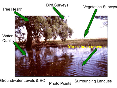 This image shows some of the parameters regularly measured to determine wetland condition as part of the Environmental Monitoring Program |
As well as through the Victorian Resources Online website – information from the project is disseminated via Annual Reports, visual presentations, field days and displays.
For further details contact:
Leah Thompson (Dryland) on (03) 5430 4444 or Leah.Thompson@dpi.vic.gov.au
Hamish Downs (Irrigation) on (03) 5450 9524 or Hamish.Downs@dpi.vic.gov.au
© State of Victoria (Agriculture Victoria) 1996 - 2025.

This work, Victorian Resources Online, is licensed under a Creative Commons Attribution 4.0 licence. You are free to re-use the work under that licence, on the condition that you credit the State of Victoria (Agriculture Victoria) as author, indicate if changes were made and comply with the other licence terms.
The licence does not apply to ‘branding’ or some ‘images or photographs’ that may be owned by third parties. We ask you to seek prior approval to use images using the VRO feedback form. Access to higher quality images can also be provided on request.
This page was last updated on 23/03/2020.