
Land Degradation
| Land Degradation in Victoria | Land Degradation McHugh's Gully | Eppalock Catchment Project |
Potential land degradation in North Central is mainly from water erosion, including sheet, gully, tunnel and deposition, while wind erosion types include sheet and deposition. Susceptibilities are scored from zero to three and then rated to give an erosion potential of nil, low, moderate or high. A class of nil indicates that the susceptibility is predicted to be generally below the limits of detection, and thus comparable to degradation under pre-European conditions. Measurement and description of relevant parameters follows McDonald at al (1990). Data on diagnostic characteristics are generally sufficient for broad predictions of susceptibility. Predictions based on chemical data are less reliable than physical data, and are tentative in areas without laboratory data for soils. Data on soil mottling are also unreliable (Rees, 2000).
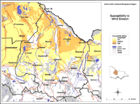
Wind Erosion
In the drier areas of North Central, particularly the north, fine pieces of soil largely of clay, silt and very fine sand particles tend to be removed in dust storms. This leaves medium to coarse sand particles behind. Sand surfaces in semi-arid areas of the catchment are weakly coherent and are particularly unstable when sparsely vegetated. However, susceptibility ratings in North Central are generally low, especially in the southern and central parts of the region. There is moderate susceptibility in parts of the north and in swamps in the far west of the catchment.
Significant wind erosion in the drier parts of Victoria is usually confined to cropping areas in the Mallee and northern Wimmera. However, in the 1982/83 drought, instability extended to sub-humid areas with up to 600 mm mean annual rainfall and included traditional grazing areas with little history of cultivation. Erosion may be severe during drought, but susceptibility is rated between nil to medium because of their intermittent occurrence in this region (Rees, 2000).
| The Susceptibility to Wind Erosion map is intended to be used with existing Land Systems data to determine the likely impact of wind erosion for areas within the catchment region. Criterion is based on Lorimer (1985) and uses surface texture in semi-arid to sub-humid areas and exposure to particularly strong winds in humid areas. The criterion for susceptibility to wind erosion in semi-arid areas is surface soil texture. Scores are given to rate texture from nil to high. |
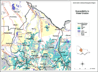
Water Erosion
| Most areas within North Central have nil, low or moderate susceptibility to water erosion. Those areas with low susceptibility are generally plains above flood level with grassy woodlands and broadacre cropping and cropping/pasture land use. These are quite extensive areas throughout the north of the catchment area and smaller patches of land in the southern half of the region. Those areas in the North Central region which are likely to have low to moderate susceptibility to water erosion are generally grassland plains above flood level whose chief land uses are broadacre cropping and dryland pasture. | 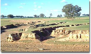 Gully erosion. |
There are small patches in the region which are prone to water erosion. These are said to have high susceptibility. Such areas run between the Charlton, Wedderburn and St Arnaud triangle, while other small areas south of Bealiba and Avoca are also at high risk to water erosion. Most of these areas were once characterised by Box-Ironbark and/ or Herb-rich woodlands but extensive areas have since been cleared of such vegetation. Land use types in these high risk areas are mostly public land and surrounds, with small patches being used for dryland pasture.
| The Susceptibility to Water Erosion map is intended to be used with existing Land Systems data to determine the likely impact of wind erosion for areas within the catchment region. Measurement is based on McDonald at al (1990) and uses soil depth (the average depth to solid rock). Rating scores are based on observations in hilly sub-humid areas where water erosion is relatively severe. These scores are rated from nil to high. |
References:
Lorimer, M.S., (1985). Estimating the susceptibility of soil to wind erosion in Victoria, Journal of Australian Institute for Agricultural Science, 51 (2), 122-127.
McDonald, R.C., Isbell, R.F., Speight, J.G., Walker, J., and Hopkins, M.S., (1990). Australian Soil and Land Survey Field Handbook, second edn., Inkata Press, Melbourne.
Rees, D., (2000). Land Systems of Victoria, 3rd edn., Centre for Land Protection Research Technical Report No. 56.
© State of Victoria (Agriculture Victoria) 1996 - 2025.

This work, Victorian Resources Online, is licensed under a Creative Commons Attribution 4.0 licence. You are free to re-use the work under that licence, on the condition that you credit the State of Victoria (Agriculture Victoria) as author, indicate if changes were made and comply with the other licence terms.
The licence does not apply to ‘branding’ or some ‘images or photographs’ that may be owned by third parties. We ask you to seek prior approval to use images using the VRO feedback form. Access to higher quality images can also be provided on request.
This page was last updated on 23/03/2020.