
Slide 3D
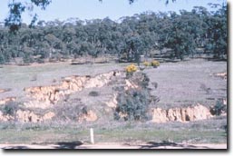 | This is a closer view of the finger gullying seen in 2A. It is easy to see how this form of erosion can create access problems for landholders. The forest behind the fingering was contour furrowed in the early 1960s. It was designed to reduce runoff. However, as a result of this it also increased sub surface flow of water which destabilised the gully sides. The soil here would break down quite easily in water. It is poorly structured with low cohesion. Deep rilling is clearly evident. |
© State of Victoria (Agriculture Victoria) 1996 - 2025.

This work, Victorian Resources Online, is licensed under a Creative Commons Attribution 4.0 licence. You are free to re-use the work under that licence, on the condition that you credit the State of Victoria (Agriculture Victoria) as author, indicate if changes were made and comply with the other licence terms.
The licence does not apply to ‘branding’ or some ‘images or photographs’ that may be owned by third parties. We ask you to seek prior approval to use images using the VRO feedback form. Access to higher quality images can also be provided on request.
This page was last updated on 23/03/2020.