
Slide 6A
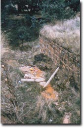 | This structure was built in the late 1950s by the Shire of Talbot and Clunes. It was designed to safely direct flows of water into the gully and thus control erosion. Soon it was threatened by erosion itself and the Shire asked for help from the Soil Conservation Authority. The catchment was contour furrowed, structures were built, water was diverted to safe places and trees were planted. |
© State of Victoria (Agriculture Victoria) 1996 - 2025.

This work, Victorian Resources Online, is licensed under a Creative Commons Attribution 4.0 licence. You are free to re-use the work under that licence, on the condition that you credit the State of Victoria (Agriculture Victoria) as author, indicate if changes were made and comply with the other licence terms.
The licence does not apply to ‘branding’ or some ‘images or photographs’ that may be owned by third parties. We ask you to seek prior approval to use images using the VRO feedback form. Access to higher quality images can also be provided on request.
This page was last updated on 23/03/2020.