
Landform
|
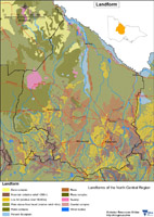
The area is enclosed within the Victorian Riverina and adjoins the Murray River. In the lower catchment (north of the Great Dividing Range) lies the Goldfields, which are dominated by rolling plains and hills. From the landform map below, the majority of the North Central catchment region is comprised of plains above flood level with a relative relief below 9 metres. This area encompasses most of the north-east of the catchment and large sub-regions throughout the remainder. | 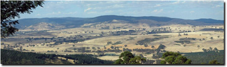 View of Pyrenees Range (from Mt Cole) |
Other significant land formations in North Central include various hills and rises. The relative relief of most of these hills are 90 to 300 metres, while the rises are between 9-30 metres. These rises also encompass stranded beach ridges which usually trend in a NNW-SSE direction. Hills and rises interlock between the plains, chiefly throughout the lower catchment region.
Moving from east to west in the catchment region, landform changes from the above mentioned plains, hills and rises characteristics to a mixture of inland dunes, plains above flood level with a relative relief of up to 9 metres and rises with a relative relief of 9 to 30 metres (including stranded beach ridges which usually trend NNW-SSE). There are also swamps, lunettes and other water body complexes in the far west of the region. Finally, a significant floodplain bisects east from west in the upper catchment region.
A specific study of landform and soil relationships was carried out in the Bet Bet Creek catchment.
This broadscale Landform map provides an overview of the distribution of major landforms across the North Central region. |
Geology Information
Geoscience Victoria's web mapping application allows users to search geospatial databases and display the results as maps or tables. Datasets that can be viewed and interrogated include mineral, petroleum and extractive industries tenements, land-use and airborne geophysical survey boundaries, gravity, magnetic and radiometric images, bore hole & well data, surface geochemistry results, mines and mineral occurrences, and geological maps and interpretations at various scales.
© State of Victoria (Agriculture Victoria) 1996 - 2025.

This work, Victorian Resources Online, is licensed under a Creative Commons Attribution 4.0 licence. You are free to re-use the work under that licence, on the condition that you credit the State of Victoria (Agriculture Victoria) as author, indicate if changes were made and comply with the other licence terms.
The licence does not apply to ‘branding’ or some ‘images or photographs’ that may be owned by third parties. We ask you to seek prior approval to use images using the VRO feedback form. Access to higher quality images can also be provided on request.
This page was last updated on 26/04/2021.