
Soil/Landform Unit - Lillimur South clay plains
 Lillimur South clay plains |
0.54% of CMA region Clay plains south and east of Servicetown are recognised for the grey and brown cracking clay soils (Vertosols) that are often self-mulching. Gentle subdued rises with sodic red texture contrast soils (Sodosols) also occur as part of former stranded beach ridges that have minor occurrences of superimposed dunes. As part of the ridges with sand, and flats geomorphology sequence (5.5.1), this soil-landform unit occurs on the northern boundary of the Little Desert. Cereal cropping is the major land use with vegetation communities including Ridged Plains Mallee, Plains Grassland and Plains Savannah found mostly on clay soils and plains. Shallow Sand Woodland is found on lunettes or sandy soils and Red Gum Wetland, Lignum Swampy Woodland and Seasonally Inundated Shrubby Woodland found in wetter areas of the landscape. Low Rises Woodland has also been recorded. | 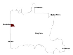 |
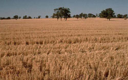
 Valley flat selectively cleared and used for cropping | 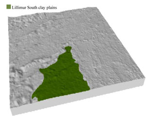 |
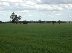
 | 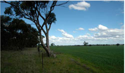 Remnant vegetation and cereal crop |
Component | 1 | 2 | 3 | 4 | 5 |
Proportion of soil-landform unit | 5% | 10% | 20% | 10% | 55% |
| CLIMATE Rainfall (mm) | Annual: 485 | ||||
| Temperature (oC) | Minimum 8, Maximum 22 | ||||
| Precipitation less than potential evapotranspiration | September–April | ||||
| GEOLOGY Age and lithology | Quaternary paludal silt and clay | ||||
| Geomorphology | |||||
| LANDUSE | Uncleared areas: Nature conservation Cleared areas: Dryland cropping; sheep grazing | ||||
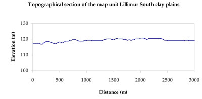
| TOPOGRAPHY Landscape | Clay plains | ||||
| Elevation range (m) | 110–138 | ||||
| Local relief (m) | 2 | ||||
| Drainage pattern | Dendritic | ||||
| Drainage density (km/km2) | 0.1 | ||||
| Landform | Rises | Plains | |||
| Landform element | Rise crest | Rise slope | Drainage line | Swale | Plain |
| Slope and range (%) | 3 (1-8) | 4 (1-8) | 2 (1-4) | 1 (0-4) | 1 (0-3) |
| Slope shape | Convex | Convex | Concave | Concave | Straight |
| NATIVE VEGETATION Ecological Vegetation Class | Low Rises Woodland (30.6%), Ridged Plains Mallee (22.9%), Plains Savannah (18.6%), Shallow Sands Woodland (12.4%), Other (14.0%) | ||||
| SOIL Parent material | Marine sand and silt, aeolian sand | Marine sand and silt, aeolian sand | Paludal silt and clay | Paludal silt and clay, marine sand and silt | Paludal silt and clay |
| Description (Corangamite Soil Group) | Sodic red texture contrast soils (35) | Sodic red texture contrast soils (35) | Grey and brown cracking clay soils (37) | Grey and brown cracking clay soils (37) | Grey and brown cracking clay soils (37) |
| Soil type sites | LS3, LSWW9, LSWW5 | LS3, LSWW9, LSWW5 | LS3, LSWW9, LSWW5 | ||
| Surface texture | Sandy clay loam | Sandy clay loam | Medium clay | Medium clay | Medium clay |
| Permeability | Moderate | Moderate | Slow to very slow | Slow | Slow |
| Depth (m) | 1.6 | 2 | > 2 | > 2 | > 2 |
| LAND CHARACTERISTICS, POTENTIAL AND LIMITATIONS Critical land features, processes, forms | Hardsetting soil surface susceptible to sheet and rill erosion, and wind erosion where exposed. Dispersive and deep subsoils susceptible to gully erosion on steeper slopes. Compaction of soil dependent upon depth of force and moisture content. Topsoil may be susceptible to acidification. | Hardsetting soil surface susceptible to sheet and rill erosion, and wind erosion where exposed. Dispersive and deep subsoils susceptible to gully erosion on steeper slopes. Compaction of soil dependent upon depth of force and moisture content. | Susceptible to seasonal inundation and waterlogging. Surface soils friable and only slightly susceptible to wind erosion. Soils susceptible to compaction at critical moisture contents. | Susceptible to periodic inundation and waterlogging in lower areas, but can be variable due to micro relief (gilgai). Gully erosion can occur where dispersive subsoils are exposed. Surface soils friable and only slightly susceptible to wind erosion. Soils susceptible to compaction at critical moisture contents. | Susceptible to inundation and waterlogging in lower areas, but can be variable due to micro relief (gilgai). Slightly susceptible to surface sheet erosion where soils are exposed. Soils susceptible to compaction at critical moisture contents. |
© State of Victoria (Agriculture Victoria) 1996 - .

This work, Victorian Resources Online, is licensed under a Creative Commons Attribution 4.0 licence. You are free to re-use the work under that licence, on the condition that you credit the State of Victoria (Agriculture Victoria) as author, indicate if changes were made and comply with the other licence terms.
The licence does not apply to ‘branding’ or some ‘images or photographs’ that may be owned by third parties. We ask you to seek prior approval to use images using the VRO feedback form. Access to higher quality images can also be provided on request.
This page was last updated on .