
Soil/Landform Unit - Lorquon undulating plains
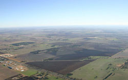 Lorquon plains north of Nhill |
3.34% of CMA region Gently undulating plains north of the Little Desert and south of the Big Desert include a complex of plains and low gentle terrain between NNW-SSE trending rises and low hills. Slopes are generally less that 3% with parent material largely a combination of fluvial and aeolian deposits. Uniform grey and brown clays (Vertosols) predominate with sodic red, brown, yellow and grey texture contrast soils (Sodosols) found mainly in higher topographic positions than those of the clays. The clays may experience periodic waterlogging in lower areas during wet seasons but this is relatively infrequent. All soils may be susceptible to compaction at critical moisture contents. Cereal cropping and grazing are major land uses. Plains Savannah and Ridged Plains Mallee are the most expansive remnant vegetation communities. Areas of other vegetation communities such as Lignum Swampy Woodland, Plains Woodland, Sandstone Ridge Shrubland, Shallow Sands Woodland, Parilla Mallee, Low Rises Woodland and Heathy Mallee are also found. |  |
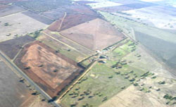
 Cultivated plains with a stranded beach ridge rise in the distance |  |
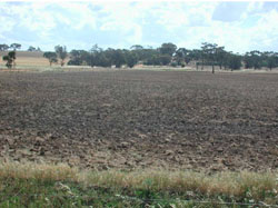
 |  Cultivated paddock near Lawloit |
Component | 1 | 2 | 3 |
Proportion of soil-landform unit | 5% | 80% | 15% |
| CLIMATE Rainfall (mm) | Annual: 430 | ||
| Temperature (oC) | Minimum 8, Maximum 22 | ||
| Precipitation less than potential evapotranspiration | September–April | ||
| GEOLOGY Age and lithology | Quaternary paludal silt and clay; Quaternary aeolian dune sand (Lowan Sand); Neogene marine sand and silt (Parilla Sand) | ||
| Geomorphology | |||
| LANDUSE | Uncleared areas: nature conservation Cleared areas: dryland cropping; sheep grazing | ||
| TOPOGRAPHY Landscape | Gently undulating plains | ||
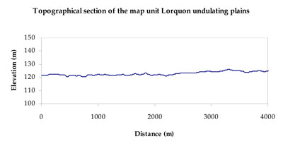
| Elevation range (m) | 99–179 | ||
| Local relief (m) | 1–2 | ||
| Drainage pattern | Dendritic | ||
| Drainage density (km/km2) | 0.1 | ||
| Landform | Gently undulating plains | ||
| Landform element | Low rise crest | Broad gentle plain | Low rise slope |
| Slope and range (%) | 4 (1-7) | 1 (0-2) | 3 (2-7) |
| Slope shape | Convex | Straight | Linear |
| NATIVE VEGETATION Ecological Vegetation Class | Ridged Plains Mallee (27.5%), Plains Savannah (25.3%), Low Rises Woodland (17.3%), Plains Woodland (10.5%), Other (17.2%) | ||
| SOIL Parent material | Marine sand and silt, aeolian sand | Paludal silt and clay | Marine sand and silt, aeolian sand |
| Description (Corangamite Soil Group) | Sodic red texture contrast soils (35) | Grey and brown cracking clay soils (37) | Sodic brown, yellow and grey texture contrast soils (36) |
| Soil type sites | LS3, LSWW9, LSWW5 | ||
| Surface texture | Sandy clay loam | Medium clay | Sandy clay loam |
| Permeability | Moderate | Slow | Slow |
| Depth (m) | 1.6 | > 2 | > 2 |
| LAND CHARACTERISTICS, POTENTIAL AND LIMITATIONS Critical land features, processes, forms | Hardsetting soil surface (weakly structured) susceptible to sheet and rill erosion, and wind erosion where exposed. Dispersive and deep subsoils susceptible to gully erosion on steeper slopes. Topsoil may be susceptible to acidification. | Susceptible to inundation and waterlogging in lower areas, but can be variable due to micro relief (gilgai). Slightly susceptible to surface sheet erosion where soils are exposed. Surface soils friable and only slightly susceptible to wind erosion. Soils susceptible to compaction at critical moisture contents. | Susceptible to wind and sheet erosion where exposed. Low inherent soil fertility in well drained surface soil abruptly over structured subsoil. Susceptible to compaction where hardsetting with restricted drainage. |
© State of Victoria (Agriculture Victoria) 1996 - .

This work, Victorian Resources Online, is licensed under a Creative Commons Attribution 4.0 licence. You are free to re-use the work under that licence, on the condition that you credit the State of Victoria (Agriculture Victoria) as author, indicate if changes were made and comply with the other licence terms.
The licence does not apply to ‘branding’ or some ‘images or photographs’ that may be owned by third parties. We ask you to seek prior approval to use images using the VRO feedback form. Access to higher quality images can also be provided on request.
This page was last updated on .