
Soil/Landform Unit - Woorak clay plains
Landform Unit Description
Page top
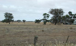
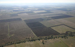 Looking north over cultivated clay plains near Woorak |
2.38% of CMA region The plains (including swales) and low rises consists of many linear occurrences north of the Little Desert, east and west of Nhill and south of the Big Desert. This low plain complex is part of the North West Dunefields and Plains. These plains of Quaternary lacustrine and aeolian sediments are part of a NNW/SSE orientated terrain surrounded by associated rises/ridges and other ridge/depression units (Kiata, Diapur, Lorquon). There are three components including level plains, gently undulating plains and low gentle rises. Drainage is strongly aligned to the terrain with little surface expression apart from local depressions, including swamps and lakes. Soil types are predominantly grey cracking clay soils (Vertosols) on plains and in local depressions, and brown and red sodic texture contrast soils (Sodosols) on the gentle rises. Waterlogging may be an issue in the depressions and extensive flat areas during wet seasons. Soil compaction may occur on heavier soils with or without thin topsoils. This unit is used for dryland cropping and grazing (sheep, beef cattle). Plains Savannah, Ridged Plains Mallee and Low Rises Woodland dominate remnant vegetation. | 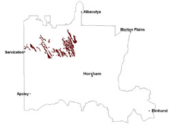 |
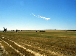 Cropped clay plains near Gerang Gerang | 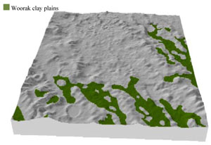 |
 |  Plains with remnant bulloke |
Component | 1 | 2 | 3 |
Proportion of soil-landform unit | 20% | 50% | 30% |
| CLIMATE Rainfall (mm) | Annual: 435 | ||
| Temperature (oC) | Minimum 8, Maximum 22 | ||
| Precipitation less than potential evapotranspiration | September–April | ||
| GEOLOGY Age and lithology | Quaternary paludal silt and clay; Neogene marine sand and silt (Parilla Sand); Quaternary aeolian dune sand (Lowan Sand) | ||
| Geomorphology | |||
| LANDUSE | Uncleared areas: nature conservation Cleared areas: dryland cropping; sheep and beef cattle grazing | ||
| TOPOGRAPHY Landscape | Clay plains | ||
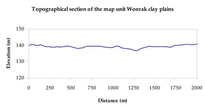
| Elevation range (m) | 92–207 | ||
| Local relief (m) | 3 | ||
| Drainage pattern | Dendritic | ||
| Drainage density (km/km2) | 0.3 | ||
| Landform | Plains | ||
| Landform element | Low gentle rise | Level plain | Gently undulating plain |
| Slope and range (%) | 4 (1-7) | 0 (0-1) | 2 (1-5) |
| Slope shape | Convex | Straight | Straight |
| NATIVE VEGETATION Ecological Vegetation Class | Plains Savannah (29.5%), Ridged Plains Mallee (27.6%), Low Rises Woodland (14.8%), Lignum Swampy Woodland (10.0%), Other (16.0%) | ||
| SOIL Parent material | Marine sand and silt, aeolian sand | Marine sand and silt | Marine sand and silt |
| Description (Corangamite Soil Group) | Sodic red texture contrast soils (35) | Grey and brown cracking clay soils (37) | Grey and brown cracking clay soils (37) |
| Soil type sites | LS3, LSWW9, LSWW5 | LS3, LSWW9, LSWW5 | |
| Surface texture | Sandy clay loam | Medium clay | Medium clay |
| Permeability | Moderate | Slow | Slow |
| Depth (m) | 1.6 | > 2 | > 2 |
| LAND CHARACTERISTICS, POTENTIAL AND LIMITATIONS Critical land features, processes, forms | Hardsetting soil surface susceptible to sheet and rill erosion, and wind erosion where exposed. Dispersive and deep subsoils susceptible to gully erosion on steeper slopes. Hardsetting soils are prone to compaction. Topsoil may be susceptible to acidification. | Susceptible to periodic inundation and waterlogging in lower areas, but can be variable due to micro relief (gilgai). Surface soils are often friable and only slightly susceptible to wind erosion. Soils susceptible to compaction at critical moisture contents. | Susceptible to periodic inundation and waterlogging in lower areas, but can be variable due to micro relief (gilgai). Surface soils are often friable and only slightly susceptible to wind erosion. Soils susceptible to compaction at critical moisture contents. |
© State of Victoria (Agriculture Victoria) 1996 - .

This work, Victorian Resources Online, is licensed under a Creative Commons Attribution 4.0 licence. You are free to re-use the work under that licence, on the condition that you credit the State of Victoria (Agriculture Victoria) as author, indicate if changes were made and comply with the other licence terms.
The licence does not apply to ‘branding’ or some ‘images or photographs’ that may be owned by third parties. We ask you to seek prior approval to use images using the VRO feedback form. Access to higher quality images can also be provided on request.
This page was last updated on .