
Soil/Landform Unit - Broughton undulating plains
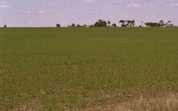 Gently Undulating Plains with Red Sodosols dominant (note the grey surface soil of Grey Vertosol in foreground. Red Sodosols occur on low rises. |
0.29% of CMA region Undulating plains near Broughton in the north-west of the Wimmera CMA region form part of the prominent ridges and oriented swales of the North West Dunefields and Plains (5.5.1). Characterised by gentle slopes and flats, the plains are characterised by sodic red texture contrast soils on the slopes where they have hardsetting surfaces that are susceptible to sheet and rill erosion, and wind erosion where exposed. Grey to brown cracking soils on the flats (swales) between ridges suffer from periodic inundation and waterlogging but this can be variable due to micro relief (gilgai). Soils may be susceptible to compaction at critical moisture contents. Land use is primarily dryland cropping with grazing by sheep and cattle less prominent today. The main remnant vegetation communities include Low Rises Woodland, Ridged Plains Mallee, Plains Grassland, Plains Woodland and Plains Savannah. | 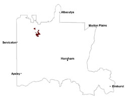 |
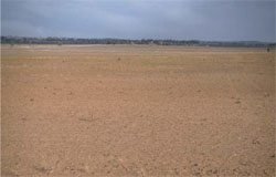 Gently undualting plain with Buloke (C. leuhmanni) | 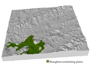 |
| 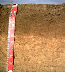 Sodic red brown earth |
Component | 1 | 2 | 3 |
Proportion of soil-landform unit | 15% | 45% | 40% |
| CLIMATE Rainfall (mm) | Annual: 410 | ||
| Temperature (oC) | Minimum 8, Maximum 22 | ||
| Precipitation less than potential evapotranspiration | September–April | ||
| GEOLOGY Age and lithology | Neogene marine sand and silt (Parilla Sand); Quaternary paludal silt and clay (Lowan Sand); Quaternary aeolian dune sand | ||
| Geomorphology | |||
| LANDUSE | Uncleared areas: nature conservation Cleared areas: dryland cropping; sheep grazing | ||
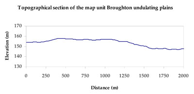
| TOPOGRAPHY Landscape | Gently undulating plains | ||
| Elevation range (m) | 102–172 | ||
| Local relief (m) | 2–3 | ||
| Drainage pattern | Dendritic | ||
| Drainage density (km/km2) | 0.4 | ||
| Landform | Plain | ||
| Landform element | Upper mid to moderate slopes | Low gentle slopes | Flat |
| Slope and range (%) | 3 (2-10) | 1 (1-4) | 0 (0-1) |
| Slope shape | Concave | Linear | Straight |
| NATIVE VEGETATION Ecological Vegetation Class | Ridged Plains Mallee (31.5%), Low Rises Woodland (24.8%), Plains Woodland (21.6%), Plains Savannah (12.8%), Other (8.8%) | ||
| SOIL Parent material | Aeolian dune sand | Aeolian dune sand | Aeolian sand and silt, swamp deposits |
| Description (Corangamite Soil Group) | Sodic red texture contrast soils (35) | Sodic red texture contrast soils (35) | Grey and brown cracking clay soils (37) |
| Soil type sites | LS3, LSWW9, LSWW5 | ||
| Surface texture | Sandy clay loam | Sandy clay loam | Medium clay |
| Permeability | Moderate | Moderate | Slow |
| Depth (m) | 1.6 | 1.6 | > 2 |
| LAND CHARACTERISTICS, POTENTIAL AND LIMITATIONS Critical land features, processes, forms | Weakly structured soil surface (hardsetting) is susceptible to sheet and rill erosion, and wind erosion where exposed. Dispersive and deep subsoils susceptible to gully erosion on steeper slopes. Compaction of soil dependent upon depth of force and moisture content. Subsoils are highly sodic and saline. | Weakly structured soil surface (hardsetting) is susceptible to sheet and rill erosion, and wind erosion where exposed. Dispersive and deep subsoils susceptible to gully erosion on steeper slopes. Compaction of soil dependent upon depth of force and moisture content. Subsoils are highly sodic and saline. | Susceptible to inundation and waterlogging in lower areas, but can be variable due to micro relief (gilgai). Slightly susceptible to surface sheet erosion where soils are exposed. Surface soils are friable and only slightly susceptible to wind erosion. Soils susceptible to compaction at critical moisture contents. |
© State of Victoria (Agriculture Victoria) 1996 - .

This work, Victorian Resources Online, is licensed under a Creative Commons Attribution 4.0 licence. You are free to re-use the work under that licence, on the condition that you credit the State of Victoria (Agriculture Victoria) as author, indicate if changes were made and comply with the other licence terms.
The licence does not apply to ‘branding’ or some ‘images or photographs’ that may be owned by third parties. We ask you to seek prior approval to use images using the VRO feedback form. Access to higher quality images can also be provided on request.
This page was last updated on .