
Soil/Landform Unit - Wail parabolic dunes
Landform Unit Description
Page top
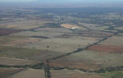 Looking south towards Dimboola and dunes to its south |
0.14% of CMA region Dunes and sand plains south of Dimboola are part of a siliceous dunefield complex within the North West Dunefields and Plains. This complex of Quaternary aeolian sediments in the form of parabolic dunes forms part of the Little Desert, but has been dissected by the Wimmera River and has sharp boundaries with the clay plains to the east. There are four components with dune slopes dominant and dune crests sub-dominant. Sandy soils (with and without pans) are mainly found on dunes with brown, yellow and grey sodic texture contrast soils (Sodosols) common on plains and in local depressions. Wind erosion is a local threat where topsoils are light textured and exposed. This unit is used for nature conservation and grazing (sheep, beef cattle). Vegetation consists of a range of woodland, heathland and mallee vegetation including Shallow Sands Woodland, Riparian Woodland, Riverine Chenopod Woodland, Dunefield heathland, Lowan Sands Mallee and Low Rises Woodland. Plains Savannah has also been recorded. | 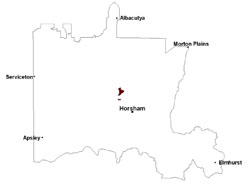 |
 Suimple slopes and parabolic dunes near Wail covered with native vegetation | 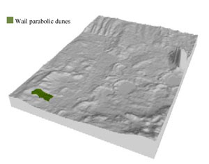 |
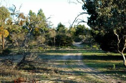
 | 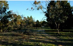 Nature trail across parabolic dune |
Component | 1 | 2 | 3 | 4 |
Proportion of soil-landform unit | 25% | 60% | 10% | 5% |
| CLIMATE Rainfall (mm) | Annual: 420 | |||
| Temperature (oC) | Minimum 8, Maximum 22 | |||
| Precipitation less than potential evapotranspiration | September–April | |||
| GEOLOGY Age and lithology | Neogene marine sand and silt (Parilla Sand); Quaternary aeolian dune sand (Lowan Sand); Quaternary alluvium, gravel, sand and silt | |||
| Geomorphology | ||||
| LANDUSE | Uncleared areas: nature conservation Cleared areas: sheep and beef cattle grazing | |||
| TOPOGRAPHY Landscape | Parabolic dunes | |||
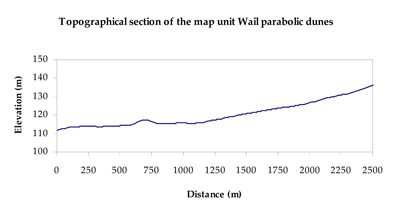
| Elevation range (m) | 104–156 | |||
| Local relief (m) | 5 | |||
| Drainage pattern | Deranged | |||
| Drainage density (km/km2) | 0.1 | |||
| Landform | Dunefields | Plains | ||
| Landform element | Dune crest | Dune slope | Level plain | Playa |
| Slope and range (%) | 3 (2-6) | 2 (1-5) | 1 (0-3) | 1 (0-2) |
| Slope shape | Convex | Linear | Straight | Concave |
| NATIVE VEGETATION Ecological Vegetation Class | Dunefield Heathland (43.7%), Low Rises Woodland (26.4%), Shallow Sands Woodland (12.7%), Riverine Chenopod Woodland (7.6%), Other (8.8%) | |||
| SOIL Parent material | Aeolian dune sand | Aeolian dune sand | Marine sand and silt | Paludal sand and silt, alluvial gravel, sand and silt |
| Description (Corangamite Soil Group) | Sandy soils with and without pans (31) and sodic yellow and grey texture contrast soils (32) | Sandy soils with and without pans (31) and sodic yellow and grey texture contrast soils (32) | Sodic yellow and grey texture contrast soils (32) | Seasonally wet soils: sodic yellow and grey texture contrast soils (33) |
| Soil type sites | ||||
| Surface texture | Loamy sand | Loamy sand | Loamy sand | Sand |
| Permeability | High | High | Slow | Slow |
| Depth (m) | > 1.5 | > 1.5 | > 1.5 | > 1.5 |
| LAND CHARACTERISTICS, POTENTIAL AND LIMITATIONS Critical land features, processes, forms | Soils with low organic matter levels can be susceptible to wind and sheet erosion where exposed. Low inherent soil fertility. | Soils with low organic matter levels can be susceptible to wind and sheet erosion where exposed. Low inherent soil fertility. | Susceptible to wind and sheet erosion where exposed. Low inherent fertility but well drained to pans or subsoil. Susceptible to compaction where hardsetting and poor drainage occurs. | Susceptible to seasonal inundation, waterlogging and ultimately soil salinity. Upper soils susceptible to sheet erosion and wind erosion when exposed. |
© State of Victoria (Agriculture Victoria) 1996 - .

This work, Victorian Resources Online, is licensed under a Creative Commons Attribution 4.0 licence. You are free to re-use the work under that licence, on the condition that you credit the State of Victoria (Agriculture Victoria) as author, indicate if changes were made and comply with the other licence terms.
The licence does not apply to ‘branding’ or some ‘images or photographs’ that may be owned by third parties. We ask you to seek prior approval to use images using the VRO feedback form. Access to higher quality images can also be provided on request.
This page was last updated on .