
Soil/Landform Unit - Little Desert linear dunes
 Little Desert linear dunes |
1.93% of CMA region Within central areas of the Little Desert, a sequence of east-west dunes (linear dunes) have formed. The dunes comprise Lowan Sand that is thought to originate from deflation of underlying Parilla Sand as remnant stranded beach ridges. Running east-west, the Little Desert is relatively uncleared owing to the high concentration of sands and low inherent fertility. Major soils across the dunes and plains include sodic yellow and grey texture contrast soils (Sodosols) with deep sandy topsoils, and deep sandy profile also prominent on dune crests. Given the high concentration of sands across the dunes and plains, wind erosion is the major land degradation threat owing to the relatively incoherent nature of these sands. Vegetation includes a range of woodland, heathland, shrubland and mallee vegetation. Communities recorded include Shallow Sands Woodland, Plains Woodland, Damp Heathland, Sandstone Ridge Shrubland, Dunefield Heathland, Lowan Sands Mallee and Low Rises Woodland. Red Gum Wetland and Seasonally Inundated Shrubby Woodland have also been found in wetter areas of the landscape. | 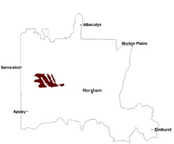 |
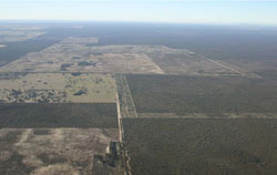
 Cultivated east-west dunes near the Kaniva-Edenhope Road | 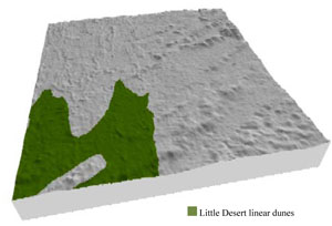 |
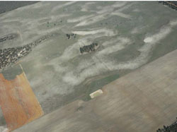
 | 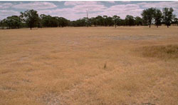 Sand plains on the northern margin of the Little Desert |
Component | 1 | 2 | 3 |
Proportion of soil-landform unit | 15% | 50% | 35% |
| CLIMATE Rainfall (mm) | Annual: 500 | ||
| Temperature (oC) | Minimum 8, Maximum 21 | ||
| Precipitation less than potential evapotranspiration | September–April | ||
| GEOLOGY Age and lithology | Neogene marine sand and silt (Parilla Sand); Quaternary paludal silt and clay; Quaternary aeolian dune sand (Lowan Sand) | ||
| Geomorphology | 5.2.2 Linear dunes of the Siliceous North West Dunefields and Plains | ||
| LANDUSE | Uncleared areas: nature conservation Cleared areas: dryland cropping; sheep grazing | ||
| TOPOGRAPHY Landscape | Linear east west dunes | ||
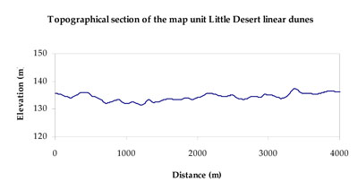
| Elevation range (m) | 127–193 | ||
| Local relief (m) | 5–10 | ||
| Drainage pattern | - | ||
| Drainage density (km/km2) | - | ||
| Landform | Dunes | ||
| Landform element | Dune crest | Dune slope | Sand plain |
| Slope and range (%) | 4 (1-20) | 7 (3-25) | 2 (0-8) |
| Slope shape | Convex | Convex | Straight |
| NATIVE VEGETATION Ecological Vegetation Class | Lowan Sands Mallee (39.5%), Shallow Sands Woodland (21.3%), Dunefield Heathland (16.1%), Sandstone Ridge Shrubland (9.3%), Other (13.7%) | ||
| SOIL Parent material | Aeolian sand | Aeolian sand | Aeolian sand, marine sand and silt |
| Description (Corangamite Soil Group) | Sandy soils with and without pans (31) | Sodic yellow and grey texture contrast soils (32) | Sodic yellow and grey texture contrast soils (32) |
| Soil type sites | |||
| Surface texture | Sand | Loamy sand | Loamy sand |
| Permeability | High | Slow | Slow |
| Depth (m) | > 1.5 | > 1.5 | > 1.5 |
| LAND CHARACTERISTICS, POTENTIAL AND LIMITATIONS Critical land features, processes, forms | Soils with low organic matter levels can be susceptible to wind and sheet erosion where exposed. Low inherent soil fertility. | Susceptible to wind and sheet erosion where exposed. Low inherent fertility but well drained to pans or subsoil. Susceptible to compaction where hardsetting and lower slopes occurs. | Susceptible to wind and sheet erosion where exposed. Low inherent fertility. Susceptible to compaction where hardsetting and poor drainage occurs. |
© State of Victoria (Agriculture Victoria) 1996 - .

This work, Victorian Resources Online, is licensed under a Creative Commons Attribution 4.0 licence. You are free to re-use the work under that licence, on the condition that you credit the State of Victoria (Agriculture Victoria) as author, indicate if changes were made and comply with the other licence terms.
The licence does not apply to ‘branding’ or some ‘images or photographs’ that may be owned by third parties. We ask you to seek prior approval to use images using the VRO feedback form. Access to higher quality images can also be provided on request.
This page was last updated on .