
Soil/Landform Unit - Big Desert jumbled dunes
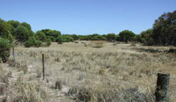
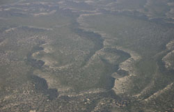 Jumbled dunes of the Big Desert |
2.04% of CMA region The Big Desert forms a significant part of the North West Dunefields and Plains of Victoria with large surfaces of Lowan Sand dominated by dune formations. The jumbled dunes comprise fine aeolian sands with dunes complex and orientated on various axis. Often large (higher relief that the linear dunes) with sharp crests, plains are intermixed and scattered amongst a confused topography. The area is dominated by woodland and mallee vegetation communities including Shallow Sands Woodland, Sandstone Ridge Shrubland, Heathy Mallee and Lowan Sands Mallee. Lining the north-western extent of the Wimmera CMA region, soils comprise sandy soils with negligible pedological development except on plains and swales where sodic soils with deep sandy surfaces can be found. Soils have a very low inherent soil fertility owing to their high sand content and dune crests are especially vulnerable to wind erosion. | 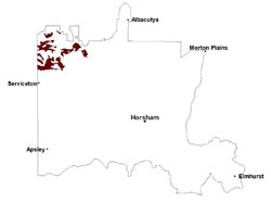 |
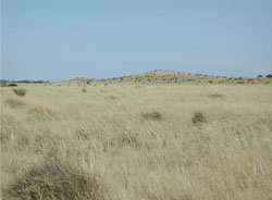 Dunefield with sand plains and jumbled dunes | 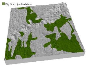 |
|
|
Component | 1 | 2 | 3 |
Proportion of soil-landform unit | 20% | 60% | 20% |
| CLIMATE Rainfall (mm) | Annual: 420 | ||
| Temperature (oC) | Minimum 8, Maximum 22 | ||
| Precipitation less than potential evapotranspiration | September–April | ||
| GEOLOGY Age and lithology | Quaternary aeolian dune sand (Lowan Sand); Neogene marine sand and silt (Parilla Sand); Quaternary paludal silt and clay | ||
| Geomorphology | 5.2.1 Parabolic dunes of the Siliceous North West Dunefields and Plains | ||
| LANDUSE | Uncleared areas: nature conservation; recreational activities Cleared areas: dryland cropping; sheep grazing; native vegetation plantation/harvesting (e.g. broombush) | ||
| TOPOGRAPHY Landscape | Sand plain with jumbled dunes | ||
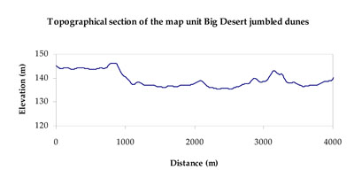
| Elevation range (m) | 104–166 | ||
| Local relief (m) | 10 | ||
| Drainage pattern | Absent | ||
| Drainage density (km/km2) | Nil | ||
| Landform | Dunefields | ||
| Landform element | Dune crest (steeper more dissected crests than BD1) | Dune slope (more steeply dissected than BD1) | Swale |
| Slope and range (%) | 5 (1-12) | 7 (3-20) | 3 (1-8) |
| Slope shape | Convex | Convex | Concave |
| NATIVE VEGETATION Ecological Vegetation Class | Lowan Sands Mallee (39.3%), Sandstone Ridge Shrubland (23.2%), Heathy Mallee (12.9%), Shallow Sands Woodland (12.3%), Low Rises Woodland (6.7%), Other (5.2%) | ||
| SOIL Parent material | Aeolian sand | Aeolian sand | Aeolian sand, silt and clay |
| Description (Corangamite Soil Group) | Sandy soils with and without pans (31) | Sodic yellow and grey texture contrast soils (32) | |
| Soil type sites | LSWW8, LSWW7, WIA24 | ||
| Surface texture | Sand | Sand | Loamy sand |
| Permeability | High | High | Moderate |
| Depth (m) | > 1.5 | > 1.5 | > 1.5 |
| LAND CHARACTERISTICS, POTENTIAL AND LIMITATIONS Critical land features, processes, forms | Soils with low organic matter levels can be susceptible to wind and sheet erosion where exposed. Low inherent soil fertility. | Soils with low organic matter levels that are highly susceptible to wind and sheet erosion where exposed. Low inherent soil fertility. | Susceptible to wind and sheet erosion where exposed. Low inherent fertility but well drained to pans or subsoil. Susceptible to compaction where hardsettingand poor drainage occurs. |
© State of Victoria (Agriculture Victoria) 1996 - .

This work, Victorian Resources Online, is licensed under a Creative Commons Attribution 4.0 licence. You are free to re-use the work under that licence, on the condition that you credit the State of Victoria (Agriculture Victoria) as author, indicate if changes were made and comply with the other licence terms.
The licence does not apply to ‘branding’ or some ‘images or photographs’ that may be owned by third parties. We ask you to seek prior approval to use images using the VRO feedback form. Access to higher quality images can also be provided on request.
This page was last updated on .