
Landform Glossary
AEOLIAN: Material that has been transported and deposited by wind.
BLANCHETOWN CLAY: Blanchetown Clay was deposited in an ancient large freshawater lake called Lake Bungunnia during the late Pliocene and early Pleistocene (2.5-3.5 million years ago - 0.7 million years ago, An et al 1986). These deposits consist mainly of red-brown and green mottled clays (usually vertic and sodic).
For more information go to Blanchetown Clay page
CAINOZOIC: Geological time period that groups a number of the recent epochs (i.e. Tertiary and Quaternary - approximately 65 million years ago (mya) - present) (Geological timechart).
CALCAREOUS: Used as a descriptive term in the Australian Soil Classification (Isbell, 1996). It describes a soil that has sufficient calcium carbonate to cause effervescence on the application of a few drops of hydrochloric acid.
CARBONIFEROUS: Geological time period of 360 to 290 million years ago. A number of sedimentary basins of this age occur in Victoria, where the red (purple) beds are a distinctive feature (Geological timechart).
CATENA: A sequence of soils of about the same age, derived from similar parent material and occurring under similar climatic conditions but having different characteristics due to variation in relief and in drainage (Glossary of Soil Science Terms - Soil Science Society America, 1973).
CHRONOSEQUENCE: A sequence of events over time.
CONTINUOUS GRADIENT TUNNELLING: A geomorphic situation where tunnel flow debouches through a free face such as provided by a gully wall (Boucher 1990).
CRETACEOUS: Geological time period which extended from approximately 145 million years ago to 65 million years ago.
DEBOUCH: When runoff emerges from a confined space onto a larger area.
DEVONIAN: Geological time period of approximately 405 to 360 million years ago. The majority of plutons (granitic masses) in Victoria are dated as Devonian (Geological timechart).
DIGITAL ELEVATION MODELS: Digital Elevation Models.
DOMAL: Geological structures that have been uplifted into a dome like shape.
EVAPORITE: Mineral formations formed from evaporating ground water discharge areas, predominantly gypseous in northern Victoria.
GEOMORPHOLOGY:
HOLOCENE: The Holocene epoch forms part of the late Quaternary period and extends from about 11 000 years ago to the present day.
KARST: Limestone topography, named after formations on the limestone plateau in northern Yugoslavia.
LACUSTRINE: Material of lake bed origin.
LATERITE: Highly weathered material characterised by the formation of clays and mobilisation and concentration of iron and other minerals such as aluminium and manganese.
| MAAR: Volcanic crater (often deep) with little relative relief to the surrounding landscape, which may or may not be filled with a lake. Named after formations in the Eifel district of Germany. Maar volcanoes result from explosions occurring when hot magma rises into rocks near the surface which contain substantial groundwater. This produces high pressure steam which blasts the magma and surrounding rocks into clouds of small particles. These particles deposit on the ground to form rings of ash or tuff around a wide shallow crater. About 40 maar volcanoes with surrounding tuff rings occur in Victoria's Western volcanic plains (Birch 1994). | 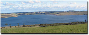 Lake Bullen Merri near Camperdown is a good example of a maar crater. It is surrounded by a prominent tuff ring. |
METAMORPHOSED: Material (usually sedimentary) that has been altered by heat and/or pressure (e.g. siltstone to schist, limestone to marble.
MESOZOIC: Geological time period that groups a number of the middle epochs (i.e. Triassic to Cretaceous 250 - 65 million years ago) (Geological timechart).
MORPHOLOGY: Description of landform based on dimensions (i.e. shape and size).
NEOTECTONIC: Recent (Quaternary age) earth movements usually along fault lines.
ORDOVICIAN: The Ordovician period extended from about 500-510 million years ago until 420-440 million years ago. During the Ordovician period much of what is now Victoria was part of a deep marine basin and nearly all of Ordovician rocks in Victoria are of deep water sedimentary origin (sandstones, mudstones and shales). (Geological timechart).
OROGENY: The term given to periods of mountain building, folding and faulting.
PALAEOLACUSTRINE: Remnant lake formations.
PALAEOZOIC: Geological time period that groups a number of the older epochs (i.e. Cambrian to Permian 550 - 250 million years ago) (Geological timechart).
PALUDAL: Sediments derived from swampy conditions.
PARENT MATERIAL: Generally used in soil description to denote the material from which the soil is derived. Lithologically variable, depending on processes that are active at that site. Parent material could be a rock type or in situ weathered material or unconsolidated material transported from elsewhere.
PEDOGENIC: Material formed by pedological processes (soil forming processes) exhibiting pedological features.
PENEPLAIN: A generally flat to slightly undulating plain that represents the mature phase of stream erosion - whereby streams have reached base level and then eroded the more resistant surrounding highland areas. Streams in such a landscape display extensive meandering and braiding.
PHYSIOGRAPHY:
PLEISTOCENE: The Pleistocene is an Epoch within the early Quaternary period, extending from about 1.6 million years ago to about 11 000 years ago. The end of the Pleistocene is marked by the last of the great Ice Ages.
PLIOCENE: An Epoch (within the Tertiary Period) in the geological time scale (1.6 - 5 million years ago). (Geological timechart).
PLIO-PLEISTOCENE: A period of time extending from the end of the Pliocene Epoch into the beginning of the Pleistocene Epoch. This time period is also extends from the end of the Tertiary Period into the start of the Quaternary Period, approximately 5 to 1 million years ago.
QUATERNARY: Geological time period from 1.6 - 1.8 mya to present. Much of the alluvial deposition is of this age, which in turn can be subdivided into different time periods (Geological timechart).
RADIOMETRICS: Radiometrics is a measure of the natural radiation in the earth’s surface, which can tell us about the distribution of certain soils and rocks. Geologists and geophysicists routinely use it as a geological mapping tool to tell them where certain rock types change. Radiometrics is also useful for the study of geomorphology and soils.
Radiometrics is also known as Gamma-Ray Spectrometry. A radiometric survey measures the spatial distribution of three radioactive elements (potassium-K, thorium-Th and uranium-U) in the top 30-45 cm of the earth’s crust. The abundances of K, Th and U are measured by detecting the gamma-rays produced during the natural radioactive decay of these elements.
For more information go to Radiometrics page.
REGOLITH: This is defined as weathered material between the soil and hard rock. Soil surveyors tend to restrict this term to the weathered C horizon of the soil, whereas geologists adhere to the depth of any unconsolidated material to hard rock (e.g. the depth of Tertiary and Quaternary unconsolidated sediments).
SHEPPARTON FORMATION: Quaternary alluvial sediments usually associated with the Riverine Plain in northern Victoria. These deposits consist of sands, gravels and clays that were deposited by a series of 'prior streams'. The Shepparton Formation usually consists of a number of buried soil profiles - associated with this prior streamactivity.
SILICEOUS: Material dominated by silica in a free form- predominantly in the form of quartz (SiO2). This material in its purist form is inert with no nutrient value and therefore limited in its overt use for agriculture.
SILURIAN: Geological time period within the Palaeozoic Era that spanned from approximately 436 million years ago to 405 million years before present (mybp). In the late Silurian, upright plants began to appear on land. During the Silurian much of southern Victoria was covered by shallow and deep seas (referred to as Melbourne Trough, Grampians Basin and Buchan Basin) and significant marine sediments were deposited (link to Geological timechart).
SINKHOLE: A landform caused by the erosion of subsurface material so that the ground surface collapses into a channel. It is a typical characteristic of tunnel-eroded landscapes.
SURFICIAL: Refers to surface sediments, generally unconsolidated.
TEPHRA: Lightweight unconsolidated volcanic material including ash.
TERTIARY: Geological time period from approximately 66 million years ago to 1.6 - 1.8 million years before present (mybp). A period of major dissection and deposition in Victoria, particularly closer to more recent times, producing large amounts of fan material flanking the uplands (Geological timechart).
TOMBOLO: A tombolo is a spit which joins an island to the mainland.
© State of Victoria (Agriculture Victoria) 1996 - .

This work, Victorian Resources Online, is licensed under a Creative Commons Attribution 4.0 licence. You are free to re-use the work under that licence, on the condition that you credit the State of Victoria (Agriculture Victoria) as author, indicate if changes were made and comply with the other licence terms.
The licence does not apply to ‘branding’ or some ‘images or photographs’ that may be owned by third parties. We ask you to seek prior approval to use images using the VRO feedback form. Access to higher quality images can also be provided on request.
This page was last updated on .