
WLRA144
|
| WLRA144 | 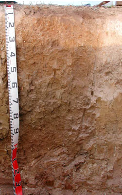 Vertic, Subnatric, Brown Sodosol | |
|
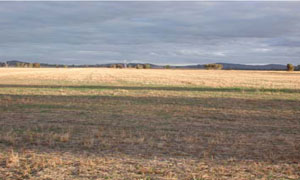
Location | Six Mile Creek, Joel South, western Victoria | |||
|
Landform | Level plain | |||
|
Geology | Quaternary recent alluvium: fluvial gravel, sand, silt | |||
|
Element | Plain | |||
|
Slope | 1% | |||
|
Aspect | West | |||
Horizon | Depth (cm) | Description | ||
A1 | 0–10 | Dark greyish brown (10YR4/2); sandy clay loam; weak very fine subangular blocky structure; rough ped-fabric; weak dry consistence; water repellent; pH 5.5; abrupt and smooth boundary to: | ||
A2 | 10–50 | Conspicuously bleached pale brown; common medium to coarse ferruginous nodules; clear and irregular boundary to: | ||
B1 | 10–30 | Strong brown (7.5YR4/6) light clay with very few fine faint pale brown mottles; weak fine subangular blocky structure; rough ped-fabric; firm dry consistence; pH 5.75; clear and irregular boundary to: | ||
B21 | 30/50–60 | Yellowish brown (10YR5/6) with few fine distinct orange and pale brown mottles; heavy clay; moderate fine angular blocky structure; smooth ped-fabric; strong moderately moist consistence; pH 7.0; gradual and smooth boundary to: | ||
B22 | 60–105 | Light olive brown (2.5Y5/4); heavy clay; weak coarse subangular blocky structure; rough ped-fabric; strong moderately moist consistence; few fine to coarse calcareous nodules and soft segregation patches, very few fine manganiferous fragments and nodules; pH 7.5; diffuse and smooth boundary to: | ||
B23 | 105–140+ | Brownish yellow (10YR6/6); medium clay; weak medium subangular blocky structure; rough ped-fabric; strong moderately moist consistence; few coarse to very coarse calcareous soft segregation patches; pH 8.75. | ||
| Management considerations | ||||
| ||||
Site WLRA144 | Sample depth cm | pH | EC dS/m | NaCl % | Ex Ca cmol-/kg | Ex Mg cmol-/kg | Ex K cmol-/kg | Ex Na cmol-/kg | Ex Al mg/kg | Ex acidity cmol-/kg | FC -30okPa | PWP -1500okPa | KS % | FS % | Z % | C % | |
Horizon | H2O | CaCl2 | |||||||||||||||
A1 | 0–10 | 5 | 4.4 | 0.12 | NA | 2.9 | 1.1 | 0.47 | 0.15 | 30 | NA | 27.4 | 8.9 | 9.4 | 50.4 | 6.5 | 31 |
A2 | 10–50 | NA | NA | NA | NA | NA | NA | NA | NA | NA | NA | NA | NA | NA | NA | NA | NA |
B1 | 10–30 | 5.3 | 4.6 | 0.1 | NA | 3.6 | 4.5 | 0.49 | 0.37 | 36 | NA | 34.9 | 16.5 | 4.2 | 36.8 | 8 | 46.5 |
B21 | 30/50–60 | 5.8 | 5 | 0.13 | NA | 5.4 | 9.7 | 0.64 | 1.1 | 16 | NA | 41.1 | 24.7 | 2.2 | 21.3 | 12 | 59 |
B22 | 60–105 | 7.8 | 6.9 | 0.14 | NA | 6.5 | 12 | 0.58 | 2 | NA | NA | 37 | 21 | 1.1 | 25.4 | 20 | 50.5 |
B23 | 105–140+ | 8.6 | 8.1 | 0.3 | <0.01 | 7.7 | 13 | 0.6 | 2.6 | NA | NA | 34.2 | 20.1 | 1.4 | 33.1 | 15.5 | 45.5 |
© State of Victoria (Agriculture Victoria) 1996 - .

This work, Victorian Resources Online, is licensed under a Creative Commons Attribution 4.0 licence. You are free to re-use the work under that licence, on the condition that you credit the State of Victoria (Agriculture Victoria) as author, indicate if changes were made and comply with the other licence terms.
The licence does not apply to ‘branding’ or some ‘images or photographs’ that may be owned by third parties. We ask you to seek prior approval to use images using the VRO feedback form. Access to higher quality images can also be provided on request.
This page was last updated on .