
6.1.5 Alluvium, terraces, floodplains, swamps and lunettes of the Volcanic Western Plains
|
Alluvium terraces and floodplains are associated with the lake and swamp systems within the volcanic terrain as well as drainage systems such as the Barwon, Yarrowee/Leigh and Woady Yaloak rivers. Lakes and swamps, both permanent and ephemeral dominate the volcanic plains north and west of Colac. Hydrologically, the lakes vary from hypersaline groundwater discharge lakes (e.g. Lake Beeac) to groundwater throughflow lakes with surface water input (e.g. Lake Murdeduke) (Coram 1996). In the Lough Calvert region (east of Beeac), climate changes during the Pleistocene and Holocene have resulted in a complex landscape, as lunettes and alluvium deposits trace the changes in lake levels. Alluvial terraces and lunettes have been formed and partially destroyed by oscillating lake levels (Edwards et al. 1996). Associated soil types include black and grey self-mulching and cracking clays, black (and some red) sodic texture contrast and dark loam soils. | 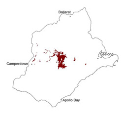 |
Soil-landform unit | Original unit ID | Unit description | Area (km2) |
20 | Alluvial plain and valley sides (and Woady Yaloak River) | 96 | |
4 | Lava plains and low rises (Derrinallum) | <0.5 | |
48 | Gently undulating lunettes (Lake Martin) | 2 | |
49 | Rolliing lunettes (e.g. Lake Gnarput) | 17 | |
119 | Ridge (Wiridgil) | 1 | |
123 | Gently undulating plains with low rises and lunettes, swamps and lakes (Beeac) | 97 | |
138 | Low ridges associated with lakes (e.g. Kariah) | 12 | |
162 | Gently undulating sandy rise (Foxhow) | 1 | |
226 | Undulating ridge-lunette (Lake Modwarre) | 3 | |
123 | Gently undulating plains with swamps, lakes and lunettes (Eurack) | 168 | |
123 | Gently undulating broad plains (Cressy) | 19 | |
46 | Enriched valley slopes and floor (Leigh River) | 73 | |
2 | Swamps and depressions (Derrinallum) | 136 |
© State of Victoria (Agriculture Victoria) 1996 - .

This work, Victorian Resources Online, is licensed under a Creative Commons Attribution 4.0 licence. You are free to re-use the work under that licence, on the condition that you credit the State of Victoria (Agriculture Victoria) as author, indicate if changes were made and comply with the other licence terms.
The licence does not apply to ‘branding’ or some ‘images or photographs’ that may be owned by third parties. We ask you to seek prior approval to use images using the VRO feedback form. Access to higher quality images can also be provided on request.
This page was last updated on .