
Soil/Landform Unit 154
Landform Unit Description
Page top
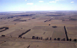 Looking north over the swamps, lunettes and plains of this unit |
0.14% of CMA region This unit consists of gently undulating plains, level plains swamps and drainage lines that occur near Cressy. Located within the volcanic Western Plains, the relief of this unit is subdued having a masked affect upon agricultural performance and land versatility. This unit has a number of components that are depositional landforms (such as the swamps, level and undulating plains). The unit is adjacent to lakes and basaltic (stony) rises and is found at the head of Lake Corangamite. The remnant vegetation includes less than 1% Plains Grassy Woodland. The soils are black strongly sodic texture contrast soils on the plains (coarse structure, hardsetting) with black and red cracking self-mulching soils on the lunettes, and black and grey cracking soils in the swamps. Land use is generally grazing, with the capability of the unit varying with component composition. The shallower soils and strongly structured soils on the lunettes provide more use throughout the year than the wetter flats. |  |
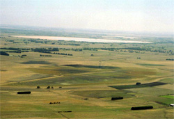 Lower plains and swamps line the southern boundary of this unit | 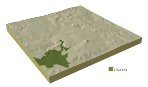 |
 | 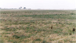 The broad plains are mainly used for grazing |
Component | 1 | 2 | 3 |
Proportion of soil-landform unit | 40% | 55% | 5% |
| CLIMATE Rainfall (mm) | Annual: 560 | ||
| Temperature (oC) | Minimum 8, Maximum 19 | ||
| Precipitation less than potential evapotranspiration | October-March | ||
| GEOLOGY Age and lithology | Recent clay, sand and gravel, basalt and minor coastal sand dunes | ||
| Geomorphology | |||
| LANDUSE | Uncleared: Nature conservation; water supply Cleared: Cropping; beef cattle and sheep grazing; dairy | ||
| TOPOGRAPHY Landscape | Gently undulating broad plains | ||
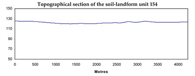
| Elevation range (m) | 119-140 | ||
| Local relief (m) | 2 | ||
| Drainage pattern | Centripetal | ||
| Drainage density (km/km2) | 1.3 | ||
| Landform | Plains | ||
| Landform element | Gently undulating plains | Level plains | Stream chennels |
| Slope and range (%) | 1 (0-5) | 1 (0-3) | 4 (1-8) |
| Slope shape | Linear | Linear | Linear |
| NATIVE VEGETATION Ecological Vegetation Class | Plains Grassy Woodland (1%) | ||
| SOIL Parent material | In situ basalt and associated colluvium | In situ basalt and associated colluvium | Alluvial clay, silt and sand |
| Description (Corangamite Soil Group) | Alkaline mottled black texture contrast soils, some not mottled (35) | Alkaline grey and black cracking clays (31) | |
| Soil type sites | |||
| Surface texture | Fine sandy clay loam | Fine sandy clay loam | Medium clay |
| Permeability | Low | Low | Very low |
| qDepth (m) | <2 | <2 | >2 |
| LAND CHARACTERISTICS, POTENTIAL AND LIMITATIONS | Texture contrast, possible surface waterlogging and compaction. Sodic subsoil, possibly the surface soil as well (structure decline). | Texture contrast, possible surface waterlogging and compaction. Sodic subsoils, possibly the surface soil as well (structure decline). | High seasonal watertable leads to soil compaction. High organic matter content, high clay content and expansive clays. May be better drained where lighter soil occurs. |
© State of Victoria (Agriculture Victoria) 1996 - .

This work, Victorian Resources Online, is licensed under a Creative Commons Attribution 4.0 licence. You are free to re-use the work under that licence, on the condition that you credit the State of Victoria (Agriculture Victoria) as author, indicate if changes were made and comply with the other licence terms.
The licence does not apply to ‘branding’ or some ‘images or photographs’ that may be owned by third parties. We ask you to seek prior approval to use images using the VRO feedback form. Access to higher quality images can also be provided on request.
This page was last updated on .