
Soil/Landform Unit 144
Landform Unit Description
Page top
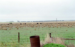 The level plains and low rise (is in the distance) are prone to waterlogging in wet seasons |
<0.01% of CMA region This unit comprises rises with associated swamps and depressions near Derrinallum. The rises have well developed regolith profiles and defined drainage, and form part of the dissected lava plains of the Western Plains. Soils on the rises include conspicuously bleached texture contrast soils with sporadically bleached soils on some rises, and grey cracking clays in the lower swamps and depressions. Red or brown texture contrast soils border these clay depressions and are the higher yielding areas. Very little surface stone occurs except occasionally on rise crests and upper slopes. Remnant vegetation on this unit includes Plains Grassland/Plains Grassy Woodland Mosaic. The land use is extensively grazing (mainly sheep) and minor cropping on the better yielding soils. Waterlogging, particularly on the lower slopes and depressions, is the major land management issue; combined with poor soil permeabilities this makes cropping these depressions extremely difficult. |  |
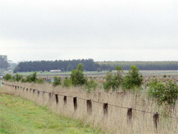 Plantations of blue gum is a new land use of these poorly drained level plains | 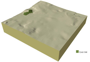 |
 |
Component | 1 | 2 | 3 | 4 |
Proportion of soil-landform unit | 3% | 50% | 40% | 7% |
| CLIMATE Rainfall (mm) | Annual: 610 | |||
| Temperature (oC) | Minimum 8, Maximum 19 | |||
| Precipitation less than potential evapotranspiration | October-April | |||
| GEOLOGY Age and lithology | Recent clay, sand and agravel and basalt | |||
| Geomorphology | ||||
| LANDUSE | Uncleared: Nature conservation Cleared: Sheep and beef cattle grazing; cropping (cereal) | |||
| TOPOGRAPHY Landscape | Lava plains and low rises | |||
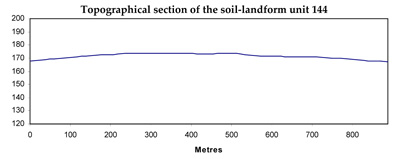
| Elevation range (m) | 168-189 | |||
| Local relief (m) | 2-10 | |||
| Drainage pattern | Centripetal | |||
| Drainage density (km/km2) | 0.4 | |||
| Landform | Low rises | Plains | Drainage depressions | |
| Landform element | Broad low crests and stony rises | Long gentle slopes | Broad plains | Swamps and depressions |
| Slope and range (%) | 3 (2-6) | 2 (1-5) | 1 (0-3) | 3 (0-5) |
| Slope shape | Convex | Linear | Straight | Concave |
| NATIVE VEGETATION Ecological Vegetation Class | Plains Grassland / Plains Grassy Woodland Mosaic (2.4%) | |||
| SOIL Parent material | Basalt | Basalt and colluvium | Basalt and colluvium | Clay sitl and sand and basalt |
| Description (Corangamite Soil Group) | Alkaline and neutral brown, grey or yellow texture contrast soils (36) | Alkaline and neutral brown, grey or yellow texture contrast soils and red texture contrast and brown gradational soils (36) | Alkaline and neutral brown, grey or yellow texture contrast soils (36) | Grey clays and red texture contrast and brown gradational soils (31) |
| Soil type sites | ||||
| Surface texture | Fine sandy clay loam | Fine sandy clay loam | Fine sandy clay loam | Light clay |
| Permeability | Moderate to low | Low | Low | Very low |
| Depth (m) | <1.5 | <2 | <2 | >2 |
| LAND CHARACTERISTICS, POTENTIAL AND LIMITATIONS | Texture contrast soil, moderate water holding capacity and moderate nutrient holding capacity in surface and subsurface soils, higher in deep subsoil. Low to very low permeability. Stony. Strongly sodic subsoil. Moderate site drainage. | Texture contrast soil, moderate water holding capacity and moderate nutrient holding capacity in surface and subsurface soils, higher in deep subsoil. Low to very low permeability. Some stone. Strongly sodic subsoil, possible surface soil associated with poor drainage. Moderate to slow site drainage. | Texture contrast soil, moderae water holding capacity and moderate nutrient holding capacity in surface and subsurface soils, higher in deep subsoil. Low to very low permeability. Some stone. Strongly sodic subsoil, possibly surface soil associated with poor drainage. Slow to very slow site drainage. | Uniform fine texture, expansive clays. High water holding capacity and nutrient holding capacity. Strongly sodic subsoil, possibly surface soil associated with poor drainage. Some friable self-mulching surfaces with high organic matter. Very slow site drainage. |
© State of Victoria (Agriculture Victoria) 1996 - .

This work, Victorian Resources Online, is licensed under a Creative Commons Attribution 4.0 licence. You are free to re-use the work under that licence, on the condition that you credit the State of Victoria (Agriculture Victoria) as author, indicate if changes were made and comply with the other licence terms.
The licence does not apply to ‘branding’ or some ‘images or photographs’ that may be owned by third parties. We ask you to seek prior approval to use images using the VRO feedback form. Access to higher quality images can also be provided on request.
This page was last updated on .