
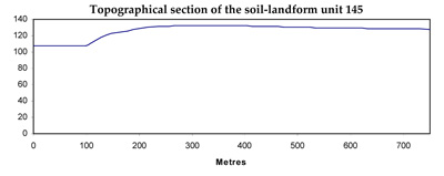
Soil/Landform Unit 145
Landform Unit Description
Page top
 Luenttes near Lake Martin |
0.02% of CMA region The lunettes that occur near Derrinallum and on the north-east shore of Lake Corangamite near Lake Martin represent a few of many lunettes across the dissected volcanics of the Western Plains. The gently undulating lunettes represent wind blow sands and clays from swamps and lakes indicating the major prevailing wind direction over time. Lake Corangamite and the swamp of Lake Martin provide waterbodies and wetlands for a variety of flora and fauna. No remnant vegetation occurs on these lunettes which have been cleared owing to their highly fertile deep black self-mulching clays on the slopes and crest. Cereal production is a prominent land use along with grazing. These expansive clay soils are strongly structured with moderate site drainage. Subsoils are likely to be calcareous and sodic with depth. |  |
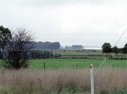 Dairy farming is a land use of these lunettes | 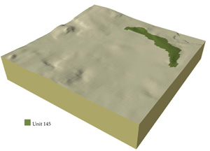 |
 |
Component | 1 | 2 |
Proportion of soil-landform unit | 40% | 60% |
| CLIMATE Rainfall (mm) | Annual: 590 | |
| Temperature (oC) | Minimum 8, Maximum 19 | |
| Precipitation less than potential evapotranspiration | October-March | |
| GEOLOGY Age and lithology | Recent clay, sand and gravel, coastal sand dunes and basalt | |
| Geomorphology | ||
| LANDUSE | Uncleared: Water supply catchment; nature conservations Cleared: Sheep and cattle grazing; cropping | |
| TOPOGRAPHY Landscape | Gently undulating lunettes | |
| Elevation range (m) | 118-170 | |
| Local relief (m) | 20 | |
| Drainage pattern | Dendritic | |
| Drainage density (km/km2) | 0.9 | |
| Landform | Lunette | |
| Landform element | Crests and upper slopes | Long gentle lower slopes |
| Slope and range (%) | 3 (1-8) | 2 (1-5) |
| Slope shape | Convex | Straight |
| NATIVE VEGETATION Ecological Vegetation Class | Absent | |
| SOIL Parent material | Aeolian clay sit and sand | Aeolian clay silt and sand |
| Description (Corangamite Soil Group) | Black self-mulching clays (9) | Black self-mulching clays (9) |
| Soil type sites | ||
| Surface texture | Light clay | Light clay |
| Permeability | High | High to moderate |
| Depth (m) | >2 | >2 |
| LAND CHARACTERISTICS, POTENTIAL AND LIMITATIONS | Uniform expansive clay. Firable, self-mulching upper soil. Sticky when wet. Strong fine structure. Alkaline, sodic and calcareous at depth. Moderate rapid site drainage. | Uniform expansive clay. Friable, self-mulching upper soil. Stocky when wet. Strong fine structure. Alkaline, sodic and calcareous at depth. Moderate site drainage. |
© State of Victoria (Agriculture Victoria) 1996 - .

This work, Victorian Resources Online, is licensed under a Creative Commons Attribution 4.0 licence. You are free to re-use the work under that licence, on the condition that you credit the State of Victoria (Agriculture Victoria) as author, indicate if changes were made and comply with the other licence terms.
The licence does not apply to ‘branding’ or some ‘images or photographs’ that may be owned by third parties. We ask you to seek prior approval to use images using the VRO feedback form. Access to higher quality images can also be provided on request.
This page was last updated on .