
Soil/Landform Unit 156
Landform Unit Description
Page top
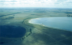 Swamps and waterbodies are prominent along the western boundary of the catchment. Many of these swamps in recent season have been dry and productive. |
1.02% of CMA region Across the dissected basalt plains of the Western Plains are numerous swamps and closed depressions that host a wide variety of flora and fauna. These swamps have been derived on Quaternary basalt, alluvial clay, sand and gravels and tend to be associated within two regions of the Western Plains. The reasoning for this is not entirely understood, but it would appear there is a high correlation of swamps with certain basalt flows. Most of the land has been cleared where these swamps were, or have been developed with drainage to remove excess surface water. Remnant vegetation classes on these plains include plains Sedgy Wetland, Stony Rises Herb-rich Woodland and Aquatic Herbland / Plains Sedgy Wetland Mosaic. Land use is mainly restricted to grazing owing to the waterlogged state of soils in most years, however cropping is quite productive when annual rainfall is below average. Soils include the grey cracking clays on the lava plains and black cracking clays associated with swamps and depressions of the stoney rises. While waterlogging is the major limitation, soil compaction may also be a limitation for production without adequately controlled traffic. | 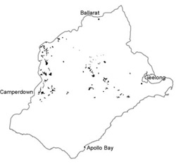 |
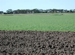 The cracking clays provide valuable soil moisture and nutrients that have resulted in good harvests over the last few seasons. | 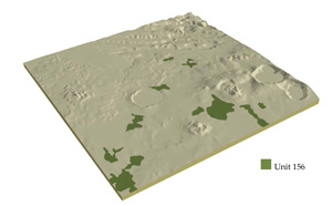 |
 | 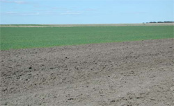 These soils are prone to compaction and waterlogging if managed poorly |
Component | 1 | 2 | 3 |
Proportion of soil-landform unit | 30% | 40% | 30% |
| CLIMATE Rainfall (mm) | Annual: 640 | ||
| Temperature (oC) | Minimum 8, Maximum 19 | ||
| Precipitation less than potential evapotranspiration | October-March | ||
| GEOLOGY Age and lithology | Quaternary basalt, clay, sand and gravel; minor Neogene marine sand | ||
| Geomorphology | |||
| LANDUSE | Uncleared: Nature conservation; water supply Cleared: Cropping (cereal); sheep and beef cattle grazing | ||
| TOPOGRAPHY Landscape | Swamps and depressions | ||
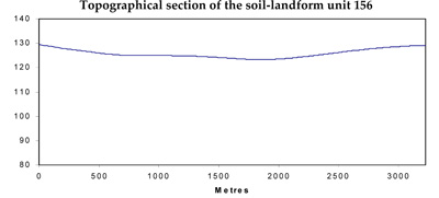
| Elevation range (m) | 66-302 | ||
| Local relief (m) | 0-10 | ||
| Drainage pattern | Deranged | ||
| Drainage density (km/km2) | 2.3 | ||
| Landform | Alluvial plain | ||
| Landform element | Depressions | Swamp | Undulating plain |
| Slope and range (%) | 1 (0-2) | 1 (0-2) | 2 (1-4) |
| Slope shape | Straight | Straight | Convex |
| NATIVE VEGETATION Ecological Vegetation Class | Plains Sedgy Wetland (0.7%), Stony Rises Herb-rich Woodland (0.5%), Aquatic Herbland / Plains Sedgy Wetland Mosaic (0.3%) | ||
| SOIL Parent material | Basalt derived alluvium; clay, silt and sand | Basalt derived alluvium; clay, silt and sand | Basalt derived alluvium; clay, silt and sand |
| Description (Corangamite Soil Group) | Grey and black clays (31) | Grey and black clays (31) | Grey and black clays (31) |
| Soil type sites | |||
| Surface texture | Light clay | Light clay | Light clay |
| Permeability | Low | Very low | Low |
| Depth (m) | >2 | >2 | >2 |
| LAND CHARACTERISTICS, POTENTIAL AND LIMITATIONS | Uniform expansive clays; high to very high water holding capacity and nutrient holding capacity depending on depth. Sodic subsoils, surface soils may be self-mulching. Low site drainage. Susceptibility to waterlogging. | Uniform expansive clays; high to very high water holding capacity and nutrient holding capacity depending on depth. Sodic subsoils, surface soils may be self-mulching. Low site drainage. Susceptibility to waterlogging. | Uniform expansive clays; high to very high water holding capacity and nutrient holding capacity depending on depth. Sodic subsoils, surface soils may be self-mulching. Low site drainage. Susceptibility to waterlogging. |
© State of Victoria (Agriculture Victoria) 1996 - .

This work, Victorian Resources Online, is licensed under a Creative Commons Attribution 4.0 licence. You are free to re-use the work under that licence, on the condition that you credit the State of Victoria (Agriculture Victoria) as author, indicate if changes were made and comply with the other licence terms.
The licence does not apply to ‘branding’ or some ‘images or photographs’ that may be owned by third parties. We ask you to seek prior approval to use images using the VRO feedback form. Access to higher quality images can also be provided on request.
This page was last updated on .