
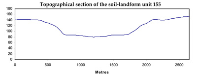
Soil/Landform Unit 155
Landform Unit Description
Page top
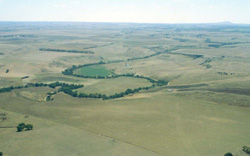 View north of the entrenched valley and valley floors near Shelford |
0.55% of CMA region Dissection of the lava plains in the Western Plains of the Corangamite region has lead to development of a steeply dissected entrenched valley with a broad alluvial floor. This unique landscape includes the ox-bows of the Leigh River and the Barwon River north of Winchelsea. The entrenched valley and valley floor includes Floodplain Riparian Woodland and Streambank Shrubland as the major vegetation classes. The unit has a wide variety of geologies including Ordovician sediments; Neogene marl, limestone, sands and gravels; Quaternary volcanics and alluvium. This dissection has produced steeply dissected terrain highlighting a wide diversity of geologies in these steep slopes and scarps. The unit consists of black cracking clays on the alluvial plains and in the ox-bows. Active channel aggradation or over-bank stream flow has lead to the development of deep, very poorly structured silty loams. There are minor occurrences of mottled brown texture contrast soils on the alluvial plains particularly in the Inverleigh area. Land use includes water supply, grazing, cropping, horticulture and residential development near Winchelsea. Erosion hazards are high at scarps and steep slopes, which have a high susceptibility to soil loss. Landslips and rock fall are also hazards of this steep terrain. Areas with shallow stony gradational soils are susceptible to leaching of nutrients, and compaction is a problem on the alluvial plains. |  |
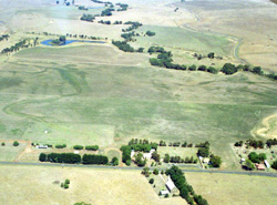 Valley floor with billabongs south of Shelford | 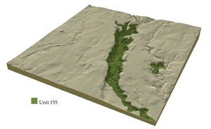 |
 | 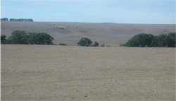 Valley flor and steep valley side slopes |
Component | 1 | 2 | 3 | 4 | 5 | 6 | 7 | 8 |
Proportion of soil-landform unit | 7% | 10% | 22% | 6% | 25% | 20% | 3% | 7% |
| CLIMATE Rainfall (mm) | Annual: 570 | |||||||
| Temperature (oC) | Minimum 9, Maximum 19 | |||||||
| Precipitation less than potential evapotranspiration | October-April | |||||||
| GEOLOGY Age and lithology | Quaternary basalt | Neogene unconsolidated sediements - gravel, sand and clay | Various Neogene strata, unconsolidated sediments, limetstone, etc. | Ordovician slates and sandstone interbedded | Quaternary alluvium | |||
| Geomorphology | ||||||||
| LANDUSE | Uncleared: Nature conservation; water supply Cleared: Sheep and beef cattle grazing; water supply; cropping; horiticulture | |||||||
| TOPOGRAPHY Landscape | Entrenched valley slopes and floors | |||||||
| Elevation range (m) | 27-192 | |||||||
| Local relief (m) | 45 | |||||||
| Drainage pattern | Dendritic | |||||||
| Drainage density (km/km2) | 4.7 | |||||||
| Landform | Steep river valley sides | Terrace 2 | Terrace 1 | Depressions and billabongs in Terrace 1 | River channel bed, banks and levees | |||
| Landform element | Stony upper slope | Upper slope or crest | Mid slope | Lower slope | Higher terraces | Lower terraces | Low-lying wet areas | |
| Slope and range (%) | 32 (20-60) | 20 (10-50) | 20 (10-50) | 20 (10-50) | 2 (0-3) | 1 (0-2) | 0 (0-2) | 1 (0-2) |
| Slope shape | Convex to straight | Convex | Straight to concave | Straight to concave | Straight | Straight | Concave | Concave |
| NATIVE VEGETATION Ecological Vegetation Class | Floodplain Riparian Woodland (3%), Streambank Shrubland (2.4%) | |||||||
| Dominant species | E. leucoxylon, E. camaldulensis | E. leucoxylon, E. camaldulensis | E. leucoxylon, E. melliodora, E. viminalis | E. leucoxylong, E. camaldulensis | E. camaldulensis | E. camaldulensis | E. camaldulensis | |
| SOIL Parent material | In situ weathered basalt | In situ unconsolidated sediments with some areas of colluvial basalt | In situ unconsolidated sediments and limestone, with colluvium from higher land. some quartzite outcrops. | In situ slates and sandstone with colluvium. | Unconsolidated gravel, sand, silt and clay | Unconsolidated gravel, sand, silt and clay | Unconsolidated gravel, sand, silt and clay | Unconsolidated gravel, sand, silt and clay |
| Description (Corangamite Soil Group) | Stony shallow brown clay soils (39) | Mottled brown, grey or yellow gradational or texture contrast soils (26) | Red texture contrast soils, some dark texture contrast soils (33) | Dark loams (34) | Dark clay soils (31) | Channel - variable levell - uniform fine sands (34) | ||
| Soil type sites | ||||||||
| Surface texture | Clay loam | Clay to clay loam | Mostly clay with some sandy areas | Fine sandy clay oam | Loamy sand and sandy loam | Loam to clay loam | Clay loam to clay | Variable |
| Permeability | Moderate | Moderate to low | Moderate | Moderate to low | Moderate | High | Low | Moderate |
| Depth (m) | 0.1-0.5 | 0.5-1.2 | 0.3-2.0 | 0.3-1.0 | 0.5-1.0 | 0.2-0.8 | 0.8-1.5 | >2 |
| LAND CHARACTERISTICS, POTENTIAL AND LIMITATIONS | Steep slopes are subject to undercutting, slumping and falling rocks. | Deep black clayey soils on moderate to steep slopes are subject to overland flow, moderate slip hazard and rilling on exposed soil. | Deep black clayey soils on moderate to steep slopes are subject to overland flow, moderate slip hazard and rilling on exposed soil. | Dispersible clay soils on moderate to very steep slopes are subject to overland flows, moderate sheet and rill erosion. | Overland flow and minor sheet erosion are features on exposed soils of the higher terraces. | Low situation affected by flooding and siltation from river, overland flow and periodic waterlogging. | Low situation affected by flodding and siltation from river, overland flow and periodic waterlogging. | Low situation affected by flooding and siltration from river, overland flow, periodic waterlogging and streambank erosion. |
© State of Victoria (Agriculture Victoria) 1996 - .

This work, Victorian Resources Online, is licensed under a Creative Commons Attribution 4.0 licence. You are free to re-use the work under that licence, on the condition that you credit the State of Victoria (Agriculture Victoria) as author, indicate if changes were made and comply with the other licence terms.
The licence does not apply to ‘branding’ or some ‘images or photographs’ that may be owned by third parties. We ask you to seek prior approval to use images using the VRO feedback form. Access to higher quality images can also be provided on request.
This page was last updated on .