
Soil/Landform Unit 147
Landform Unit Description
Page top
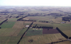 Looking over the Wiridgil plains north-east of Camperdown. The low undulating ridge is masked partially by cloud shadow in a lower plain of this landscape |
<0.01% of CMA region This unit is an undulating extremely low ridge located east of Camperdown in an area of lower plains bordering the volcanic eruption complex around Camperdown. This unit within the Western Plains is a small single unit and consists of low relief and moderate site drainage, falling within a wetter part of the volcanic plains. Arguably this unit may have been derived from some aeolian influence. The soil is a cracking clay with friable self-mulching surface soils, and is mainly used for grazing. Soils have a high nutrient holding capacity, but are heavy natured and therefore dependent upon seasonal conditions for optimal use. Soil compaction on lower slopes should be a consideration particularly in wet seasons. | 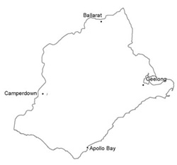 |
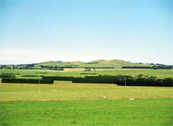 View towards Wiridgil Hill. Between this volcanic hill and the Princes Highway lies the undulating lunette of this unit | 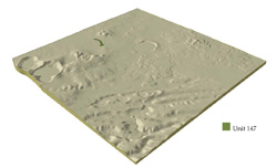 |
 | 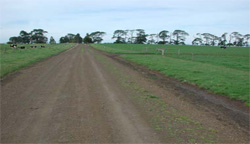 Slopes of the lunette are used for dairy grazing |
Component | 1 | 2 |
Proportion of soil-landform unit | 25% | 75% |
| CLIMATE Rainfall (mm) | Annual: 740 | |
| Temperature (oC) | Minimum 8, Maximum 19 | |
| Precipitation less than potential evapotranspiration | October-March | |
| GEOLOGY Age and lithology | ||
| Geomorphology | ||
| LANDUSE | Uncleared: Nature conservation Cleared: Cropping; beef cattle and sheep grazing; dairy | |
| TOPOGRAPHY Landscape | Ridge | |
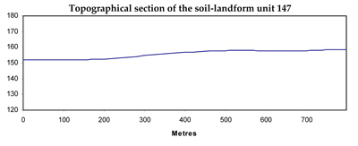
| Elevation range (m) | 151-158 | |
| Local relief (m) | 7 | |
| Drainage pattern | Radial | |
| Drainage density (km/km2) | 3.1 | |
| Landform | Low ridge (lunette) | |
| Landform element | Narrow crest | Slopes |
| Slope and range (%) | 5 (1-10) | 5 (2-9) |
| Slope shape | Convex | Convex |
| NATIVE VEGETATION Ecological Vegetation Class | Grassy Woodland (7.1%), Swamp Scrub (1.2%) | |
| SOIL Parent material | Aeolian deposits; clays and silts | Aeolian deposits and alluvium; clays and silts |
| Description (Corangamite Soil Group) | Neutral and alkaline black cracking clays (9) | Neutral and alkaline black cracking clays (9) |
| Soil type sites | ||
| Surface texture | Light medium clay | Medium clay |
| Permeability | Moderate | Low to moderate |
| Depth (m) | >2 | >2 |
| LAND CHARACTERISTICS, POTENTIAL AND LIMITATIONS | Strongly structured but expansive clay soils, with moderate to rapid site drainage. High nutrient capacity, calcareous and sodic, particularly at depth. | Strongly structured but expansive clay soils, with moderate to rapid site drainage. High nutrient capacity, calcareous and sodic, particularly at depth. |
© State of Victoria (Agriculture Victoria) 1996 - .

This work, Victorian Resources Online, is licensed under a Creative Commons Attribution 4.0 licence. You are free to re-use the work under that licence, on the condition that you credit the State of Victoria (Agriculture Victoria) as author, indicate if changes were made and comply with the other licence terms.
The licence does not apply to ‘branding’ or some ‘images or photographs’ that may be owned by third parties. We ask you to seek prior approval to use images using the VRO feedback form. Access to higher quality images can also be provided on request.
This page was last updated on .