
Soil/Landform Unit 146
Landform Unit Description
Page top
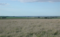 The broad rolling lunette crest of Lake Murdeduke. This lunette supports a wide range of land uses |
0.13% of CMA region Prominent lakes of the Western Plains including Lake Corangamite, Lake Gnarpurt, Lake Rosine (near Cressy) and Lake Murdeduke (near Winchelsea) have developed large and significant rolling lunettes on their shore margins. These lunettes represent the deposition sites of wind blow sands and clays from swamps and lakes indicating the major prevailing wind direction over time. While the lakes provide habitats for many forms of flora and fauna, the lunettes have a vegetation community of Grassy Woodland. With much of the land cleared for grazing and cropping, the soils are often further exposed to winds causing wind erosion. Sheet and rill erosion can also be an issue where these light soils are exposed. The soils are dominantly highly fertile deep black self-mulching clays on the slopes and crest. Hard and soft calcareous segregations with higher levels of sodium are a common feature of their deep subsoil. |  |
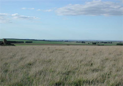 Although not easily visible, in the distance a piggery exists on the south-eastern slopes of the lunette at Lake Murdeduke | 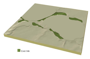 |
 |
Component | 1 | 2 | 3 |
Proportion of soil-landform unit | 20% | 35% | 45% |
| CLIMATE Rainfall (mm) | Annual: 600 | ||
| Temperature (oC) | Minimum 9, Maximum 19 | ||
| Precipitation less than potential evapotranspiration | October-March | ||
| GEOLOGY Age and lithology | Quaternary coastal sand dune and basalt | ||
| Geomorphology | |||
| LANDUSE | Uncleared: Water supply / catchment; nature conservation Cleared: Sheep and cattle grazing; cropping | ||
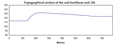
| TOPOGRAPHY Landscape | Rolling lunettes | ||
| Elevation range (m) | 86-147 | ||
| Local relief (m) | 18 | ||
| Drainage pattern | Dendritic | ||
| Drainage density (km/km2) | 1.2 | ||
| Landform | Lunettes | ||
| Landform element | Broad low crest | Gentle mid slopes | Long gentle lower slopes |
| Slope and range (%) | 3 (1-6) | 2 (1-5) | 2 (1-3) |
| Slope shape | Convex | Straight | Straight |
| NATIVE VEGETATION Ecological Vegetation Class | Grassy Woodland (2.4%) | ||
| SOIL Parent material | Aeolian clay silt and sand | Aeolian clay silt and sand | Aeolian clay silt and sand |
| Description (Corangamite Soil Group) | Black self-mulching cracking clays (9) | Black self-mulching cracking clays (9) | Black self-mulching cracking clays (9) |
| Soil type sites | |||
| Surface texture | Light clay | Light clay | Light clay |
| Permeability | High | High | Moderate |
| Depth (m) | >2 | >2 | >2 |
| LAND CHARACTERISTICS, POTENTIAL AND LIMITATIONS | Uniform expansive clay. Firable, self-mulching upper soil. Sticky when wet. Strong fine structure. Alkaline, sodic and calcareous at depth. Moderately rapid site drainage. | Uniform expansive clay. Friable, self-mulching upper soil. Sticky when wet. Strong fine structure. Alkaline, sodic and calcareous at depth. Moderate site drainage. | Uniform expansive clay. Friable, self-mulching upper soil. Sticky when wet. Strong fine structure. Alkaline, sodic and calcareous at depth. Moderate site drainage. |
© State of Victoria (Agriculture Victoria) 1996 - .

This work, Victorian Resources Online, is licensed under a Creative Commons Attribution 4.0 licence. You are free to re-use the work under that licence, on the condition that you credit the State of Victoria (Agriculture Victoria) as author, indicate if changes were made and comply with the other licence terms.
The licence does not apply to ‘branding’ or some ‘images or photographs’ that may be owned by third parties. We ask you to seek prior approval to use images using the VRO feedback form. Access to higher quality images can also be provided on request.
This page was last updated on .