
3.3.2 Dissected rolling low hills of the Southern Uplands
|
South of Colac, low hills formed on the uplifted Palaeogene sediments south of the Colac Monocline constitute the foothills to the north of the Otway Ranges. The gently undulating hills are generally rounded, although some have broader planar crests, and may be described as undulating plains. The dendritic drainage network forms tributaries to the Barwon and Gellibrand rivers. Further east (south of the Barrabool Hills) the rolling hills are less well defined and are transitional to the sedimentary plains (geomorphic unit 6.2). | 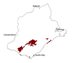 |
Soil-landform unit | Original unit ID | Unit description | Area (km2) |
| - | Low hills-scarp (e.g. Wallington) | 7 | |
| Barongarook L.S. | Gently undualting to rolling plain | 15 | |
| Ferguson Hill L.S. | Undulating hills and ridges | 69 | |
| Kennedys Creek L.S. | Undulating plain | 104 | |
| Yeodene L.S. | Rolling plain (western Barwon River catchment and northern Gellibrand River catchment) | 54 | |
| Anglesea L.S. | Coastal moderately dissected hills | 45 | |
| Kawarren L.S. | Roling hills (upper northern Gellibrand River catchment) | 51 | |
| Rivernook L.S. | Deeply dissected uplifted plains with coastal cliffs | 18 | |
| 147 | Undulating plain (northern Gellibrand River catchment) | 104 | |
| Barongarook L.S. | Gently undulating to rolling plain (western Barwon River catchment) | 77 |
© State of Victoria (Agriculture Victoria) 1996 - .

This work, Victorian Resources Online, is licensed under a Creative Commons Attribution 4.0 licence. You are free to re-use the work under that licence, on the condition that you credit the State of Victoria (Agriculture Victoria) as author, indicate if changes were made and comply with the other licence terms.
The licence does not apply to ‘branding’ or some ‘images or photographs’ that may be owned by third parties. We ask you to seek prior approval to use images using the VRO feedback form. Access to higher quality images can also be provided on request.
This page was last updated on .