
Soil/Landform Unit 91
Landform Unit Description
Page top
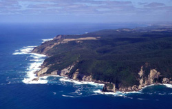 Rugged coast cliffs and undulating plain near Point Reginald |
0.13% of CMA region Paleogene sediments outcrop along the coast at Moonlight Head, Rotten Point and Apollo Bay. The terrain is a deeply dissected plain fronted by steep coastal cliffs. The rainfall is high (850–1000 mm). The soils vary, ranging from old profiles with evidence of ferruginisation to young soils with little horizon development. The native vegetation appears to be more dependent on exposure to salt- and sand-laden coastal winds than on the soil type. Casuarina luehmannii at Rotten Point is an unusual member of the vegetative community, but most species are well adapted to the harsh environment. Clearing is confined to an area near Apollo Bay used for grazing. The area has high landscape and nature conservation values, but disused sand and gravel extraction pits at Moonlight Head and Rotten Point detract from these attributes. Once the vegetation is disturbed, reestablishment is slow and difficult, and sheet, rill and gully erosion are likely to occur. | 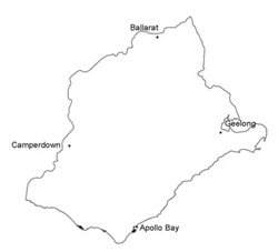 |
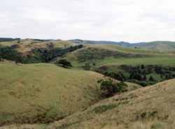 Dissected low hills and hills south of Marengo | 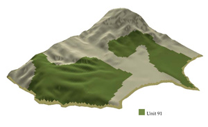 |
 | 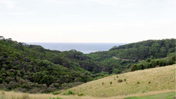 Heathy scrubland leading to costal cliffs at Storm Point |
Component | 1 | 2 | 3 | 4 | 5 |
Proportion of soil-landform unit | 10% | 20% | 30% | 30% | 10% |
| CLIMATE Rainfall (mm) | Annual: 850-1000, lowest January (40), highest July (110) | ||||
| Temperature (oC) | Annual: 14, lowest July (10), highest February (18) | ||||
| Precipitation less than potential evapotranspiration | Temperature: No month less than 10oC (av.) Precipitation: Exceeds potential evapotranspiration all months | ||||
| GEOLOGY Age and lithology | Cretaceous fluvio-volcanic sandstone and mudstone | Paleogene marine sand and clay; minor Neogene fluvial sand | Recent calcareous clay and sand | ||
| Geomorphology | |||||
| LANDUSE | Uncleared areas: Nature conservation; landscape conservation; sand and gravel extraction; forest grazing Minor cleared areas: Residential; dairy farming; beef cattle grazing often on unimproved pastures | ||||
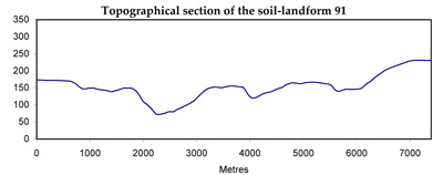
| TOPOGRAPHY Landscape | Deeply dissected uplifted plains with coastal cliffs | ||||
| Elevation range (m) | 0-150 | ||||
| Local relief (m) | 70 | ||||
| Drainage pattern | Dendritic | ||||
| Drainage density (km/km2) | 2.3 | ||||
| Landform | Cliffs | Deeply dissected plains | Dune | ||
| Landform element | - | Lower slope | Dissected slope | Upper slope and crest | - |
| Slope and range (%) | 70 | 7 (4-12) | 14 (2-36) | 5 (1-14) | 14 (2-36) |
| Slope shape | Concave | Linear | Convex | Convex | Convex |
| NATIVE VEGETATION Ecological Vegetation Class | Open heath to tall shrubland | Open scrub | Open scrub | Low woodland | Open scrub |
| Dominant species | Casuarina stricta, Cassinia longifolia, HHelichrysum paralium, Casuarina luehmanii, Calocephalus brownii | E. baxteri, E. nitida, Leptospermum juniperinum, E. ovata, E. obliqua | E. baxteri, E. nitida, Leptospermum juniperinum, Casuarina luehmanii, Cassinia longifolia, E. ovata, E. obliqua | E. baxteri, E. ovata, E. nitida | Helichrysum paralium, Leptospermum juniperinum, Cassinia longifolia, Acacia verticillata |
| SOIL Parent material | Beach sand, some cliff detritus | Clay, silt and sand | Sand | Clay, silt and sand | Calcareous sand |
| Description (Corangamite Soil Group) | Stony brown gradational soils (7) | Grey sand soils with hardpans (29) | Brown calcareous sand soils (12) | ||
| Soil type sites | OTR732 | OTR750 | OTR782 | ||
| Surface texture | Loamy sand | Sandy loam | Loamy sand | Sandy loam | Loamy sand |
| Permeability | Very high | Low | Low | Moderate | Very high |
| Depth (m) | 0.1 | >2 | >2 | >2 | >2 |
| LAND CHARACTERISTICS, POTENTIAL AND LIMITATIONS | Native vegetation is sensitive to salt pruning and disturbance. Dispersible soils of low water holding capacity on steep slopes with underlying rock are prone to sheet erosion. Wave undercutting and saturation of soils lead to landslides. Weakly structured sand soils are prone to wind erosion. | Highly dispersible soils are prone to gully and tunnel erosion. Weakly sructured surfaces over slowly permeable subsoils are prone to sheet and rill erosion. | Weakly structured surfaces overlying hardpans on steeper slopes are prone to sheet and rill erosion. Very low inherent fertility and leaching of permeable surfaces lead to nutrient decline. | Weakly structured surfaces and impeding ironstone layers lead to sheet erosion on steeper slopes. Low inherent fertility, phosphorus fixation and leaching of permeable surface horizons lead to nutrient decline. | Weakly structure sands subject to strong coastal winds are prone to wind erosion. Low inherent fertility, high alkalinity and rapid leaching lead to nutrient decline. |
© State of Victoria (Agriculture Victoria) 1996 - .

This work, Victorian Resources Online, is licensed under a Creative Commons Attribution 4.0 licence. You are free to re-use the work under that licence, on the condition that you credit the State of Victoria (Agriculture Victoria) as author, indicate if changes were made and comply with the other licence terms.
The licence does not apply to ‘branding’ or some ‘images or photographs’ that may be owned by third parties. We ask you to seek prior approval to use images using the VRO feedback form. Access to higher quality images can also be provided on request.
This page was last updated on .