
Soil/Landform Unit 88
Landform Unit Description
Page top
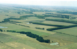 Rolling plains near Yeodene |
0.40% of CMA region West of Yeodene, a rolling and irregular landscape forms part of a broad ridge extending from the foothills of the Otway Ranges towards Colac. Paleogene sand outcrops on most parts of the landscape, often forming a veneer over exposures of Paleogene silt and clay. The soils have loamy sand or sandy loam surface textures and are prone to nutrient and moisture deficiencies. Hardpans between the sand veneers and clay horizons may result in perched watertables, although only small areas have such poor site drainage that frequent waterlogging occurs. Sand and gravel have been extensively mined in some areas, and pine plantations have been established near Yeodene. However, most of the area remains in a fairly natural state and constitutes a significant area of natural vegetation close to Colac. Its potential for recreation is at present not fully utilised. Only minor areas have been cleared for agriculture, but the establishment of improved pastures is difficult. |  |
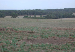 The rolling plains have broad crests that support gazing and cropping as the major land uses | 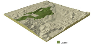 |
 | 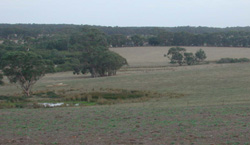 Slopes graduate into broad depressions and drainage lines |
Component | 1 | 2 | 3 | 4 | 5 |
Proportion of soil-landform unit | 35% | 25% | 5% | 30% | 5% |
| CLIMATE Rainfall (mm) | Annual: 750-850, lowest January (40), highest August (100) | ||||
| Temperature (oC) | Annual: 13, lowest July (8), highest February (19) | ||||
| Seasonal growth limitations | Temperature: less than 10oC (av.) June-August Precipitation: less than potential evapotranspiration late October-early April | ||||
| GEOLOGY Age and lithology | Paleogene marine mudstone, sandstone, silty clay and Cretaceous fluvio-volcanic mudstone, sandstone and conglomerate, Recent sand veneer | ||||
| Geomorphology | |||||
| LANDUSE | Uncleared areas: Hardwood forestry for posts, poles and fuel; sand and gravel extraction; forest grazing; water supply; passive and active recreation; softwood forestry Minor cleared areas: Sheep and beef cattle grazing; dairy farmins | ||||
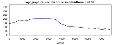
| TOPOGRAPHY Landscape | Rolling plain in the western parts of the Barwon catchment and northern parts of the Gellibrand catchment | ||||
| Elevation range (m) | 120-260 | ||||
| Local relief (m) | 40 | ||||
| Drainage pattern | Dendritic | ||||
| Drainage density (km/km2) | 1.3 | ||||
| Landform | Plains | ||||
| Landform element | Crest and slope | Slope | Broad slightly depressed area | Crest and slope | Drainage line |
| Slope and range (%) | 9 (1-15) | 15 (5-20) | 2 (0-5) | 8 (1-15) | 3 (1-5) |
| Slope shape | Convex | Irregular | Concave | Linear | Concave |
| NATIVE VEGETATION Ecological Vegetation Class | Woodland | Woodland | Low woodland | Open forest | Low woodland |
| Dominant species | E. viminalis, E. obliqua, E. radiata | E. radiata, E. ovata, E. viminalis occasionally E. obliqua | E. nitida, E. radiata, occasionally E. viminalis | E. obliqua, E. radiata | E. ovata, Acacia melanoxylon, Leptospermum juniperinum, Melaleuca squarrosa |
| SOIL Parent material | Quartz sand | Silt and clay with sand veneer | Silt and clay with sand veneer | Clay, sitl and sand | Colluvial and alluvial sand, silt and clay, plant remains |
| Description (Corangamite Soil Group) | Grey sand soils (29) | Grey sand soils, weakly structured clay underlay (11) | Grey sand soils, weakly structured clay underlay (11) | Black sand soils (29) | |
| Soil type sites | OTR742 | - | - | OTR497, OTR741 | OTR609, OTR739 |
| Surface texture | Loamy sand | Loamy sand | Loamy sand | Sandy loam | Silty loam |
| Permeability | Very high | Low | Low | High | Moderate |
| Depth (m) | >2 | >2 | 0.6 | >2 | >2 |
| LAND CHARACTERISTICS, POTENTIAL AND LIMITATIONS | Very low inherent fertility and high permeability lead to nutrient decline. | Low inherent fertility and leaching permeable surfaces lead to nutrient decline. Weakly structured surfaces and low permeabilities lead to sheet erosion on steeper slopes. | Low permeability and poor site drainage lead to seasonal waterlogging and soil compaction. | Weakly structured surfaces on steeper slopes are prone to sheet erosion. | High watertables lead to waterlogging and soil compaction. Runoff from adjacent hills leads to siltation and flooding. |
© State of Victoria (Agriculture Victoria) 1996 - .

This work, Victorian Resources Online, is licensed under a Creative Commons Attribution 4.0 licence. You are free to re-use the work under that licence, on the condition that you credit the State of Victoria (Agriculture Victoria) as author, indicate if changes were made and comply with the other licence terms.
The licence does not apply to ‘branding’ or some ‘images or photographs’ that may be owned by third parties. We ask you to seek prior approval to use images using the VRO feedback form. Access to higher quality images can also be provided on request.
This page was last updated on .