
Kawarren Land System
Download the pdf version of this document: Kawarren Land System (PDF - 536 KB)
To view the information, PDF requires the use of a PDF reader. This can be installed for free from the Adobe website (external link).
| Rolling hills with occasional steep slopes and broad drainage lines are found in the vicinity of Kawarren. The landscape has several components, including some areas of red stony brown gradational soils developed on outcrops of basalt. However, old soils on deeply weathered Tertiary clay and sand tend to dominate the landscape. Other land systems with similar soils and parent material are found to the east and west of this land system. However, the Kawarren land system is a rolling landscape whereas the others are gently undulating to flat. The Barongarook land system to the east has a slightly lower rainfall and Eucalyptus baxteri has not been observed in this area. Clearing has been common and the main land uses are dairy farming and grazing of beef cattle and sheep. Some forested areas, such as the old Beech Forest railway escarpment, are popular for bushwalking. Pine establishment is common on private land. Sheet erosion and landslips have occurred on the steeper slopes. | 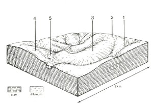 |
Most of the cleared areas are used for dairy farming. | 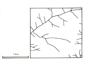 |
Area: 41 km2 | Component and its proportion of land system | ||||
1 15% | 2 10% | 3 60% | 4 10% | 5 5% | |
| CLIMATE Rainfall, mm | Annual: 850 – 1,100, lowest January (40), highest August (120) | ||||
Temperature, 0oC | Annual: 12, lowest July (8), highest February (18) | ||||
Temperature: less than 10oC (av.) June – September | |||||
Precipitation: less than potential evapotranspiration November - March | |||||
GEOLOGY Age, lithology | Paleocene unconsolidated clay, silt and sand | ||||
TOPOGRAPHY Landscape | Rolling hills in the northern upper reaches of the Gellibrand River catchment | ||||
Elevation, m | 75 - 210 | ||||
Local relief, m | 60 | ||||
Drainage pattern | Dendritic with some radial areas | ||||
Drainage density, km/km2 | 2.6 | ||||
| Land form | Hill | Valley floor | |||
| Land form element | Steep slope | Crest, upper slope | Crest, slope | Slope | - |
Slope (and range), % | 20 (10-45) | 12 (3-15) | 9 (1-15) | 13 (6-15) | 1 (0-2) |
Slope shape | Linear | Convex | Convex | Linear | Concave |
NATIVE VEGETATION Structure | Open forest | Woodland | Open forest | Open forest | Low woodland |
Dominant species | E. obliqua, E. radiata, E. viminalis | E. radiata, E. obliqua, E. nitida, E. ovata | E. obliqua, . radiata, E. viminalis; occasionally E. ovata | E. aromaphloia, E. obliqua, E. radiata, occasionally E. ovata | E. ovata, E. radiata, Melaleuca squarrosa |
SOIL Parent material | Clay, silt and sand | Colluvial sand on unconsolidated clay | Clay, silt and sand | Clay, silt and sand | Alluvial clay, sand and silt |
Description | Yellow gradational soils, weak structure | Grey sand soils, structured clay underlay | Mottled yellow and red gradational soils | Yellow-brown gradational soils, coarse structure | Grey gradational soils |
Surface texture | Sandy loam | Sandy loam | Fine sandy loam | Fine sandy loam | Fine sandy loam |
Permeability | High | Low | Moderate | Low | Very low |
Depth, m | >2 | >2 | >2 | >2 | >2 |
| LAND USE | Uncleared areas: Hardwood forestry for sawlogs, posts and poles; softwood plantations; nature conservation; passive recreation; water supply; forest grazing. Cleared areas: Beef cattle and sheep grazing; dairy farming; water supply | ||||
| SOIL DETERIORATION HAZARD Critical land features, processes, forms | Clay subsoils on steep slopes subject to periodic saturation are prone to landslips. Steep slopes are prone to sheet and rill erosion. | Low subsoil permeabilities leads to seasonal waterlogging. Low inherent fertility and permeable surface horizons lead to nutrient decline. | Low inherent fertility and phosphorus fixation lead to nutrient decline. | Dispersible clay subsoils of low permeability are prone to gully erosion. Clay subsoils on steeper slopes subject to periodic saturation are prone to landslips. | Low permeabilities and high water tables lead to seasonal waterlogging. High discharge rates along watercourses lead to some flooding and gully erosion. |
© State of Victoria (Agriculture Victoria) 1996 - .

This work, Victorian Resources Online, is licensed under a Creative Commons Attribution 4.0 licence. You are free to re-use the work under that licence, on the condition that you credit the State of Victoria (Agriculture Victoria) as author, indicate if changes were made and comply with the other licence terms.
The licence does not apply to ‘branding’ or some ‘images or photographs’ that may be owned by third parties. We ask you to seek prior approval to use images using the VRO feedback form. Access to higher quality images can also be provided on request.
This page was last updated on .