
Soil/Landform Unit 87
Landform Unit Description
Page top
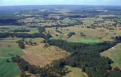 Irrigation and cropping of undulating plains and rises for dairy farming is common throughout the landscape |
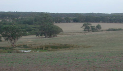
0.78% of CMA region From Princetown, stretching northwards, an undulating plain can be found extending up into the catchment of Kennedys Creek. The southern parts consist of a series of northnorth- west and south-south-east orientated ridges, but the major part of the unit is a plain with a dendritic drainage pattern. The higher parts of the landscape have deeply weathered soils with yellow and red mottles. Most slopes, however, carry heavier textured soils with dark coloured and coarsely structured subsoils. They extend up to the crests ridges in many areas; less weathered profiles occupy the lower parts of the landscape. This pattern resembles that found in many other soil-landforms on Paleogene sediments. The distinguishing features here are the dominance of the coarsely structured soils in the landscape, and the absence of ferruginised cappings. Dairy farming is the main land use with pine and blue gum plantations; with only small areas remain under native forest. The coarsely structured subsoils are dispersible and gully and tunnel erosion have occurred. On recently cleared areas, particular care is needed to prevent active gullies from being initiated. Landslips also occur on these soils. | 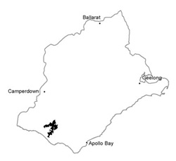 |
Blue gum and pine plantations are dominant with dairy farming across this landscape | 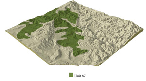 |
 |  Soils on gentle rises here are particularly prone to pugging by dairy cattle |
Component | 1 | 2 | 3 | 4 |
Proportion of soil-landform unit | 20% | 65% | 6% | 9% |
| CLIMATE Rainfall (mm) | Annual: 950-1050, lowest January (40), highest August (130) | |||
| Temperature (oC) | Annual: 13, lowest July (8.5), highest February (18) | |||
| Precipitation less than potential evapotranspiration | Temperature: less than 10oC (av.) June-August Precipitation: less than potential evapotranspiration November-March | |||
| GEOLOGY Age and lithology | Neogene marine marl and calcarenite; Paleogene marine carbonaceous marl, siltstone, sandstone and minor | Recent clay, sand and gravel | ||
| Geomorphology | ||||
| LANDUSE | Cleared areas: Dairy farming; beef cattle and sheep grazing; pine and blue gum plantations; water supply Uncleared areas: Water supply; hardwood forestry; nature conservation | |||
| TOPOGRAPHY Landscape | Undulating plain | |||
| Elevation range (m) | 15-150 | |||
| Local relief (m) | 70 | |||
| Drainage pattern | Predominantly dendritic with some trellis | |||
| Drainage density (km/km2) | 3.0 | |||
| Landform | Gentle rises | Alluvial terraces | ||
| Landform element | Upper slope and crest | Middle slope | Lower slope | |
| Slope and range (%) | 9 (4-15) | 10 (4-20) | 10 (7-35) | 5 (1-9) |
| Slope shape | Convex | Straight | Concave | (Varialbe - mostly straight) |
| NATIVE VEGETATION Ecological Vegetation Class | Open forest | Open forest | Open forest | Woodland |
| Dominant species | E. obliqua, E. viminalis, occasionally E. ovata | E. aromaphloia, E. viminalis, E. obliqua, E. raidata, E. ovata | E. obliqua, E. radiata occasionally E. viminalis | E. ovata, E. obliqua, E. viminalis |
| SOIL Parent material | Clay and silt | Clay and silt | Clay and silt | Alluvial clay, silt and sand |
| Description (Corangamite Soil Group) | Mottled brown, grey, yellow and red gradational soils (17) | Mottled brown, yellow and grey gradational soils (34) | ||
| Soil type sites | OTR746, OTR41 | CLRA9, OTR750 | - | |
| Surface texture | Fine sandy loam | Fine sandy loam | Fne sandy loam | Sandy loam |
| Permeability | Moderate | Low | Moderate | Low |
| Depth (m) | >2 | >2 | >2 | >2 |
| LAND CHARACTERISTICS, POTENTIAL AND LIMITATIONS | Low inherent fertility phosphorus fixation and steep slopes lead to sheet erosion and nutrient decline. | High dispersible clay subsoils are prone to gully and tunnel erosion. Periodic saturation leads to landslips. Steeper slopes are prone to sheet erosion of nutrient-rich surface horizons. | Steeper slopes are prone to sheet erosion. Dispersible clay susbsoils on moderately steep slopes are prone to gully erosion. | Dispersible clay subsoils of low permeability are prone to gully erosion. high watertables lead to seasonal waterlogging and soil compaction. |
© State of Victoria (Agriculture Victoria) 1996 - .

This work, Victorian Resources Online, is licensed under a Creative Commons Attribution 4.0 licence. You are free to re-use the work under that licence, on the condition that you credit the State of Victoria (Agriculture Victoria) as author, indicate if changes were made and comply with the other licence terms.
The licence does not apply to ‘branding’ or some ‘images or photographs’ that may be owned by third parties. We ask you to seek prior approval to use images using the VRO feedback form. Access to higher quality images can also be provided on request.
This page was last updated on .