
Soil/Landform Unit 92
Landform Unit Description
Page top
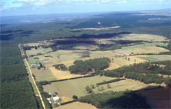 Gentle undulating plains with defined dissection at the base of the Otway Ranges near Irrewillipe |
0.78% of CMA region Adjacent to the ferruginised plateau around Simpson and at a similar elevation, a gently undulating plain without ferruginous ironstone extends eastwards towards Barongarook. The parent material is mainly Neogene sand and clay, with some minor redistribution on sand veneers in parts, and outcrops of deeply weathered Cretaceous sandstone along the sides of some of the drainage lines. The soils exhibit similar mottling and deep weathering to those found in Unit 181, and are prone to nutrient deficiencies and phosphate fixation. Open forests of Eucalyptus obliqua occur over most of the landscape, although E. baxteri tends to dominate on the polygenetic soils with hardpans. Acacia mucronata acts as a strong indicator of the presence of Cretaceous outcrops. Most areas remain uncleared and are selectively logged for hardwood timber, although most timber is of insufficient size to provide good sawlogs. | 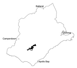 |
 Cleared land combined with dispersible subsoils are particularly prone to gully erosion | 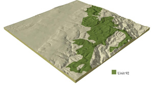 |
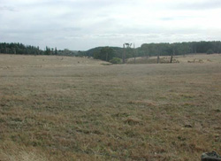
 |  Native vegetation of lower slopes |
Component | 1 | 2 | 3 | 4 | 5 |
Proportion of soil-landform unit | 45% | 7% | 25% | 15% | 8% |
| CLIMATE Rainfall (mm) | Annual: 850-950, lowest January (40), highest August (20) | ||||
| Temperature (oC) | Annual: 13, lowest July (8), highest February (18) | ||||
| Seasonal growth limitations | Temperature: less than 10oC (av.) June-August Precipitation: less than potential evapotranspiration late October-March | ||||
| GEOLOGY Age and lithology | Paleocene marine unconsolidated clay, silt and sand | Lower Cretaceous feldspathic sandstone and siltstone | |||
| Geomorphology | |||||
| LANDUSE | Uncleared areas: Hardwood forestry for sawlogs, posts and poles; water supply; nature conservation; gravel extraction Minor cleared areas: Beef and cattle grazing; dairy farming | ||||
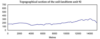
| TOPOGRAPHY Landscape | Undulating plain in the north of the Gellibrand River catchment | ||||
| Elevation range (m) | 120-340 | ||||
| Local relief (m) | 30 | ||||
| Drainage pattern | Parallel and dendritic | ||||
| Drainage density (km/km2) | 1.2 | ||||
| Landform | Undulating plain | ||||
| Landform element | Crest and upper slope | Colluvial fans and depressions | Slopes | Lower slopes | Lower slope and drainage line |
| Slope and range (%) | 7 (0-12) | 4 (0-7) | 7 (1-16) | 10 (4-14) | 10 (4-14) |
| Slope shape | Convex | Concave | Convex | Linear | Linear |
| NATIVE VEGETATION Structure | Open forest | Open woodland | Open forest | Open forest | Open forest |
| Dominant species | E. obliqua, E. radiata, E. baxteri, occasionally E. ovata, E. viminalis, E. aromaphloia | E. baxteri, E. ovata, E. nitida | E. baxteri, E. radiata, E. ovata, E. obliqua, occasionally E. aromaphloia | E. obliqua, E. radiata, E. ovata, E. baxteri | E. obliqua, E. ovata, E. radiata, E. aromaphloia |
| SOIL Parent material | Clay, silt and sand | Colluvial sand on sand, silt and clay | Colluvial sand on sand, silt and clay | Clay, silt and sand | In situ weathered sandstone and siltstone |
| Description (Corangamite Soil Group) | Grey sand soils, weakly structured clay underlay (29) | Grey sand soils, structured clay underlay (29) | |||
| Soil type sites | - | OTR742 | OTR737 | OTR750 | OTR750 |
| Surface texture | Sandy loam | Sandy loam | Sandy loam | Sandy loam | Fine sandy clay loam |
| Permeability | Moderate | Low | Low | Low | Low |
| Depth (m) | >2 | >2 | >2 | >2 | 1.5 |
| LAND CHARACTERISTICS, POTENTIAL AND LIMITATIONS | Low inherent fertility and phosphorus fixation lead to nutrient decline. | Low permeability and perched watertables lead to seasonal waterlogging and soil compaction. | Low inherent fertility and leaching of permeable surfaces lead to nutrient decline. Low permeabilities lead to seasonal waterlogging and soil compaction. | Dispersible clay subsoils of low permeability are prone to gully erosion. Steeper slopes are prone to sheet erosion. | Dispersible subsoils receiving runoff from adjacent areas are prone to gully erosion. |
© State of Victoria (Agriculture Victoria) 1996 - .

This work, Victorian Resources Online, is licensed under a Creative Commons Attribution 4.0 licence. You are free to re-use the work under that licence, on the condition that you credit the State of Victoria (Agriculture Victoria) as author, indicate if changes were made and comply with the other licence terms.
The licence does not apply to ‘branding’ or some ‘images or photographs’ that may be owned by third parties. We ask you to seek prior approval to use images using the VRO feedback form. Access to higher quality images can also be provided on request.
This page was last updated on .