
Soil/Landform Unit 93
Landform Unit Description
Page top
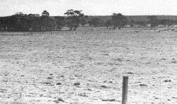
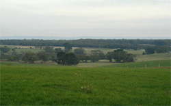 Rolling plains from Robinsons Road near Barongarook |
0.58% of CMA region North of Forrest and extending towards Colac, undulating plains with often deeply weathered soils are found. The geology is mainly Pliocene clay with minor outcrops of sand. Redistribution of surface sand has resulted in polygenetic soils over much of the landscape, with weak hardpan development and impeded drainage. Surface soils seem to be naturally low in plant nutrients. Many areas remain uncleared and support open forests dominated by Eucalyptus obliqua and E. radiata. E. baxteri is notably absent in this slightly drier region. Other areas have been cleared for agriculture or converted to pine plantations. The main hazards to land use are loss of soil structure by compaction and leaching of nutrients. |  |
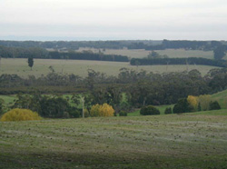 Cultivated crest and upper slope overlooing lower slopes and plains |  |
 |  Poor site drainage and low soil permeability lead to waterlogging and pugging of the soil by stock |
Component | 1 | 2 | 3 | 4 | 5 |
Proportion of soil-landform unit | 8% | 55% | 15% | 15% | 7% |
| CLIMATE Rainfall (mm) | Annual: 700-900, lowest January (40), highest August (80) | ||||
| Temperature (oC) | Annual: 13, lowest July (8), highest February (18) | ||||
| Seasonal growth limitations | Temperature: less than 10oC (av.) June-August Precipitation: less than potential evapotranspiration late October-early April | ||||
| GEOLOGY Age and lithology | Pliocene unconsolidated clay, silt and sand. Recent sand veneer | ||||
| Geomorphology | |||||
| LANDUSE | Cleared areas: Sheep and beef cattle grazing dairy farming Uncleared areas: Hardwood forestry for sawlogs, post and poles; nature conservation; active and passive recreation; softwood forestry, forest grazing | ||||
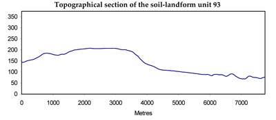
| TOPOGRAPHY Landscape | Gently undulating to rolling plain in the western parts of the Barwon catchment | ||||
| Elevation range (m) | 120-280 | ||||
| Local relief (m) | 30 | ||||
| Drainage pattern | Dendritic | ||||
| Drainage density (km/km2) | 1.2 | ||||
| Landform | Undulating plains | ||||
| Landform element | Steep slope | Crest, upper slope | Upper and middle slope | Lower slope | Drainage line |
| Slope and range (%) | 25 (15-40) | 15 (0-10) | 5 (0-10) | 7 (1-15) | 1 (0-2) |
| Slope shape | Linear | Convex | Convex | Linear | Concave |
| NATIVE VEGETATION Structure | Open forest | Open forest | Open forest | Woodland | Woodland |
| Dominant species | E. obliqua, E. radiata, E. viminalis | E. obliqua, E. radiata, occasionally E. ovata, E. viminalis | E. radiata, E. obliqua, E. nitida | E. radiata, E. nitida | E. ovata, E. radiata, occasionally E. aromaphloia |
| SOIL Parent material | Clay, silt and sand | Clay, silt and sand | Clay, silt and sand with quartz sand veneer | Clay, silt and sand with quartz sand veneer | Alluvium |
| Description (Corangamite Soil Group) | Grey sand soils, structured clay underlay (8) | Grey sand soils, weakly structured clay underlay (8) | Mottled brown, grey or yellow gradational soils (34) | ||
| Soil type sites | OTR497, OTR741 | OTR737 | - (OTR742) | - (OTR739) | |
| Surface texture | Sandy loam | Loam | Sandy loam | Sandy loam | Loam |
| Permeability | High | Moderate | Low | Low | Moderate |
| Depth (m) | >2 | >2 | >2 | >2 | >2 |
| LAND CHARACTERISTICS, POTENTIAL AND LIMITATIONS | Steeper slopes with weak structured surfaces are prone to sheet erosion. | Low inherent fertility and phosphorus fixation lead to nutrient decline. | Low inherent fertility with leaching of permeable surface horizons leads to nutrient decline. | Low permeability and seasonal perched watertable lead to waterlogging and soil compaction. | High seasonal watertable leads to waterlogging and soil compaction. |
© State of Victoria (Agriculture Victoria) 1996 - .

This work, Victorian Resources Online, is licensed under a Creative Commons Attribution 4.0 licence. You are free to re-use the work under that licence, on the condition that you credit the State of Victoria (Agriculture Victoria) as author, indicate if changes were made and comply with the other licence terms.
The licence does not apply to ‘branding’ or some ‘images or photographs’ that may be owned by third parties. We ask you to seek prior approval to use images using the VRO feedback form. Access to higher quality images can also be provided on request.
This page was last updated on .