
Soil/Landform Unit 89
Landform Unit Description
Page top
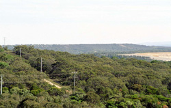 Dissected hills of the remnant ferrubinised plateau near Anglesea (top left is the township of Anglesea) |
0.63% of CMA region Stretching inland from the coast between Bells Beach and Moggs Creek lies a dissected plain of Paleogene sediments. Long straight slopes emanate from spurs and ridges. The coastal margins are retreating and often abut the sea as cliffs or massive landslips and earthflows. The parent material is variable, ranging from ferruginised sediments on the ridges to relatively unweathered alluvium in the drainage lines. Thus the soils are particularly variable. In general, plant nutrient levels are low and surface horizons are weakly structured. Plant communities are mainly open forests less than 15 m in height; the height decreases towards the coast under the influence of salt-bearing winds. The area is highly regarded for its diversity of flora. Some parts have been cleared for agriculture. The main hazards to land use are gully erosion and sheet erosion. |  |
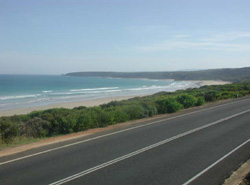 Long slopes retreating to coastal margins with steep cliffs | 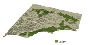 |
 | 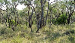 Vegetation of the remnant plateau |
Component | 1 | 2 | 3 | 4 | 5 | 6 | 7 |
Proportion of soil-landform unit | 25% | 5% | 10% | 30% | 25% | 2% | 3% |
| CLIMATE Rainfall (mm) | Annual: 600-800, lowest January (35), highest August (80) | ||||||
| Temperature (oC) | Annual: 14, lowest July (9), highest February (17) | ||||||
| Seasonal growth limitations | Temperature: less than 10oC (av.) july Precipitation: less than potential evapotranspiration mid October-early April | ||||||
| GEOLOGY Age and lithology | High variable Paleogene sediments consisting mainly of unconsolidated clayey silt, sand, gravel, tuff, tuff breccia also groundwater ironstone and sandstone | ||||||
| Geomorphology | |||||||
| LANDUSE | Uncleared areas: Nature conservation; active and passive recreation; landscape conservation; gravel extraction Cleared areas: Beef cattle grazing on mainly unimproved pastures; residential; active recreation | ||||||
| TOPOGRAPHY Landscape | Moderately dissected hills lying below and on the seaward side of the ferruginised plateau | ||||||
| Elevation range (m) | 0-195 | ||||||
| Local relief (m) | 50 | ||||||
| Drainage pattern | Rectangular | ||||||
| Drainage density (km/km2) | 2.7 | ||||||
| Landform | Hills | ||||||
| Landform element | Exposed coastal slope | Slope and crest | Lower slope and drainage line | Middle slope | Upper slope and crest | Steep slope | Landslip |
| Slope and range (%) | 20 (5-45) | 9 (5-15) | 8 (1-15) | 15 (5-35) | 10 (1-20) | 45 (25-55) | (5-90) |
| Slope shape | Linear/irregular | Linear | Concave | Convex | Convex | Linear | Irregular |
| NATIVE VEGETATION Structure | Open forest | Open forest | Low woodland (variable) | Open forest | Open forest | Open forest | Tall woodland |
| Dominant species | E. obliqua, Casuarina stricta, E. sideroxylon | E. viminalis, E. radiata, E. baxteri | E. sideroxylon, E. obliqua | E. sideroxylon, E. obliqua | E. obliqua, E. sideroxylon, E. baxteri | E. obliqua, E. baxteri, E. sideroxylon | E. sideroxylon, E. obliqua, Melaleuca lanceolata, Casuarina stricta |
| SOIL Parent material | Calcareous sand, clay, silt, sand and gravel | Sand and gravel | Clay, silt and gravel | Clay, silt and sand, sandstone | Deeply weathered clay, silt and sand | Lateritic ironstone, sandstone | Clay, silt and sand; some aeolian sand |
| Description (Corangamite Soil Group) | Grey sand soils (29) | Stony red gradational soils (29) | Variable sodic texture contrast soils (27) | ||||
| Soil type sites | - | OTR742 | OTR492, OTR744 | - | - | ||
| Surface texture | Sandy loam | Loamy sand | Fine sandy loam | Fine sandy loam | Sandy loam | Sandy loam | Sandy loam |
| Permeability | Moderate | Very high | Very low | Very low | Moderate | Very high | Moderate |
| Depth (m) | >2 | >2 | >2 | >2 | >2 | 0.2 | >2 |
| LAND CHARACTERISTICS, POTENTIAL AND LIMITATIONS | Native vegetation is sensitive to salt pruning and disturbance. Highly dispersible soils on steep slopes are prone to sheet erosion, gully and tunnel erosion. | Very low inherent fertility and high permeability lead to nutrient decline. | Sodic, highly dispersible subsoils are prone to gully and tunnel erosion. | Highly dispersible soils are prone to gully and tunnel erosion. Weakly structured surface soils over slowly permeable subsoils on steep slopes are prone to sheet erosion. | Low inherent fertility, phosphorus fixation and leaching of permeable A horizons lead to nutrient decline. | Stony shallow soils with low organic content, weak structure and low waterholding capacity on steep slopes are prone to sheet erosion. | Native vegetation is sensitive to salt pruning and disturbance. Marine under-cutting of highly dispersible soils maintains active landslips and earth flows. |
© State of Victoria (Agriculture Victoria) 1996 - .

This work, Victorian Resources Online, is licensed under a Creative Commons Attribution 4.0 licence. You are free to re-use the work under that licence, on the condition that you credit the State of Victoria (Agriculture Victoria) as author, indicate if changes were made and comply with the other licence terms.
The licence does not apply to ‘branding’ or some ‘images or photographs’ that may be owned by third parties. We ask you to seek prior approval to use images using the VRO feedback form. Access to higher quality images can also be provided on request.
This page was last updated on .