
Soil/Landform Unit 86
Landform Unit Description
Page top
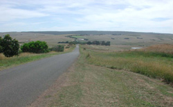 View north towards Fergusons Hill |
0.51% of CMA region Most outcrops of Neogene sediments to the west of the Otway Range are either steeply dissected or have deeply weathered soils. However, some ridges and spurs are only mildly dissected and their soil profiles are only weakly developed. These areas are found at Ferguson Hill, just south of Simpson, along Pipeline Road and in an additional small area near Cape Otway. The parent material is Neogene sand, silt and clay, with some minor areas of ferricrete. The soils vary according to the nature of the outcropping beds, but in general their structure is weak and often the A and B horizons are not clearly differentiated. Profile drainage is good on all but those areas with hardpans, and these are the only areas prone to waterlogging despite the high annual rainfall. Eucalyptus obliqua and E. baxteri colonise most areas and often reach heights in excess of 30 m on the better drained soils. However, these stands are decreasing in area as much of the land is being cleared for agriculture. The soils are naturally quite stable and the major problems are likely to arise from nutrient decline. |  |
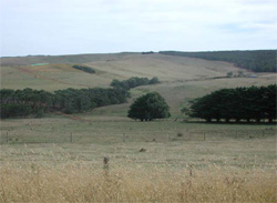 Slopes with devined dendritic drainage on southern slopes of Ferguson Hill | 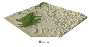 |
 | 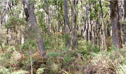 Woodlands of the broad ridge of Ferguson hill |
Component | 1 | 2 | 3 | 4 | 5 | 6 | 7 | 8 |
Proportion of soil-landform unit | 15% | 20% | 25% | 5% | 8% | 15% | 10% | 2% |
| CLIMATE Rainfall (mm) | Annual: 1000-1100, lowest January (4), highest August (130) | |||||||
| Temperature (oC) | Annual: 13, lowest July (7.5), highest February (9) | |||||||
| Seasonal growth limitations | Temperature: less than 10oC (av.) June-August Precipitation: less than potential evapotranspiration mid November-March | |||||||
| GEOLOGY Age and lithology | Paleogene marine carbonaceous clay to sand, Neogene fluvio-marine sand and marine marl. | |||||||
| Geomorphology | ||||||||
| LANDUSE | Uncleared areas: Hardwood forestry for sawlogs, posts and poles; water supply; nature conservation; gravel extraction Cleared area: Sheep and beef cattle grazing; dairy farming; water supply | |||||||
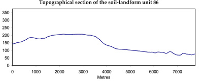
| TOPOGRAPHY Landscape | Undulating hills and ridges | |||||||
| Elevation range (m) | 30-230 | |||||||
| Local relief (m) | 40 | |||||||
| Drainage pattern | Dendritic | |||||||
| Drainage density (km/km2) | 1.7 | |||||||
| Landform | Hills | Drainalge lines | Broad ridges | Scarps | ||||
| Landform element | Lower slope | Slope | Crest | Midslope | - | Crest and upper slope | Crest | - |
| Slope and range (%) | 4 (1-7) | 14 (5-37) | 5 (2-9) | 11 (3-15) | 4 (2-9) | 4 (0-11) | 4 (0-7) | 29 (25-37) |
| Slope shape | Straight | Straight | Convex | Straight | Concave | Convex | Straight | Concave |
| NATIVE VEGETATION Structure | Open forest | Open forest | Low woodland (variable) | Open forest | Open forest | Open forest | Tall woodland | Open forest |
| Dominant species | E. obliqua, E. ovata | E. baxteri, E. nitida, E. obliqua | E. nitida, E. baxteri | E. baxteri, E. radiata, E. obiqua, E. cypellocarpa | E. obliqua, E. baxteri | E. baxteri, E. obliqua | E. baxteri, E. obliqua | E. obliqua, E. baxteri, E. ovata, Acacia malanoxylon |
| SOIL Parent material | Clay and silt | Clay, silt and sand | Sand | Sand, silt and clay | Alluvial sand, silt and clay | Clay and silt; some lateritic remnants | Clay and silt; some lateritic remnants | Colluvial lateritic ironstone |
| Description (Corangamite Soil Group) | Grey-brown gradational soils (29) | Yellow gradational soils, weak structure (29) | Grey sand soils with hardpans (29) | Red sandy loam soils (29) | Mottled brown, grey, yellow or red gradational soils (17) | Red gradational soils, weak strcture (17) | Stony red gradational soils (17) | |
| Soil type sites | OTR497, CLRA13 | - | OTR733, SW23 | OTR782 | OTR749 | - | ||
| Surface texture | Fine sandy loam | Sandy loam | Loamy sand | Sandy loam | Sandy loam | Sandy loam | Sandy loam | Gravelly loamy sand |
| Permeability | Moderate | High | Very low | Very high | Low | Moderate | High | Very high |
| Depth (m) | >2 | >2 | >2 | >2 | >2 | >2 | 0.9 | >2 |
| LAND CHARACTERISTICS, POTENTIAL AND LIMITATIONS | Minor hazards | Weakly structured surfaces on steeper slopes are prone to sheet erosion. Low inherent fertility and high permeability lead to nutrient decline. | Weakly structured sands on hardpans are prone to sheet erosion and seasonal watrlogging. Permeable surface sands of high acidity and low inherent fertility are prone to nutrient decline. | Low inherent fertility and high permeability lead to nutrient decline. | High seasonal watertable leads to soil compaction. | Low inherent fertility, phosphorus fixation and permeable surfaces lead to nutrient decline. | Low inherent fertility and high permeability lead to leaching of nutrients. | Steep slopes with weakly structured surface soils of low water holding capacity are prone to sheet erosion. |
© State of Victoria (Agriculture Victoria) 1996 - .

This work, Victorian Resources Online, is licensed under a Creative Commons Attribution 4.0 licence. You are free to re-use the work under that licence, on the condition that you credit the State of Victoria (Agriculture Victoria) as author, indicate if changes were made and comply with the other licence terms.
The licence does not apply to ‘branding’ or some ‘images or photographs’ that may be owned by third parties. We ask you to seek prior approval to use images using the VRO feedback form. Access to higher quality images can also be provided on request.
This page was last updated on .