
Salinity Provinces in the Goulburn Broken Catchment Management Region
The Goulburn-Broken CMA Region is situated in north central Victoria where it extends from near Woods Point in the Great Dividing Range to the Murray riverine plains in the north-west (near Echuca). The region has two river basins, the Goulburn River and Broken River.
Generally, the catchment experiences a warm temperate climate, with hot and relatively dry summers, and cool wet winters. Seasonal patterns show a marked winter rainfall incidence, with June typically the wettest month. Average annual rainfall ranges from less than 500 mm in the far north of the region to more than 1600 mm in the high country in the south.
Most of the catchment has been cleared for agriculture with intensive irrigation in the north and dryland farming enterprises in the south, such as sheep and cattle grazing, wool, wheat, barley and oat production.
Dryland salinity is one of the major natural resource management issues facing the middle parts of the catchment and threatens land, water and environmental assets in several sub-catchments (e.g. Kurkurac Creek, Dry Creek, Majors Creek, Whiteheads Creek, Sheep Pen Creek and Honeysuckle Creek). Dryland salinity is widespread with more than 720 individually mapped units1 recorded as saline with the approximate total area of 4670 hectares1 .
High watertables and salinity associated with irrigation development also threaten productivity and environmental values across the irrigated parts of the northern riverine plains. Dryland salinity is responsible for high salt loads feeding into some mid-catchment streams and is a major contributor to water quality and stream degradation in the River Murray system.
The region has a range of local, intermediate and regional Groundwater Flow Systems (GFS). Each of these GFS presents unique salinity problems. For better monitoring and reporting of salinity risk, 17 Salinity Provinces have been defined in the region, nine of which are High priority.
The Goulburn Broken CMA has an extensive range of online materials (maps and documents etc.) which outline the biophysical assets of the catchment, as well as their major risks (including soil and water salinity). This material also outlines the programs and projects currently being completed by the CMA to protect and enhance these assets. An example of this is the Goulburn Broken CMA ‘Published Documents’ resource, the link to which can be found at the base of this page.
Provinces displayed in this map are clickable or use the table of links provided
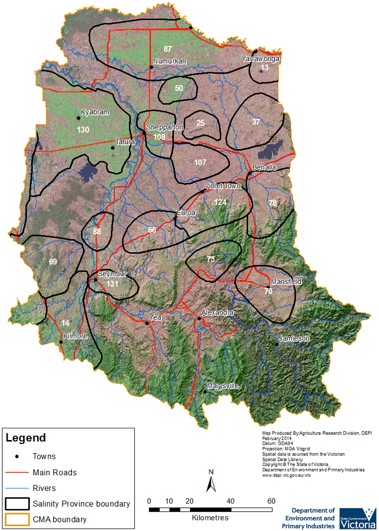
Province Name | No. | Area of Province (ha) | Recorded Soil Salinity Area 1 (ha) | Soil Salinity Area (% of SP) |
| Boomahnoomoonah | 13 | 22,030 | 0 | 0% |
| Broadford | 14 | 79,000 | 373 | 0.47% |
| Dookie | 25 | 19,780 | 47 | 0.24% |
| Goorambat - Devenish | 37 | 55,200 | 23 | 0.04% |
| Invergordon | 50 | 19,400 | 0 | 0% |
| Longwood | 66 | 46,700 | 64 | 0.14% |
| Majors Creek | 69 | 64,090 | 357 | 0.56% |
| Mansfield | 70 | 58,840 | 0 | 0% |
| Merton_Ancona | 73 | 34,310 | 0 | 0% |
| Molyullah_Tatong | 78 | 62,940 | 737 | 1.17% |
| Murray Valley | 87 | 171,860 | 0 | 0% |
| Nagambie | 88 | 21,230 | 0 | 0% |
| Sheep Pen Creek | 107 | 41,140 | 765 | 1.86% |
| Shepparton - Kialla | 108 | 32,360 | 33 | 0.10% |
| Warrenbayne - Boho | 124 | 63,260 | 1,074 | 1.70% |
| West Goulburn Plains | 130 | 182,430 | 0 | 0% |
| Whiteheads Creek | 131 | 24,910 | 137 | 0.01% |
1 Please Note: The ‘Recorded Soil Salinity Area’ and ‘number of individually mapped units’ indicated in the CMA text and/or table, comprises the total geographic area or number of sites that have been mapped as having, or showing symptoms of dryland soil salinity at some time (past or present). As dryland salinity occurrence in the Victorian landscape exhibits many different levels of severity and can change due to climate, landuse and vegetation, previously mapped areas may no longer be showing symptoms. In addition, as not all parts of the state have been mapped, or mapped in the same way, the mapping may not have captured some occurrences.
Recorded soil salinity mapping used for these pages does not cover irrigation regions. Instead, depth to watertable and watertable salinity mapping has been used to convey the threat of high watertables on soil waterlogging and/or soil salinisation.
Please contact the Department, your Catchment Management Authority or your rural water provider for more information about salinity in your location.
Links to further reading and material related to the Goulburn Broken CMR
Goulburn Broken Catchment Management Authority region on VRO
Goulburn Broken Catchment Management Authority
Goulburn-Broken CMA ‘Regional Catchment Strategy ’ (RCS)
Goulburn-Broken CMA ‘Published Documents’ (including those about Dryland Salinity)
Information about bores and groundwater resources in the Goulburn-Broken CMA can be found on the Visualising Victoria’s Groundwater (VVG) website
Relevant Information
© State of Victoria (Agriculture Victoria) 1996 - 2025.

This work, Victorian Resources Online, is licensed under a Creative Commons Attribution 4.0 licence. You are free to re-use the work under that licence, on the condition that you credit the State of Victoria (Agriculture Victoria) as author, indicate if changes were made and comply with the other licence terms.
The licence does not apply to ‘branding’ or some ‘images or photographs’ that may be owned by third parties. We ask you to seek prior approval to use images using the VRO feedback form. Access to higher quality images can also be provided on request.
This page was last updated on 23/03/2020.