
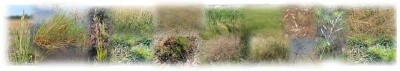
Salinity Indicator Plants - A guide to spotting soil salting
Purpose of this Guide | Using this Site | Soil Salinity Classes and Ranges | Waterlogging Classes | Glossary | Photo Gallery | Salinity Indicator Plants - Alphabetical Listing - Common Name and Scientific Name | Family Names listing - Common and Scientific | Key to Families and Genera represented in Salinity Indicator Plants
| Dryland soil salinity is a feature of parts of the Victorian landscape, particularly in the western and northern regions of the state but also in central Gippsland. It has been estimated to affect between 240,000 and 268,000 ha of land and to cost $50 million per annum in lost agricultural production (State of the Environment Report Feb 2009, Fact Sheet 6) and $1.8 billion in private and public management funding during the period 1990-2001 alone. The extent and severity of dryland salinity continues to require assessment as water-table levels, long-term weather patterns, landscape modification and land-use change. Although the drought years of the late 1990’s to the mid 2000’s saw a general fall in water-tables across Victoria accompanied by less expression of salinity in the landscape, the recent wetter seasons are expected to result in more salt mobility and surface salinity. |
Physical indicators of dryland salinity include groundwater discharge (free surface water or dampness during the summer), mid-slope seepage, bare soil, surface soil salt stains or crystals and soil blackening (organic matter staining). Apart from the latter two, these signs are not always indicative of salinity but may represent recent rainfall events, freshwater springs, overgrazing or trafficking. However, the use of indicator plant species has been commonly employed in combination with physical indicators to assist in dryland salinity assessment.
Plant species have different tolerances to soil and water salinity levels. Salt-tolerant species have physiological mechanisms, such as salt exclusion, intraplant salt translocation (e.g. from sensitive shoots to older leaves or roots), cellular osmotic adjustment (i.e. dilution by increasing water uptake), salt intracellular compartmentation (i.e. accumulation in the spaces between cells) or salt excretion (e.g. through salt glands) that allow them to cope with high environmental salt concentrations. Salt-sensitive species do not have these (or maybe not all of these) coping mechanisms and therefore succumb to wilting due to decreased water uptake, inhibited growth and eventual death, depending on the salt levels encountered and the particular species tolerance level. As a consequence, as soil salinity increases, vegetation becomes more dominated by the more salt-tolerant species. Contrary to popular belief, most salt-tolerant species are not dependent on salt to survive but are often only found in saline conditions. This is because, in non-saline or low salt environments, salt-sensitive species are generally more vigorous than salt-tolerant species and out-compete with them for water and nutrients.
A number of plant species however, grow vigorously in both non-saline and saline environments; available moisture appearing to be the main criterion for their dominance. Therefore, the presence of these species on a site may not be related to salinity but merely to a seasonally or permanently wet site. Common species in this category include; Water Buttons (Cotula coronopifolia), Beard Grass (Polypogon monspeliensis), Buck’s-horn Plantain (Plantago coronopus), Spiny Rush (Juncus acutus) and Common Blown-grass (Lachnagrostis filiformis). For some of these species, increasing salt may increase their presence on site, while for others, increasing salt may decrease their dominance or change their appearance. For example, the leaves of Buck’s-horn Plantain generally become red as salt stress increases. It is important to examine the whole of the vegetation present on a site and look for physical indicators before determining if salinity is present or not.
Dryland salinity is often divided into Primary and Secondary types. Primary or natural salinity existed long before European settlement and is considered to be the result of natural landscape processes. Secondary or induced salinity has occurred since European settlement and is considered to be the result of changes in land and water management practices. Primary salinity can be classified into i) salt marshes and saline swamps, ii) salt lakes, iii) salt flats, playa and salt pans and iv) natural salt springs, seepages and drainage lines. Each of these classes tend to support a particular suite of plant species. In relatively unmodified Primary salinity environments, the major species present are Australian perennial natives. In Secondary saline environments, which have generally been extensively modified, introduced annual species tend to dominate the vegetation.
The role of rainfall amount and seasonal pattern, soil drainage and water retention and subsequent soil moisture is significant in terms of the expression of salt-tolerance, even among salt-sensitive plant species. In high rainfall, low evaporation, well-drained soil environments, salt can be leached from the soil profile during storm events. Under these conditions, plant species can often tolerate higher levels of soil and water salinity than where seasonal growth periods are short and salt accumulates as evaporites on dense clay surface soils. The same species may have less tolerance in the latter situation than in the former. The same is generally true for germination rates and early seedling growth of recruitment plants. Even the most salt-tolerant plant species, generally require seasonal salt leaching and therefore lowering of surface soil salinity before germination can occur.
Not only does soil salt concentration on a site vary depending on the season of the year (i.e. lowest with winter and spring rainfall and highest with summer drought), most saline sites are variable in terms of salt distribution across their surfaces. Slightly elevated areas may have a lower salt level than slightly depressed areas. Sandier surfaces may allow more rapid leaching of salt than clay surfaces. Salt-tolerant bushes and shrubs may provide enough organic litter below their canopy to allow sufficient salt dilution for the successful germination of more salt-sensitive species. As a consequence of this variation, it is not uncommon to find a mosaic of plant species of varying salt-tolerance across a site. In particular, annual salt-sensitive species with a short growing cycle (e.g. Soft Brome, Silver Grass, Burr Medic, Capeweed) can often establish on a saline site, grow rapidly to maturity and set and disperse seed before the extreme stress of summer salt concentration sets in.
Because salt is highly soluble in water and is transported by such, saline environments are often also wet environments, or at least seasonally wet. As well as varying in salt-tolerance, plant species also vary in waterlogging tolerance. Species can be salt- and waterlogging sensitive (e.g. Kangaroo Grass) or salt- and waterlogging tolerant (e.g. Australian Salt-grass) or salt-sensitive and waterlogging tolerant (e.g. Swamp Wallaby-grass) or salt-tolerant and waterlogging intolerant (e.g. Coast Blown-grass) or with varying degrees of salt-tolerance and waterlogging tolerance. However, salt-tolerance can also vary for a particular species, depending on the duration of waterlogging. The interrelationship between salinity and waterlogging for many species is often unclear or yet to be studied. Nevertheless, a knowledge of waterlogging on a site undergoing salinity assessment is an important aspect to take into consideration when examining the suite of plant species present.
The following web pages describe both Australian and introduced plant species commonly found on Primary or Secondary salinity sites throughout Victoria. They provide some basic plant descriptions and notes on likely habitat to assist the reader in classifying the severity of salinity at a site under investigation. This guide should not be used as a final arbitrator of soil salinity class (that being the role of laboratory soil and water testing) but can be useful as a first stage of assessment, particularly for broad-scale mapping exercises (see Method for field assessment of dryland salinity in Victoria using GPS technology). In addition, common salt-sensitive plants associated with wetlands and coastal plants tolerant of salt-spray are also included in this guide.
Purpose of this Guide
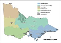
The original Spotting Soil Salting field guide was conceived as a statewide guide that could be used to identify some of the common salt tolerant plants found across Victoria and assign a salinity rating based on the plants present. However, salinity indicators vary across the state. For example plants found at saline sites in north west Victoria may not be present at discharge sites in the Western District. This version of the field guide aims to provide reference material for specific regions of the state.
Because of the wide range in salinity tolerance for many of the listed species, this guide is a much a guide to identification of plants on saline sites as a list of specific species associated with a particular salt class.
Using this Site
This site provides information, using photos and descriptive text, to guide you in recognising common plants associated with saline environments. The guide is divided into major regions across Victoria where the same or a similar range of plant species exhibiting a consistent response to salinity might occur. Note that not all listed plants for your region may be found in your particular district. Other factors, such as soil type, climate, topography, flooding frequency and duration and land management and history will have a role in determining which species grow where.
Within each region, separate lists of soil-salinity tolerant plants and salt-sensitive wetland plants are provided. For the coastal region, instead of wetland plants, a list of salt-spray tolerant plants is included. Each species in the lists has a separate page which provides, as well as photographs, other scientific names (synonyms), other common names, where the species is native to, a simplified plant description and notes on habitat (including salt tolerance and waterlogging tolerance). As the site is continually undergoing review, you may find updates or additional information on each visit.
While some plants will be easily recognised from the photographs, others may need reference to the descriptive text, drawings, plant keys and definitions. But don't let this put you off. Identifying plants is like anything else: it gets easier with practice. Over time, you should be able to identify the most common species associated with salinity in your district and thereby recognize emerging salinity areas requiring further investigation with soil and/or groundwater analysis.
The steps to using this guide for the first time are as follows:
- Examine the photographs and descriptions associated with the salinity classes provided in the table below and determine which best suits the situation under investigation
- Choose the region of interest from the clickable list or map provided
- Focus on the plant species list associated with the salinity class you have determined
- Examine individual species by clicking on their common name
Alternately, if you already know the common or scientific name of a particular species of interest, you can use the Common Name or Scientific Name lists to go directly to the description page. Under Habitat, details of its regional distribution and tolerance to salinity and waterlogging are provided.
If, when reviewing a listed species, it is not the same as the one you are examining, check under Comments for references to similar species within the same family or click on the Family name to see a list of other family members included within this guide.
Soil Salinity Classes and Ranges
The following table provides approximate ranges for soil salinity classes used in this guide. For further information and photographs associated with these classes, click on the links within the table.
| Soil Salinity Class | ECe (dS/m) | EC 1:5 Sandy loams (dS/m) | EC 1:5 Clay loams to light clays (dS/m) | EC 1:5 Medium to heavy clays (dS/m) |
|---|---|---|---|---|
| S0 - Non Saline | < 2 | < 0.2 | < 0.2 | < 0.3 |
| S1 - Slightly Saline | 2 - 4 | 0.2 - 0.3 | 0.2 - 0.4 | 0.3 - 0.6 |
| S2 - Moderately Saline | 4 - 8 | 0.4 - 0.7 | 0.5 - 0.9 | 0.7 - 1.3 |
| S3 - Highly Saline | 8 - 16 | 0.8 - 1.5 | 1.0 - 1.8 | 1.4 - 2.7 |
| S4 - Extremely Saline | > 16 | > 1.5 | > 1.8 | > 2.7 |
Waterlogging Classes
The following table provides classes for waterlogging used in this guide. Tolerance to waterlogging relates to the length or duration of surface flooding (inundation). It is assumed that an inundated site will also have a saturated soil profile, although in very occasional situations where a dried-out soil profile has inherently poor drainage, flood waters may remained ‘perched’ on the surface for at least a short while.
| Waterlogging Class | Site Description | Examples | Common Surface Soil Condition |
|---|---|---|---|
| W0 – low tolerance | soil profile saturation and surface inundation over a few days at the most; no permanent near-surface water-tables | well-drained sites, short-term flooding due to storm events | Dry – plants appearing to grow in dry soil for the bulk of their growing season but usually their root systems are accessing water from a moist or damp subsurface or subsoil |
| W1 – restricted tolerance | sporadic and short-term inundation over a few weeks; no permanently saturated root-zones | flat land, flood-plains, drains, depressions | Moist – plants growing in widely fluctuating moisture conditions but surface soils (or at least subsurface soils) are never completely dry for more than a few weeks (unless drought affected) during the bulk of the growing season |
| W2 – good tolerance | seasonal and longer-term inundation over a few months; fluctuating water-tables | natural drainage lines, seepage slopes, river and creek flats, seasonal swamps | Damp – plants growing in or near a saturated soil surface or their roots accessing a saturated subsurface layer for the bulk of their growing season; may be dry post-flowering or during seed ripening |
| W3 – high tolerance | periodic or regular inundation; permanently high water-tables | tidal estuaries, marshes (fresh or salt), river banks, lake edges, channel banks | Wet – plants often growing in a shallow cover of standing water or within a mosaic of more or less permanent pools and saturated mounds |
| W4 – aquatic environments | permanent inundation for at least 10 months of the year | lake and river beds | Inundated – plants growing completely on water; non rooted (floating aquatics), completely under water; except for flowering parts (submerged aquatics) or partially under water; rooted in sediment but stems and leaves above water (emergent aquatics) |
© State of Victoria (Agriculture Victoria) 1996 - 2025.

This work, Victorian Resources Online, is licensed under a Creative Commons Attribution 4.0 licence. You are free to re-use the work under that licence, on the condition that you credit the State of Victoria (Agriculture Victoria) as author, indicate if changes were made and comply with the other licence terms.
The licence does not apply to ‘branding’ or some ‘images or photographs’ that may be owned by third parties. We ask you to seek prior approval to use images using the VRO feedback form. Access to higher quality images can also be provided on request.
This page was last updated on 23/03/2020.