
1.3 Landscapes below 500 m of low relief
1. Eastern Uplands (EU)
1.3.1 Low relief landscapes at low elevation (Cann River south, Silvan, Templestowe)
1.3.2 Enclosed landscapes of low relief (Murmungee, Omeo, Dargo, Buldah)
1.3.3 Terraces, fans and floodplains (Kiewa Valley, Wonnangatta Valley)
1.3.4 Karst with depressions (Buchan)
| This unit contains landscapes of low relief at the bottom of the geomorphological erosional sequence in the Eastern Uplands where further down-cutting of the drainage system is limited by regional base-levels, either sea level for the southern part of unit 1.3.1 where the coast is its southern margin, or more local base levels for the northern part and for units 1.3.2, 1.3.3 and 1.3.4. Unit 1.3.4 is distinctive because it is on a small outcrop of Devonian limestone, relatively rare in the Eastern Uplands, and has many characteristic kast features. On the southern side of the Eastern Uplands this landscape occurs as a dissected plateau-like surface known as the Nillumbik Terrrain. It extends from the eastern suburbs of Melbourne (e.g. Camberwell and Templestowe) around Mt Dandenong (including Silvan and Wandin) through Gembrook and as far east as Bairnsdale. It may extend further eastwards as gravel-capped flattened spurs fringing the higher uplands to Cann River and even beyond. | 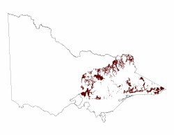 |
Unit 1.3.3 consists predominantly of the alluvial sediments of the flood plains and terraces that have accumulated in the lower reaches of the main streams, and colluvial material of the fans that form the apron between generally planar alluvial landscape and the steeper, confining valley-side slopes. The remainder of this Tier is formed on predominantly Palaeozoic sedimentary rocks and some granitic igneous rocks.
The confined alluvial terraces, fans and floodplains (1.3.3) make up the landscapes of the lowest parts of the Eastern Uplands where they merge with the extensive (unconfined) floodplains and terraces of the Northern Riverine Plains (Tier 4) and the Eastern Plains (Tier 7). The boundary between these and the Eastern Uplands is largely drawn to include the remnants of the major drainage divides represented by the low hills and ridges of Tier 1.4.5 and 1.4.6 that still reflect the confining structures that typify this Tier.
Related information on VRO
- A Study of the Land in the Catchment of the Kiewa River (R K Rowe 1972)
- A Study of the Land in the Buffalo National Park (R K Rowe 1970)
- A Study of the Land in the Upper Ovens and King Rivers ( R K Rowe 1952)
- A Study of the Land in the Victorian Catchment of Lake Hume (R K Rowe 1967)
- A Study of the Land in the Catchment of Gippsland Lakes, Volume 1 (J M Aldrick 1988)
- A Study of the Land in the Catchment of Gippsland Lakes, Volume 2 (J M Aldrick 1988)
- Land Inventory of East Gippsland - A Reconnaissance Survey Technical Report No. 23 (D B Rees, 1996)
- A Study of the Land in the Catchment of Lake Eildon (A S Rundle 1977)
- Land Resource Assessment in the Western part of the Shire of Towong (R Hook and D Rees 1999)
- Reconnaissance Survey of the Middle Reaches of the Goulburn River Catchment (Edited by L A White 1990)
© State of Victoria (Agriculture Victoria) 1996 - .

This work, Victorian Resources Online, is licensed under a Creative Commons Attribution 4.0 licence. You are free to re-use the work under that licence, on the condition that you credit the State of Victoria (Agriculture Victoria) as author, indicate if changes were made and comply with the other licence terms.
The licence does not apply to ‘branding’ or some ‘images or photographs’ that may be owned by third parties. We ask you to seek prior approval to use images using the VRO feedback form. Access to higher quality images can also be provided on request.
This page was last updated on .