
1.1.2 Broad ridges, plateaux (Hotham-Lock Ridge, Mt Fainter Ridge, Barry Mountains, Davies Plain)
1. Eastern Uplands (EU)
1.1.1 Summit plateaux (Mt Bogong, Baw Baw, Buffalo, Mt Wills)
1.1.2 Broad ridges, plateaux (Hotham-Lock Ridge, Mt Fainter Ridge, Barry Mountains, Davies Plain)
1.1.3 Enclosed landscapes of low relief (Horsehair Plain)
1.1.4 Capped (basalt) plains (Mt Jim-Bogong High Plains, Dargo Plains, Nunniong Plains)
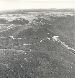
| The broad ridges with flattened or rounded crests which characterise Tier 1.1.2 are sometimes extensions from the plateau surfaces of Tier 1.1.1, but in other cases they are not connected with these. Elevations are mostly from 1 200-1 600 m. This unit includes the Mt. Fainter ridge and the Hotham Tablelands that is the largest element of this group. The latter area comprises the rounded ridge summits surrounding Mt. Hotham (1 862 m), which rises above the general tableland level of about 1 530 m. Rounded ridges extend to Mt Loch (1 875 m). East of Mt. Hotham the broad, rounded ridge summits change to a flat tableland topography, also known as the Paw Paw Plains (1 400-1 530 m), on the Cobungra-Dargo divide, with Mt Tabletop (1 588 m) as the highest point. A contiguous tableland declines eastwards along the Cobungra-Victoria divide towards Cobungra. The tableland topography partly results from the presence of flat basalt cappings (Older Volcanics). These areas are included in Tier 1.1.4. South of Mt Howitt, the ridge connecting the summit plains (e.g. Howitt and Bryces Plains) and the Snowy Range extending south towards Mt. Wellington are formed in gently dipping Upper Devonian sandstone. Elevations are between 1 420 m and 1 640 m, with the heads of some streams orientated along the strike of the Upper Devonian rocks. |  |
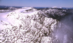 Barry Mountains | The Mt Gibbo area consists of a broad divide of about 1 530 m elevation, with gentle rises and falls; Davies Plain is the only significant flat area on the Davies Plain Ridge. The steep valleys of the Indi River and Gibbo Creek lie about 900 m below. The highest points are the broad summits of Mt Gibbo (1 757 m) and Mt Pinnibar (1 771 m). The many of the landscapes of this group are remnants of the high plateaus that have survived the encroachment of the stream dissection and slope retreat that has created the mountainous steep ridge and valley landscape of Tier 1.4.4 that is one of the defining features of the Eastern Uplands. Eventually, slope retreat on either side of the ridge destroys the ancient surface and narrow ridge-crests are formed. Often the continuity of a broad ridge is interrupted where retreating slopes have met to form a saddle in a ridge at a lower elevation. Because of their narrow width, these landscapes do not usually have clearly defined drainage lines. They are therefore somewhat drier than the plateau landscapes, and although the soils are similar to those of Tier 1.1.1 the peat soils of the fens and moss beds are usually absent apart in high flatter areas. | 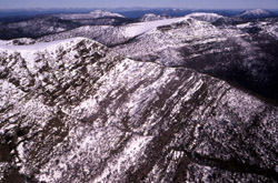 Barry Mountains |
 Bogong High Plains & Mt McKay | 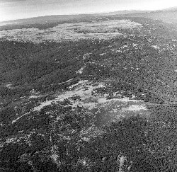 Broad Ridge & Basalt Plains | 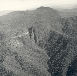 Cobbler Plateau & Mt Cobbler |
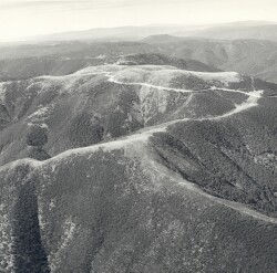 Mt Hotham & Razorback |
© State of Victoria (Agriculture Victoria) 1996 - .

This work, Victorian Resources Online, is licensed under a Creative Commons Attribution 4.0 licence. You are free to re-use the work under that licence, on the condition that you credit the State of Victoria (Agriculture Victoria) as author, indicate if changes were made and comply with the other licence terms.
The licence does not apply to ‘branding’ or some ‘images or photographs’ that may be owned by third parties. We ask you to seek prior approval to use images using the VRO feedback form. Access to higher quality images can also be provided on request.
This page was last updated on .