
1.1.1 Summit plateaux (Mt Bogong, Baw Baw, Buffalo, Mt Wills)
1. Eastern Uplands (EU)
1.1.1 Summit plateaux (Mt Bogong, Baw Baw, Buffalo, Mt Wills)
1.1.2 Broad ridges, plateaux (Hotham-Lock Ridge, Mt Fainter Ridge, Barry Mountains, Davies Plain)
1.1.3 Enclosed landscapes of low relief (Horsehair Plain)
1.1.4 Capped (basalt) plains (Mt Jim-Bogong High Plains, Dargo Plains, Nunniong Plains)
 |
| The landscapes of this Tier make up the major part of the “alpine” environment in Victoria. They consist of extensive, disconnected surfaces of low relief that are remnants of formerly more extensive plateaus. Their elevations begin at about 1 400 m and reach a maximum height of just over 1 900 m at the Bogong Plateau. They are probably best referred to as “Palaeoplains”, a term that avoids implications of age or origin. These surfaces range from very flat tablelands with insignificant surface drainage lines to plains and plateaus weakly dissected by generally broad shallow valleys and low ridges. The broad ridge summits around The Cobberas, formed in Devonian volcanic rocks, are grouped with other broad ridges in Tier 1.1.2, but the area close to The Cobberas can be regarded as a summit plateau. The wide basalt capped divide forming the Dargo High Plains is a summit plateau, but is included in Section 1.1.4 (basalt capped plains). The major high level palaeoplains vary in shape and size and have diverse substrates. The Bogong High Plains and the Mt. Bogong massif are the highest upland surfaces and have been formed on a metamorphic complex with mesa-like remnants of Older Volcanics basalt such as Basalt Hill and Ruined Castle that are included in Tier 1.1.4. The Mt. Buffalo plateau and Baw Baw plateau are defined by granite intrusions with distinct metamorphic aureoles and are surrounded by dissected sedimentary terrains of folded Palaeozoic sedimentary rocks. Both have undulating surfaces with regular trellised drainage patterns determined by jointing and extensive boulder outcrops. The Cobbler Plateau, north of Mt. Howitt, is a summit plateau as are the small Mt. Wellington Plateau in the Wellington Tablelands, and to the north, Mt. Reynard and the Snowy Plains. The partly basalt-covered Bryce’s Plains and the basalt-capped Howitt Plains could be classed as summit plateaus but because of the basalt capping are placed in Tier 1.1.4, as is Mt. Clear (1 695 m) on the Great Divide at the head of the East Jamieson River. |  |
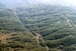 Baw Baw Plateau |
|
| |
|
| The low gradient of many of the streams on these surfaces has led to the accumulation of peaty soils formed from fen and bog vegetation. These materials are important reservoirs of sediment and fossil pollen that are proving of great significance in the study of Late Quaternary palaeo-environments in these areas. These peaty mossbed and fen communities are believed to play an important role in regulating runoff from these areas where precipitation is amongst the highest in the State. They are valuable components of the complex hydrological system that feeds the major northerly flowing streams that are vital to the health of the Murray River. | 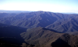 Mt Cobbler |
The most widespread soils are organic loams (Chernic Tenosols). They vary greatly in depth, and often overly remnants of an earlier soil mantle of more highly coloured material, often regolith material that still retains the fabric of the original bedrock. A distinctive stone-line is usually present between these two bodies of soil material. The highly weathered soil parent material is a poor source of plant nutrients so biological recycling of nutrients is thought to be important for the maintenance of the plant-nutrient capital in this environment. Nutrients in wind-transported dust may also be important. | |
Where there is permanent water in drainage-lines and ground-water discharge sites, wetland vegetation forms – fens of sedges and mossbeds (bogs) of Sphagnum moss occur. The anaerobic conditions produced by the permanent saturation of the material below these communities results in the accumulation of peat soils (Organosols). |
© State of Victoria (Agriculture Victoria) 1996 - .

This work, Victorian Resources Online, is licensed under a Creative Commons Attribution 4.0 licence. You are free to re-use the work under that licence, on the condition that you credit the State of Victoria (Agriculture Victoria) as author, indicate if changes were made and comply with the other licence terms.
The licence does not apply to ‘branding’ or some ‘images or photographs’ that may be owned by third parties. We ask you to seek prior approval to use images using the VRO feedback form. Access to higher quality images can also be provided on request.
This page was last updated on .