
Soil
| Back to Bet Bet Creek Catchment Homepage | Bet Bet Soil Index |
Earlier studies of Day (1985) and Schoknecht (1988) were carried out by the former Department of Conservation, Forests and Lands. These studies provide much of the basic soil and landform information available for these area. More recently, some soil pit sites have been undertaken by the former Department of Natural Resources and Environment. Additional work was undertaken by the former Department of Primary Industries part of a CRC for Plant-Based Management of Dryland Salinity (CRC-PBMDS) project and a North Central region land resource assessment project.
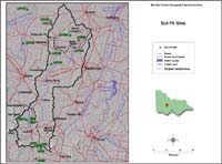 Bet Bet Creek Soil Pit Sites | Soil information provided here formed part of a former National Landcare Program (NLP) project during 1995-97. As part of this project a number of soil pits were characterised for selected Landcare Groups in the North Central region - including the Lexton and Natte Yallock and Timor West Landcare groups. Soil pits that were within (or just outside) the Bet Bet Creek Catchment have also been included. Soil pit information can be accessed by clicking onto sites marked on this map. |
| This area has a great diversity of soil types that reflect differences in parent material, topography, climate, organic activity and age (e.g. degree of weathering). Geology is a major determinant of soil types here. Soils developed on metamorphic hills Uniform textured soils that are shallow and stony occur on steep metamorphic ridges. These have high infiltration rates (in excess of 3 metres/day), indicating that this terrain should be regarded as having high recharge potential (Day 1985). | 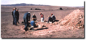 Soil Pit Field Day for Lexton Landcare Group (March 1995) |
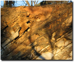 Dermosol on upper slopes of Ordovician rise. Note variation in soil depth to rock. | Soils developed on Ordovician sediments Shallow gradational textured soils typically occur on Ordovician hill crests (referred to as Dermosols using the Australian Soil Classification). Texture contrast soils with red clay subsoils are more common on gentle slopes. The subsoils of these texture contrast soils are typically sodic and the soils are referred to as Sodosols (using the Australian Soil Classification). |
Soils developed on granodiorite
Devonian granodiorite boulder outcrop is common on the upslope crests in the Dunluce area and soils are predominantly yellow/brown sands of uniform texture and variable depth (Day 1985). These are most likely classified as Tenosols (using the Australian Soil Classification). Permeability of these soils is high - although much of the infiltrating water travels laterally above the impermeable bedrock, emerging as seeps or springs on lower slopes (Day 1985).
A siliceous hardpan exists between 0.5 and 1.5 metres depth over much of the undulating granitic landscape, due probably to silica precipitation associated with groundwater fluctuations (Day 1985). Texture contrast soils, with red clay subsoils (that are often sodic) typically occur above the siliceous hardpan (where present) on gently undulating lower slopes. Surface horizons are sandy loam to light sandy clay loam in texture and highly permeable - overlying a relatively thin red clay subsoil horizon (20-50 cm deep) that is much less permeable and which restricts deep percolation of water. These soils are classified as Sodosols (using the Australian Soil Classification). Soil Pit Site LP111 is an example of a Red Sodosol developed on granite just north of Dunluce.
| Soils developed on basalt Soils commonly with associated gilgai microrelief occur in basalt areas in much of the area. These soils are typically Grey Vertosols (using the Australian Soil Classification) that are often calcareous at depth. These soils are clayey throughout and display significant shrinking and swelling during wetting cycles and are characterised by significant profile cracking when dry (usually with large cracks up to the soil surface). Soil Pit Site LP115 is an example of a Grey Vertosol near Wareek. In some depression areas associated with the gilgai microrelief, the soils will more typically have a clay loam surface horizon overlying medium to heavy clays. The surface will be hardsetting and less prone to open cracking and the subsoil may also be browner in colour. Soil Pit Site 114a is an example of a Brown Sodosol between Bung Bong and Wareek - developed on the depression of a gilgai. Overall these soils have very low permeabilities and consequently a low recharge rating. | 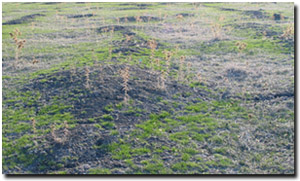 Gilgai microrelief near Wareek |
Soils developed on colluvium
Gentle colluvial slopes associated with granodiorite and Ordovician sediments generally support texture contrast soils and have low recharge potential (Day 1985).
Extensive colluvial slopes above the alluvial plains have formed in the Timor West to Dunluce area - through coalescence of broad outwash fans skirting the Black Ranges and Mt Hooghly (particularly on the southern and eastern flanks of these hills). Soils formed on the upper slopes have gradational texture profiles and are usually stony. Texture contrast soils more commonly occur on lower slopes and are less permeable than soils on the upper slopes. Soil Pit Site LP108 is an example of a Red Sodosol that occurs on the footslopes of Mt Hooghly.
The soils of the western and southern slopes of the Black Ranges have a light textured sandy surface horizon.
Soils developed on older alluvium
These soils have developed on Quaternary sediments (clays, silt, sand and gravel distributed on plains traversed by leveed streams). The source of sediment is a major determinant of many of the soil properties. For example, sandy clays have developed on alluvial plains adjacent to granitic country, whilst shrinking-swelling clays are derived from basaltic sources.
Soils on alluvial plains associated with Ordovician terrain are usually texture contrast soils with fine sandy clay loam surface horizons (often with a bleached subsurface horizon) overlying medium to heavy clay red or brown subsoils that are usually sodic to strongly sodic. The subsoils are often calcareous due to accession of windblown carbonates. Soil Pit Site LP110 is an example of a Brown Sodosol located just south of Timor West. Soil Pit Site LP109 is an example of a Red Sodosol just north of Timor West.
References
Day, C. (1985). A Study of the Geomorphic, Soil and Geohydrological Conditions of the Timor West/Black Ranges Areas. Department of Conservation. Forests and Lands
Schoknecht, N. (1988). Land Inventory of the Loddon River Catchment - a reconnaissance survey. Department of Conservation, Forests and Lands.
© State of Victoria (Agriculture Victoria) 1996 - 2025.

This work, Victorian Resources Online, is licensed under a Creative Commons Attribution 4.0 licence. You are free to re-use the work under that licence, on the condition that you credit the State of Victoria (Agriculture Victoria) as author, indicate if changes were made and comply with the other licence terms.
The licence does not apply to ‘branding’ or some ‘images or photographs’ that may be owned by third parties. We ask you to seek prior approval to use images using the VRO feedback form. Access to higher quality images can also be provided on request.
This page was last updated on 23/03/2020.