
Vertosols
|
| Vertosols, or cracking clay soils, occur in four situations - on floodplains, ridged plains, volcanic plains and palaeolacustrine plains. Large floodplains on which grey Vertosols predominate occur beside the Murray, Loddon and Wimmera Rivers, whilst other streams have smaller occurrences. Salinity status is generally low. However, poor surface structure usually limits agricultural use to grazing. The ridged plain of the Wimmera is dominated by Grey Vertosols with self-mulching surfaces and alkaline sodic subsoils. The land is heavily cropped. Other soils include red, brown and grey Sodosols. |
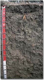
Volcanic plains in the upland tract of the Loddon and Campaspe Rivers have grey and black Vertosols which are gilgaied. Yellow Sodosols may occupy gilgai depressions, and scarps generally support red Dermosols.
| This map of Vertosols in the North Central region has been developed by Jim Rowan and is based mainly on the Land Systems of Victoria (1:250 000) with some use of the Atlas of Australian Soils (Northcote 1962). It shows areas where Vertosols are most likely to occur within the region. Note that other soil types may also occur within these mapped areas (although they are likely to be a more minor component). | 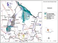 Vertosols North Central Region |
Palaeolacustrine plains occupy a broad wedge extending from Lake Tyrrell for some 30 km northwards, developed on early Pleistocene clays that have been weathered and affected by wind and water erosion. Gilgaied grey clays predominate but there are scattered east-west dunes with sandy Calcarosols. Agricultural productivity is limited by the combination of dry climate and heavy soils.
© State of Victoria (Agriculture Victoria) 1996 - 2025.

This work, Victorian Resources Online, is licensed under a Creative Commons Attribution 4.0 licence. You are free to re-use the work under that licence, on the condition that you credit the State of Victoria (Agriculture Victoria) as author, indicate if changes were made and comply with the other licence terms.
The licence does not apply to ‘branding’ or some ‘images or photographs’ that may be owned by third parties. We ask you to seek prior approval to use images using the VRO feedback form. Access to higher quality images can also be provided on request.
This page was last updated on 23/03/2020.