
Soil/Landform Unit - Howard Creek plains
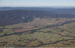 Upper catchment for Howard Creek. Note the abundant vineyards occupying the footslopes of the Pyrenees Ranges |
0.28% of CMA region Alluvial and colluvial plains that supply significant surface and subsurface volumes to the Wimmera River include the Howard Creek plains in the south-east of the Wimmera CMA region. Part of the Dissected Western Uplands, the plains include a suite of colluvial footslopes and alluvial floodplains of mainly sodic (Sodosols) and non-sodic yellow texture contrast soils (Chromosols). These soils can be extremely prone to gully and tunnel erosion where subsoils are exposed. Soil surfaces can be hardsetting and vulnerable to sheet and rill erosion where insufficient ground coverage exists. Land use has changed largely with viticulture now well established up the Howard Creek valley on colluvial footslopes while grazing and cereal cropping also exist. Woodlands are the dominant native vegetation community present, including Creekline Grassy Woodland, Grassy Woodland and Plains Woodland. Grassy Woodland/Alluvial Terraces Herb-rich Woodland Mosaic has also been recorded. | 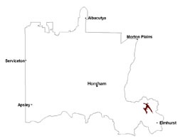 |
 View over Howard Creek as it passes through Landsborough | 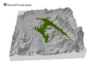 |
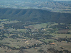
 |  Plains east of Joel South with slight undulations |
Component | 1 | 2 | 3 | 4 |
Proportion of soil-landform unit | 5% | 30% | 55% | 10% |
| CLIMATE Rainfall (mm) | Annual: 580 | |||
| Temperature (oC) | Minimum 8, Maximum 20 | |||
| Precipitation less than potential evapotranspiration | October–April | |||
| GEOLOGY Age and lithology | Quaternary silt, sand and minor gravel (Shepparton Formation); Neogene gravel, sand and silt; Quaternary fluvial gravel, sand and silt; Cambrian marine sandstone, siltstone and biotite schist (St Arnaud Group) | |||
| Geomorphology | ||||
| LANDUSE | Uncleared areas: water supply; nature conservation Cleared areas: dryland cropping; sheep grazing; viticulture; residential development; water supply | |||
| TOPOGRAPHY Landscape | Undulating and dissected plains | |||
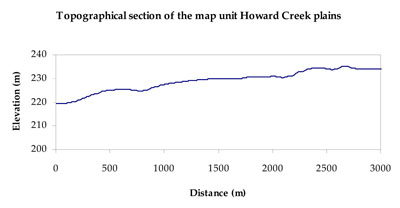
| Elevation range (m) | 205–326 | |||
| Local relief (m) | 3–5 | |||
| Drainage pattern | Dendritic | |||
| Drainage density (km/km2) | 1.4 | |||
| Landform | Long broad footslopes (Howard Creek 2 & 3) | Alluvial floodplains (Howard Creek 1) | ||
| Landform element | Moderate footslope | Gentle footslope | Alluvial flat | Drainage line |
| Slope and range (%) | 5 (3-10) | 2 (1-3) | 0 (0-1) | 0 (0-1) |
| Slope shape | Concave | Linear | Straight | Concave |
| NATIVE VEGETATION Ecological Vegetation Class | Grassy Woodland/Alluvial Terraces Herb-rich Woodland Mosaic (38.0%), Creekline Grassy Woodland (23.7%), Plains Woodland (22.6%), Other (7.9%) | |||
| SOIL Parent material | Colluvial and alluvial gravel, sand and silt | Colluvial and alluvial gravel, sand and silt | Alluvial gravel, sand and silt | Alluvial gravel, sand and silt |
| Description (Corangamite Soil Group) | Sodic and . -sodic, yellow and brown texture contrast soils (5) | Sodic and non-sodic, yellow and brown texture contrast soils (5) | Sodic brown, yellow and grey texture contrast soils (12) | |
| Soil type sites | ||||
| Surface texture | Sandy clay loam | Sandy clay loam | Sandy loam | Loam, fine sandy (heavy) |
| Permeability | Moderate | Moderate | Moderate | Moderate |
| Depth (m) | > 2 | > 2 | > 2 | > 2 |
| LAND CHARACTERISTICS, POTENTIAL AND LIMITATIONS Critical land features, processes, forms | Hardsetting and soft surfaces susceptible to sheet and rill erosion even on gentle slope due to impeding layer (clay or hardpan). Subsurface soil and upper subsoil susceptible to compaction, and also gully erosion where sodic and deep. Topsoil may be susceptible to acidification. | Hardsetting and soft surfaces susceptible to sheet and rill erosion even on gentle slope due to impeding layer (clay or hardpan). Subsurface soil and upper subsoil susceptible to compaction, and also gully erosion where sodic and deep. Topsoil may be susceptible to acidification. | Lighter surface susceptible to sheet and rill erosion and compaction, especially with low organic matter. Subsoil susceptible to rill and gully erosion where sodic, deeper and sloping terrain. Lighter variants are well drained. | Lighter surface susceptible to sheet and rill erosion and compaction, especially with low organic matter. Subsoil susceptible to rill and gully erosion where sodic, deeper and sloping terrain. Lighter variants are well drained. Upper soil susceptible to acidification. |
© State of Victoria (Agriculture Victoria) 1996 - .

This work, Victorian Resources Online, is licensed under a Creative Commons Attribution 4.0 licence. You are free to re-use the work under that licence, on the condition that you credit the State of Victoria (Agriculture Victoria) as author, indicate if changes were made and comply with the other licence terms.
The licence does not apply to ‘branding’ or some ‘images or photographs’ that may be owned by third parties. We ask you to seek prior approval to use images using the VRO feedback form. Access to higher quality images can also be provided on request.
This page was last updated on .