
SW25
|
| SW25 | 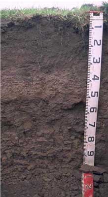 Ferric (& Sodic), Eutrophic, Brown CHROMOSOL | |
| Camperdown | |||
| Undulating basalt hills | |||
| Quaternary–Newer volcanics (scoria) | |||
| Valley floor | |||
Horizon | Depth (cm) | Description | ||
A11 | 0-10 | Very dark brown (10YR2/2); very fine sandy clay loam; weak coarse blocky, parting to moderate medium polyhedral structure; very firm consistence (dry); pH 5.3; gradual boundary to: | ||
A12 | 10-30 | Very dark greyish brown (10YR3/2); very fine sandy clay loam; moderate medium polyhedral, parting to moderate to strong fine polyhedral structure; pH 5.3; firm consistence (moist); clear boundary to: | ||
A2 | 30-50 | Dark brown (10YR4/3); conspicuously bleached; gravelly clay loam; contains many (50%) medium size (2-10 mm) ferruginous nodules; pH 6.2; abrupt boundary to: | ||
B21 | 50-60 | Dark brown (7.5YR4/4); medium clay; moderate coarse polyhedral, parting to strong medium polyhedral structure; strong consistence (dry); pH 6.7: | ||
B22 | 60-80 | Dark brown (10YR4/3); medium heavy clay; strong coarse prismatic, parting to medium prismatic parting to moderate coarse blocky structure; strong consistence dry; pH 7.0: | ||
B23 | 80+ | Dark brown (7.5YR4/2) with yellowish brown (10YR5/8) mottles; medium clay; strong coarse prismatic, parting to medium prismatic parting to moderate coarse to medium blocky structure; pH 7.2. | ||
| Management considerations | ||||
| Strong texture contrast between the surface soil and the subsoil is a very important soil feature. This can have a major effect by reducing and/or redirecting the internal drainage and restricting root growth beyond the upper horizons. Options include reduced tillage, improving organic matter content and altering the subsoil through artificial drainage (ripping, mole drainage) and/or chemical amelioration (gypsum) to improve structure. Ferruginous and Ferromanganiferous nodules, concretions and pans can restrict root penetration and limit available water holding capacity where there are sufficient amounts, often forming a discontinuous or continuous pan where concentrated (>50%). They are also an indication of a periodic waterlogging. Either shallow rooted species can be planted to avoid the nodules, subsoil drainage may need to be considered, possibly in conjunction with deeper rooted plants which could puncture the nodule layer and access available water and nutrients stored below. | ||||
Analytical data
Site SW25 | Sample depth | pH | EC | NaCl | Ex Ca | Ex Mg | Ex K | Ex Na | Ex Al | Ex acidity | FC (-10kPa) | PWP (-150kPa) | KS | FS | Z | C | |
Horizon | cm | H2O | CaCl2 | dS/m | % | cmolc/kg | cmolc/kg | cmolc/kg | cmolc/kg | mg/kg | cmolc/kg | % | % | % | % | % | % |
A11 | 0-10 | 5.3 | 4.7 | 0.31 | 0.02 | 7.9 | 1.6 | 1.2 | 0.1 | N/R | N/R | 38.6 | 16 | 9 | 34 | 21 | 22 |
A12 | 10-30 | 5.3 | 4.6 | 0.11 | N/R | 6.7 | 2 | 0.4 | 0.1 | N/R | N/R | 34 | 12.2 | 9 | 37 | 23 | 23 |
A2 | 30-50 | 6.2 | 5.3 | 0.07 | N/R | 5.1 | 2.6 | 0.3 | 0.2 | N/R | N/R | 27.9 | 11.2 | 23 | 34 | 17 | 22 |
B21 | 50-60 | 6.7 | 5.8 | 0.11 | N/R | 6.2 | 8.4 | 0.2 | 0.8 | N/R | N/R | 43.8 | 28.1 | 6 | 16 | 8 | 64 |
B22 | 60-80 | 7 | 6.1 | 0.14 | N/R | 5.9 | 11 | 0.3 | 2 | N/R | N/R | 51 | 32 | 3 | 12 | 11 | 71 |
B23 | 80+ | 7.2 | 6.2 | 0.16 | N/R | 6.6 | 15 | 0.3 | 3.2 | N/R | N/R | 53 | 30.6 | 5 | 20 | 16 | 56 |
© State of Victoria (Agriculture Victoria) 1996 - .

This work, Victorian Resources Online, is licensed under a Creative Commons Attribution 4.0 licence. You are free to re-use the work under that licence, on the condition that you credit the State of Victoria (Agriculture Victoria) as author, indicate if changes were made and comply with the other licence terms.
The licence does not apply to ‘branding’ or some ‘images or photographs’ that may be owned by third parties. We ask you to seek prior approval to use images using the VRO feedback form. Access to higher quality images can also be provided on request.
This page was last updated on .