
SW48
|
| SW48 | 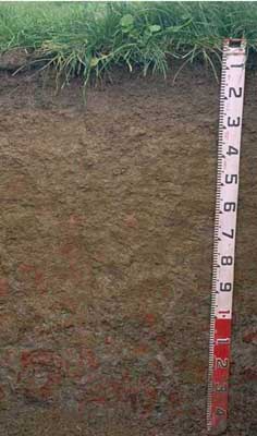 Bleached-Vertic (& Ferric), Eutrophic, Brown Chromosol | |
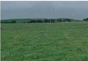
| Wangoom | |||
| Gently undulating rise | |||
| Quaternary-Newer volcanics (basalt) | |||
| Lower slope | |||
Horizon | Depth (cm) | Description | ||
A1 | 0–5 | Very dark brown (10YR2/2); fine sandy clay loam; contains many (40%) ferruginous nodules (2-5 mm in size); pH 5.7; clear change to: | ||
A2 | 5–25 | Brown (10YR5/3), conspicuously bleached; gravely sandy loam; contains very many (80%) ferruginous nodules (2–15 mm in size); pH 6.4; sharp change to: | ||
B21 | 25–50 | Dark yellowish brown (10YR4/4) with yellowish brown (10YR5/6) and some red (2.5YR5/8) mottles; medium clay; strong coarse polyhedral, parting to strong medium polyhedral and strong lenticular structure; weak to firm consistence (moist); pH 6.6; gradual change to: | ||
B22 | 50–70 | Yellowish brown (10YR5/4) with yellowish brown (10YR5/6) and red (2.5YR5/8) mottles common; medium clay; strong coarse polyhedral, parting to strong medium polyhedral and medium to fine lenticular structure; pH 6.3; gradual change to: | ||
B23 | 70–105 | Light brownish grey (10YR6/2) with many yellowish brown (10YR5/8) and red (2.5YR5/8) mottles; medium clay; strong coarse polyhedral, parting to strong medium polyhedral and medium to fine lenticular structure; pH 5.8; gradual change to: | ||
B24 | 105+ | Light grey (N6) with red (2.5YR5/8) and common strong brown (7.5YR5/6) mottles; light clay; strong coarse polyhedral, parting to strong fine polyhedral and medium to fine lenticular structure; weathered volcanic material present; pH 5.3. | ||
| Management considerations | ||||
| The following comments are made on the basis of examination of a single profile and are therefore indicative only. Fertiliser and lime requirements would need to be verified and quantified through analysis of bulk samples of standard depth taken from across a whole paddock. The upper soil profile is mainly slightly acid which should not present limitations to most plants. The deeper subsoil does become strongly acid which indicates that aluminium and manganese toxicity may occur at depth. Lime can be used to increase soil pH but is not likely to be practical when the deeper subsoil is strongly acid. Other factors need to be considered before lime is recommended (e.g. pasture species grown, method of application, local trial responses, soil surface structure and likely cost/benefit). Manganese toxicity is more likely to occur in poorer drained situations (as waterlogging may bring manganese into solution). If lime is required, and pH increased, then the availability of major nutrients (e.g. phosphorus and some trace elements such as molybdenum) may improve. The strong texture contrast between the surface soil and the coarser structured subsoil is a very important soil feature. This can have a major effect by reducing and/or redirecting the internal drainage and restricting root growth beyond the upper horizons. Bleached A2 horizons (or subsurface soils) are a major feature of many of soils within the Corangamite region. These layers are usually an indication of restricted drainage, and they are poorly structured (often massive) and have low organic matter levels, nutrient and water holding capacities. They are often associated with a restrictive soil below - such as a denser clayey subsoil. These bleached horizons may act as conduit for subsurface flow, particularly on sloping ground. Mottled subsoils are common and are also an indication of periodic waterlogging, particularly if the mottles are pale (low oxygen conditions). Improved drainage may be beneficial. Ferruginous and Ferromanganiferous nodules, and concretions (‘buckshot’) can restrict root penetration and limit available water holding capacity - forming a discontinuous or continuous pan where concentrated (>50%). Buckshot layers are also an indication of periodic waterlogging. Subsurface drainage may need to be considered where topsoils are shallow. The subsoil is vertic, which indicates that significant shrinking and swelling occurs during wetting and drying cycles. This may disturb the roots of some plant species and has engineering implications (e.g. disturbance to fencelines and building foundations). The subsoil is reasonably well structured and non-sodic – so although it is likely to restrict water movement due to it’s significantly higher clay content – it is likely to be more suitable for root and water movement than more coarsely structured and sodic subsoils in the region. Mole drains may work reasonably well in these soils. | ||||
Analytical data
Site SW48 | Sample depth | pH | EC | NaCl | Ex Ca | Ex Mg | Ex K | Ex Na | Ex Al | Ex acidity | FC (-10kPa) | PWP (-150kPa) | KS | FS | Z | C | |
Horizon | cm | H2O | CaCl2 | dS/m | % | cmolc/kg | cmolc/kg | cmolc/kg | cmolc/kg | mg/kg | cmolc/kg | % | % | % | % | % | % |
A1 | 0-5 | 5.7 | 4.9 | 0.22 | N/R | 7 | 2 | 1 | 0.1 | N/R | N/R | 38.3 | 17.1 | 19 | 26 | 21 | 19 |
A2 | 5-25 | 6.4 | 5.5 | 0.07 | N/R | 2.7 | 1 | 0.4 | 0.05 | N/R | N/R | 21.2 | 8 | 40 | 25 | 18 | 14 |
B21 | 25-50 | 6.6 | 6.1 | 0.19 | N/R | 5.5 | 7.9 | 0.2 | 0.6 | N/R | N/R | 51.5 | 34.7 | 2 | 4 | 6 | 83 |
B22 | 50-70 | 6.3 | 6 | 0.23 | N/R | 3.4 | 8.7 | 0.1 | 0.6 | N/R | N/R | 53 | 36.5 | 1 | 3 | 7 | 88 |
B23 | 75-105 | 5.8 | 5.4 | 0.21 | N/R | 2.2 | 8.2 | 0.1 | 0.8 | N/R | N/R | 50.5 | 33.9 | 2 | 6 | 7 | 82 |
B24 | 105+ | 5.3 | 4.8 | 0.19 | N/R | 1.1 | 5.7 | <0.1 | 0.8 | N/R | N/R | 46.9 | 30.9 | 8 | 16 | 13 | 63 |
© State of Victoria (Agriculture Victoria) 1996 - .

This work, Victorian Resources Online, is licensed under a Creative Commons Attribution 4.0 licence. You are free to re-use the work under that licence, on the condition that you credit the State of Victoria (Agriculture Victoria) as author, indicate if changes were made and comply with the other licence terms.
The licence does not apply to ‘branding’ or some ‘images or photographs’ that may be owned by third parties. We ask you to seek prior approval to use images using the VRO feedback form. Access to higher quality images can also be provided on request.
This page was last updated on .