
SFS5
|
| SFS5 | 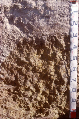 Left: Hypernatric, Grey SODOSOL | |
| Brewster, Trawalla East Road (West of Ballarat) | |||
| Undulating plain | |||
| Quaternary volcanic, basalt. | |||
| Simple slope | |||
| 2–5% | |||
| North | |||
Horizon | Depth (cm) | Description (‘hollow’ of gilgai) = left half of profile image | ||
Ap | 0–20 | Brown (10YR4/3 moist) to pale brown (10YR6/3 dry), fine sandy loam to loam, weak to very firm consistence (depending on colour – lighter = stronger); Highly variable and mixed material. Ap originally likely to be less than 10 cm and is now dominated by apedal, A2 material. pH 5.5; clear boundary to: | ||
A2 | 20–20/90 | Light brownish grey(10YR6/2 moist) to white (10YR8/2 dry); fine sandy loam or gravelly loam; pockets of medium to very coarse (5–30 mm) buckshot gravel comprises up to 80% of this horizon in places and can form a layer 100–400 mm thick (at some sites this is cemented into a pisolitic mass), <10% is magnetic; pH 6.1; clear, irregular boundary to: | ||
B21gt | 20/90+ | Mottled dark grey (10YR4/1 moist) (50%) and yellowish brown (10YR5/6 moist), with fine dark red (2.5YR4/8) mottles becoming weak red (2.5YR5/4) at depth; medium clay; fine (<5 mm) smooth-faced polyhedral structure; pH 7.0. | ||
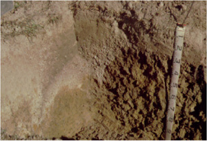
Horizon | Depth (cm) | Description (‘hollow’ of gilgai) = left half of profile image | ||
Ap | 0–20 | AS FOR HOLLOW (above) | ||
B21tg | 20–70 | Mottled light olive brown (2.5Y5/4) and olive yellow (2.5Y6/6); medium clay; irregular medium to coarse (40–80 mm) prismatic parting to medium to coarse (15–40 mm) angular blocky or polyhedral structure; roots between peds contrasts with lack of roots at this depth in the ‘hollow’ component of the gilgai; clear boundary to: | ||
B22gss | 70+ | Olive brown (2.5Y4/4 moist) with many (20-50%) light olive brown (10YR5/6) mottles; medium heavy clay; frequent small slickensides; less well developed structure than B21. | ||
| Management considerations | ||||
| Described by the owner as ‘crabhole country’, this slightly elevated, gently sloping land has well developed ‘gilgai’ features in the subsoil. The very variable nature of this soil is evident in material in the beds which have white A2 horizon material, buckshot, pisolitic cemented buckshot and subsoil clay all present at the ground surface. ‘Spew’ or ‘hollow units’ are elongated downslope (~10 m). ‘Puffs’ are of smaller lateral dimensions than the ‘hollows’ being 1–3 metres across. In the excavated pit, two faces were picked back. SFS5a to show deep A2 with buckshot and SFS5b to show puff unit (shallow depth to clay). This soil presents real problems to the agriculturalist. Water holding properties are extremely different in the ‘puff’ compared with the hollow and this is often evident in the crop. The topsoil is not well structured, disintegrates to a ‘flour’ when dry-tilled, is weak and ‘spewy’ when wet and hard set when dry. Protection of the surface with ground cover is essential to reduce the slaking and sealing effects of rain. Under high rainfall / runoff conditions this soil is potentially highly erodible. The subsoil is sodic and has a high clay content so this soil is also prone to severe waterlogging. The slope of the land and the forming of beds should alleviate this in the surface horizons but erosion is a potential hazard should the furrows carry excessive runoff. | ||||
Analytical data
Site SFS5a 'Hollow' | Sample depth | pH | EC | NaCl | Ex Ca | Ex Mg | Ex K | Ex Na | Ex Al | Ex acidity | FC (-10kPa) | PWP (-150kPa) | KS | FS | Z | C | |
Horizon | cm | H2O | CaCl2 | dS/m | % | cmolc/kg | cmolc/kg | cmolc/kg | cmolc/kg | mg/kg | cmolc/kg | % | % | % | % | % | % |
Ap | 0–10 | 5.5 | 5.1 | 0.31 | 0.02 | 4.1 | 0.8 | 0.6 | <0.1 | <10 | 1.0 | 33.0 | 9.1 | 4.1 | 37.7 | 27.5 | 20 |
A2 | 30–50 | 6.1 | 5.4 | 0.07 | N/R | 0.86 | 0.57 | 0.15 | 0.19 | <10 | 1.4 | 22.0 | 3.1 | 2.2 | 48.8 | 37.5 | 10.5 |
B21gt | 80–100 | 7.0 | 6.0 | 0.21 | N/R | 5.8 | 12.0 | 0.66 | 3.9 | N/R | 11 | 53.6 | 30.8 | 1.0 | 8.0 | 5.5 | 80.5 |
Site SFS5a 'Puff' | Sample depth | pH | EC | NaCl | Ex Ca | Ex Mg | Ex K | Ex Na | Ex Al | Ex acidity | FC (-10kPa) | PWP (-150kPa) | KS | FS | Z | C | |
Horizon | cm | H2O | CaCl2 | dS/m | % | cmolc/kg | cmolc/kg | cmolc/kg | cmolc/kg | mg/kg | cmolc/kg | % | % | % | % | % | % |
Ap | 0–20 | 5.5 | 5.1 | 0.31 | 0.02 | 4.1 | 0.8 | 0.6 | <0.1 | <10 | 1.0 | 33.0 | 9.1 | 4.1 | 37.7 | 27.5 | 20.0 |
B21tg | 25–50 | 6.5 | 5.7 | 0.21 | N/R | 6.7 | 12.0 | 1.5 | 1.6 | N/R | 11.0 | 51.2 | 28.7 | 0.8 | 10.1 | 7.5 | 78.0 |
B22gss | 80–100 | 7.5 | 6.6 | 0.30 | 0.03 | 5.1 | 9.7 | 0.7 | 2.4 | N/R | N/R | 55.3 | 31.1 | 1.1 | 6.2 | 4.5 | 80.0 |
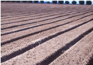
Raised beds formed in the paddock at Brewster.
Note the slight undulations in the line of the beds and the pockets of paler (A2)
material that have been brought to the surface.
© State of Victoria (Agriculture Victoria) 1996 - .

This work, Victorian Resources Online, is licensed under a Creative Commons Attribution 4.0 licence. You are free to re-use the work under that licence, on the condition that you credit the State of Victoria (Agriculture Victoria) as author, indicate if changes were made and comply with the other licence terms.
The licence does not apply to ‘branding’ or some ‘images or photographs’ that may be owned by third parties. We ask you to seek prior approval to use images using the VRO feedback form. Access to higher quality images can also be provided on request.
This page was last updated on .