
Soil/Landform Unit 52
Landform Unit Description
Page top
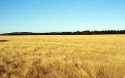 This gentle plain east of Yendon are mainly used for grazing and cropping. There is some recent residential development near this site |
0.12% of CMA region The gently undulating basalt plains in the Navigators-Yendon area form part of a sequence of volcanic landforms within the Western Plains. These plains are characterised by gently undulating slopes that have steep short slopes on their eastern margin. The vegetation classes include Plains Grassy Woodland, Grassy Woodland, Valley Grassy Forest and Swampy Riparian Woodland with the dominant species being manna gum (E. viminalis), swamp gum (E ovata), messmate stringybark (E. obliqua) and Candlebark (E. rubida). The area consists of a variety of texture contrast soils. The colour of the surface soil on the upper slopes tends to be browner than the grey lower slopes. There are minor occurrences of friable red gradational soils. Land use is mainly grazing for beef cattle and sheep, and cereal cropping. Residential development around Yendon is a minor land use. Soil compaction is a problem on the lower slopes and depressions where minor gully erosion and waterlogging also occur on these texture contrast soils. | 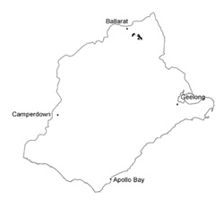 |
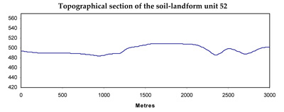
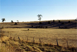 The flat represents an alluvial plain between the resistant basalt flow and the neighbouring granite | 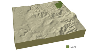 |
|
Component | 1 | 2 | 3 | 4 | 5 | 6 |
Proportion of soil-landform unit | 60% | 2% | 2% | 8% | 1% | 27% |
| CLIMATE Rainfall (mm) | Annual: 880 | |||||
| Temperature (oC) | Minimum 6, Maximum 17 | |||||
| Precipitation less than potential evapotranspiration | November-March | |||||
| GEOLOGY Age and lithology | ||||||
| Geomorphology | ||||||
| LANDUSE | Uncleared: Nature conservation Cleared: Beef cattle and sheep grazing; cropping | |||||
| TOPOGRAPHY Landscape | Gently undulating plains | |||||
| Elevation range (m) | 466-570 | |||||
| Local relief (m) | 2 | |||||
| Drainage pattern | Dendritic | |||||
| Drainage density (km/km2) | 2.2 | |||||
| Landform | Depressions | Undulating plain | Terrace | |||
| Landform element | Long gentle upper slopes | Depressions | Stony rises | Gentle slopes | Depressions | |
| Slope and range (%) | 2 (1-3) | 1 (1-2) | 3 (2-5) | 4 (1-6) | 1 (1-2) | 1 (1-2) |
| Slope shape | Straight | Straight | Convex | Convex | Straight | Straight |
| NATIVE VEGETATION Ecological Vegetation Class | Plains Grassy Woodland (5.2%), Grassy Woodland (0.9%), Valley Grassy Forest (0.3%), Swampy Riparian Woodland (0.2%) | |||||
| Dominant species | E. ovata, E. viminalis, E. rubida, E. obliqua | E. ovata, E. viminalis, E. rubida, E. obliqua | E. ovata, E. viminalis, E. rubida, E. obliqua | E. viminalis, E. radiata, E. obliqua | E. viminalis, E. radiata, E. obliqua | E. viminalis, E. radiata |
| SOIL Parent material | In situ weathered basalt | Alluvium | In situ weathered basalt | In situ weathered basalt | In situ weathered basalt | Unconsolidated gravel, sand, silty and clay |
| Description (Corangamite Soil Group) | Black clay soil, coarse structure (31) | Red shallow, stony gradational soil (40) | Red gradational soil, fine structure (40) | Mottled brown, grey or yellow texture contrast soil, coarse structure (37) | Dark brown soil (variable) (34) | |
| Soil type sites | ||||||
| Surface texture | Clay loam | Clay | Clay loam | Clay loam | Clay loam | Fine sandy clay loam |
| Permeability | Moderate to low | Moderate | High | High | Moderate to low | Moderate to low |
| Depth (m) | 1.5 | 1.5 | 0.5 | 2 | 1.5 | 2 |
| LAND CHARACTERISTICS, POTENTIAL AND LIMITATIONS | Hardsetting surfaces and slowly permeable subsoils often result in overland flow and periodic waterlogging. Soil compaction and sheet erosion also occur. | Clay soils beside creeks are prone to waterlogging. Streambank undercutting and streambank erosion occur where streambanks are exposed without adequate ground coverage. | Overland flow, sheet erosion and nutrient decline are very minor. These soils have a high agricultural versatility but are limited by surface stones. | Hardsetting surfaces and slowly permeable subsoils often result in overland flow and periodic waterlogging. Soil compaction and sheet erosion also occur. | Hardsetting surfaces and slowly permeable subosils often result in overland flow and periodic waterlogging. Soil compaction and sheet erosion also occur. | Low-lying areas receiving drainage are prone to waterlogging and overland flow. Streambank erosion and gully erosion occur where soils are exposed without adequate ground coverage. |
© State of Victoria (Agriculture Victoria) 1996 - .

This work, Victorian Resources Online, is licensed under a Creative Commons Attribution 4.0 licence. You are free to re-use the work under that licence, on the condition that you credit the State of Victoria (Agriculture Victoria) as author, indicate if changes were made and comply with the other licence terms.
The licence does not apply to ‘branding’ or some ‘images or photographs’ that may be owned by third parties. We ask you to seek prior approval to use images using the VRO feedback form. Access to higher quality images can also be provided on request.
This page was last updated on .