
SFS19
|
| SFS19 | 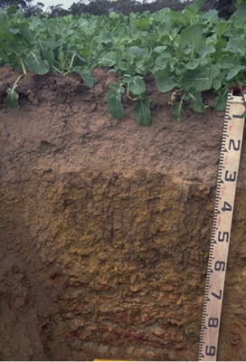 Vertic (& Ferric), Mottled-Subnatric, Brown SODOSOL | |
| Teesdale-Inverleigh Road | |||
| Level plain | |||
| Neogene Moorabool Viaduct Formation | |||
| Plain | |||
| 0-1% | |||
| 0 | |||
Horizon | Depth (cm) | Description | ||
Ap | 0–10 | Dark brown (10YR3/3); sandy loam (-); weakly pedal structure tending to platy at bottom of Ap; consistency weak; clear boundary to: | ||
A2c | 10–30 | Yellowish brown (10YR5/4 moist) to pale brown (10YR6/3 dry); gravelly loam; apedal structure, weak consistence; very many (>50%) medium to coarse (5-20 mm) irregular sub-rounded gravel—mostly cemented ferruginous remnants of Moorabool Viaduct sand but also minor component of rounded quartz alluvial gravel; sharp smooth boundary to: | ||
B21t | 30–60/70 | Brown (10YR5/3) clay ped exteriors (thick cutans) surrounding brownish yellow (10YR6/8) matrix with reddish yellow (7.5YR6/8) mottles; medium clay; coarse (<60 mm) prismatic peds parting to medium to coarse (10–40 mm) blocky and fine to medium (<15 mm) polyhedral and lenticular structure; strong consistence; slickensided appearance to most of the ped fractures; clear boundary to: | ||
B/C | 60/70+ | Mottled dark red (10R3/6) to red (10R5/8) with reddish yellow (7.5YR6/8) and grey (2.5Y7/1) coarse mottling; weathered ferruginised Moorabool Viaduct Formation sediments with clay accumulation; rigid ferruginised masses of material sandier than B21 above but with reticulate structure defined by thick bands of illuviated clay. | ||
| Management considerations | ||||
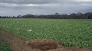
| The three profiles shown here represent well the variation over short distances (within farm or paddock) for soils developed on the Moorabool Viaduct formation sediments. The texture contrast and the sodic subsoil restricts drainage and the soils readily become waterlogged in winter. The sandy topsoils are very susceptible to soil structure decline; the weak aggregation is readily destroyed by cultivation and the soils are prone to compaction. Bare soil is vulnerable to structural breakdown by rain (slaking and sealing) and to erosion by water. In dry conditions these soils are known to be vulnerable to wind erosion. Plough pans are common in these soils. Disruption of pans by tillage is short lived unless controlled traffic is deployed in cropping situations. Raised beds have been used with some degree of success in these soils but the unstable topsoils do not lend themselves well to bed survival. | ||||
Analytical data
Site SFS19 | Sample depth | pH | EC | NaCl | Ex Ca | Ex Mg | Ex K | Ex Na | Ex Al | Ex acidity | FC (-10kPa) | PWP (-150kPa) | KS | FS | Z | C | |
Horizon | cm | H2O | CaCl2 | dS/m | % | cmolc/kg | cmolc/kg | cmolc/kg | cmolc/kg | mg/kg | cmolc/kg | % | % | % | % | % | % |
Ap | 0-10 | 6.3 | 6.1 | 0.22 | N/R | 3.3 | 0.7 | 0.5 | <0.1 | <10 | 6.9 | 10.4 | 6.4 | 60.4 | 23.8 | 3.0 | 7.5 |
B21 | 15-30 | 5.1 | 4.5 | 0.05 | N/R | 0.88 | 0.25 | 0.24 | 0.24 | 18 | 3.7 | 7.0 | 2.6 | 58.7 | 28.5 | 4.0 | 6.0 |
B22 | 40-60 | 6.7 | 6.2 | 0.15 | N/R | 5.4 | 7.9 | 1.4 | 1.4 | <10 | 8.8 | 50.4 | 30.3 | 6.4 | 2.6 | 2.5 | 86.0 |
B/C | 80+ | 7.6 | 6.8 | 0.12 | N/R | 2.8 | 5.7 | 0.45 | 0.45 | N/R | N/R | 30.2 | 19.9 | 23.4 | 10.2 | 6.0 | 58.5 |
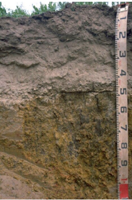 Variant with less gravel, thicker and sandier A1+A2 horizon. More prone to wind erosion and waterlogging | 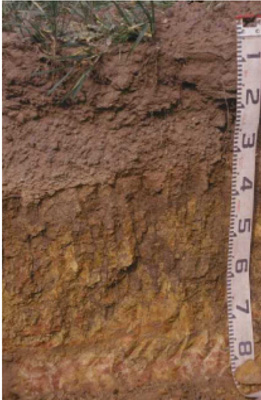 Variant with shallower profile and greater (80%) and coarser (10-40 mm) gravel content |
© State of Victoria (Agriculture Victoria) 1996 - .

This work, Victorian Resources Online, is licensed under a Creative Commons Attribution 4.0 licence. You are free to re-use the work under that licence, on the condition that you credit the State of Victoria (Agriculture Victoria) as author, indicate if changes were made and comply with the other licence terms.
The licence does not apply to ‘branding’ or some ‘images or photographs’ that may be owned by third parties. We ask you to seek prior approval to use images using the VRO feedback form. Access to higher quality images can also be provided on request.
This page was last updated on .