
SW27
|
| SW27 | 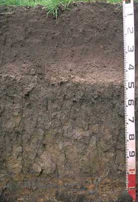 Vertic (& Ferric), Subnatric, Grey SODOSOL | |
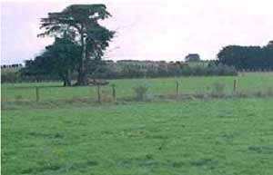
| Bostock Creek | |||
| Lower slope in gently undulating hills | |||
| Quarternary-Newer volcanics (scoria) | |||
| Lower slope | |||
Horizon | Depth (cm) | Description | ||
A11 | 0-15 | Black (10YR2/1); fine sandy clay loam; weak to moderate medium polyhedral, parting to moderate fine polyhedral structure; firm to very firm consistency (dry); weak-firm consistence (moist); pH 6.1; gradual boundary to: | ||
A12 | 15-40 | Very dark grey (10YR3/1); fine sandy clay loam; moderate medium polyhedral, parting to moderate fine polyhedral structure; weak-firm consistence (moist); pH 5.8; abrupt boundary to: | ||
A2 | 40-50 | Brown (10YR5/3), conspicuously bleached (7.5YR7/2dry); fine sandy clay loam; apedal structure; very many (> 50%) medium size (2–6 mm) ferruginous nodules; pH 6.5; sharp boundary to: | ||
B21 | 50-70 | Very dark greyish brown (becoming dark greyish brown (2.5Y4/2) with depth) with yellowish brown (10YR5/6) mottles; heavy clay; moderate very coarse prismatic, parting to moderate coarse to medium polyhedral structure; strong consistence (dry); pH 6.5; gradual boundary to: | ||
B22 | 70-100 | Greyish brown (2.5Y5/2), with yellowish brown (10YR5/8) mottles; heavy clay; strong very coarse prismatic, parting to coarse prismatic and very coarse blocky structure; strong consistence (dry); many slickensides present; pH 7.0; abrupt boundary to: | ||
C | 100+ | Weathered ash. | ||
| Management considerations | ||||
| Strong texture contrast between the surface soil and the subsoil is a very important soil feature. This can have a major effect by reducing and/or redirecting the internal drainage and restricting root growth beyond the upper horizons. Options include reduced tillage, improving organic matter content and altering the subsoil through artificial drainage (ripping, mole drainage) and/or chemical amelioration (gypsum) to improve structure. Bleached A2 horizons (or subsurface soils) are a major feature of many of soils within the Corangamite CMA region. They are an indication of restricted drainage, poor soil structure (often massive) and low organic matter, nutrient and water holding capacity, nearly always in conjunction with a restrictive soil below such as a clayey soil or a pan (eg. coffee rock). These bleached horizons may act as conduit for subsurface flow, particularly on sloping ground. If the soil is dispersive then gypsum application would be suitable, while increasing organic matter and maintaining vegetative cover is important. Mottled subsoils are common and are an indication of periodic waterlogging, particularly if the mottles are pale (low oxygen conditions). Some brighter mottling may be due to past soil mixing and clay alluviation. Improved drainage, with the application of gypsum for sodic subsoils may be beneficial. | ||||
Analytical data
Site SW27 | Sample depth | pH | EC | NaCl | Ex Ca | Ex Mg | Ex K | Ex Na | Ex Al | Ex acidity | FC (-10kPa) | PWP (-150kPa) | KS | FS | Z | C | |
Horizon | cm | H2O | CaCl2 | dS/m | % | cmolc/kg | cmolc/kg | cmolc/kg | cmolc/kg | mg/kg | cmolc/kg | % | % | % | % | % | % |
A11 | 0-15 | 6.1 | 5.7 | 0.29 | 0.02 | 14 | 2.3 | 0.6 | 0.1 | N/R | N/R | 39.3 | 18.2 | 6 | 39 | 22 | 19 |
A12 | 15-40 | 5.8 | 5 | 0.09 | N/R | 6.7 | 2.1 | 0.1 | 0.1 | N/R | N/R | 33.8 | 11.1 | 5 | 46 | 22 | 20 |
A2 | 40-50 | 6.5 | 5.6 | 0.08 | N/R | 4.5 | 2.2 | <0.1 | 0.2 | N/R | N/R | 26.4 | 10.7 | 29 | 33 | 15 | 19 |
B21 | 50-70 | 6.5 | 5.8 | 0.18 | N/R | 5.8 | 9.6 | 0.2 | 1.4 | N/R | N/R | 55.5 | 34.9 | 4 | 12 | 5 | 73 |
B22 | 70-100 | 7 | 6.1 | 0.18 | N/R | 4.7 | 11 | 0.2 | 2.4 | N/R | N/R | 26.1 | 32.3 | 3 | 14 | 8 | 72 |
© State of Victoria (Agriculture Victoria) 1996 - .

This work, Victorian Resources Online, is licensed under a Creative Commons Attribution 4.0 licence. You are free to re-use the work under that licence, on the condition that you credit the State of Victoria (Agriculture Victoria) as author, indicate if changes were made and comply with the other licence terms.
The licence does not apply to ‘branding’ or some ‘images or photographs’ that may be owned by third parties. We ask you to seek prior approval to use images using the VRO feedback form. Access to higher quality images can also be provided on request.
This page was last updated on .